21 BOUNDARY SURVEYS
Asterisks indicate problems that have answers given in Appendix G.
21.1 Define the following terms:
21.2 What is the primary responsibility of a professional surveyor?
(*)
© 2018 Pearson Education, Inc., Hoboken, NJ. All rights reserved. This material is protected under all
21.3 Visit your county courthouse and obtain a copy of a metes-and-bounds property
description. Write a critique of the description, with suggestions on how the
description could have been improved.
21.4 In a description by metes and bounds, what purpose may be served by the phrase
“more or less” following the acreage?
21.5 Write a metes-and-bounds description for the exterior boundary of lot 23 in Figure
21.2.
Metes-and bounds description of boundary for lot 15 in Figure 21.2.
21.6 Write a metes-and-bounds description for the house and lot where you live. Draw a
map of the property.
21.7 What are the essential elements required when writing a deed description by
coordinates?
21.8 From the metes-and-bounds description of the lot in the Town of Little Wolf,
described in Section 21.4, compute the lot’s misclosure.
From WolfPack: 0.003 ft
Title: Figure 21.1 Type: Polygon traverse
Unbalanced
3
———- ——— ———
Sum = 1,265.68 -0.003 –0.000
Balanced Coordinates
Dep Lat Point X Y
————————————————————
424.261 0.000 1 5,000.00 5,000.00
106.066 -106.066 2 5,424.26 5,000.00
-141.421 -141.421 3 5,530.33 4,893.93
-141.420 -0.000 4 5,388.91 4,752.51
-247.487 247.487 5 5,247.49 4,752.51
Linear misclosure = 0.003
Relative Precision = 1 in 466,600
Area: 85,000 sq. ft.
1.951 acres {if distance units are feet}
21.9 What is the point of commencement in a property description?
From Section 21.2, paragraphs 6:
21.10 What is the point of beginning in a property description?
21.11 What is the primary objective in performing a retracement surveys?
21.12* List in their order of importance the following types of evidence when conducting
retracement surveys: (a) measurements, (b) call for a survey, (c) intent of the parties,
(d) monuments, and (e) senior rights.
21.13 In performing retracement surveys, list in their order of importance, the four
different types of measurements called for in a description for your state.
© 2018 Pearson Education, Inc., Hoboken, NJ. All rights reserved. This material is protected under all
4
21.14 List in order the steps that must be performed in making subdivision surveys?
21.15 When writing a legal description using coordinates, what information must be
included in the description?
21.16 Why are lot-and-block descriptions not subject to junior and senior rights?
21.17 Two disputing neighbors employ a surveyor to check their boundary line. Discuss
the surveyor’s authority if (a) the line established is agreeable to both clients, and (b)
the line is not accepted by one or both of them.
21.18 What is the purpose of retracement surveys?
21.19 Compute the misclosure of lot 19 in Figure 21.2. On the basis of your findings,
would this plat be acceptable for recording? Explain.
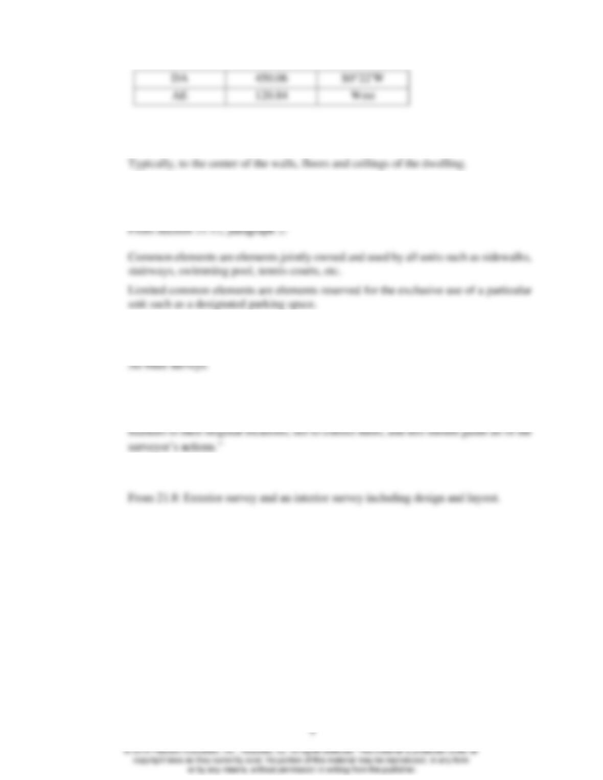
Lot 19
Course
Distance
Azimuth
Departure
Latitude
AB
56.76
95°30’
56.50
–5.44
BC
113.30
156°17’40”
45.55
–103.74
© 2018 Pearson Education, Inc., Hoboken, NJ. All rights reserved. This material is protected under all
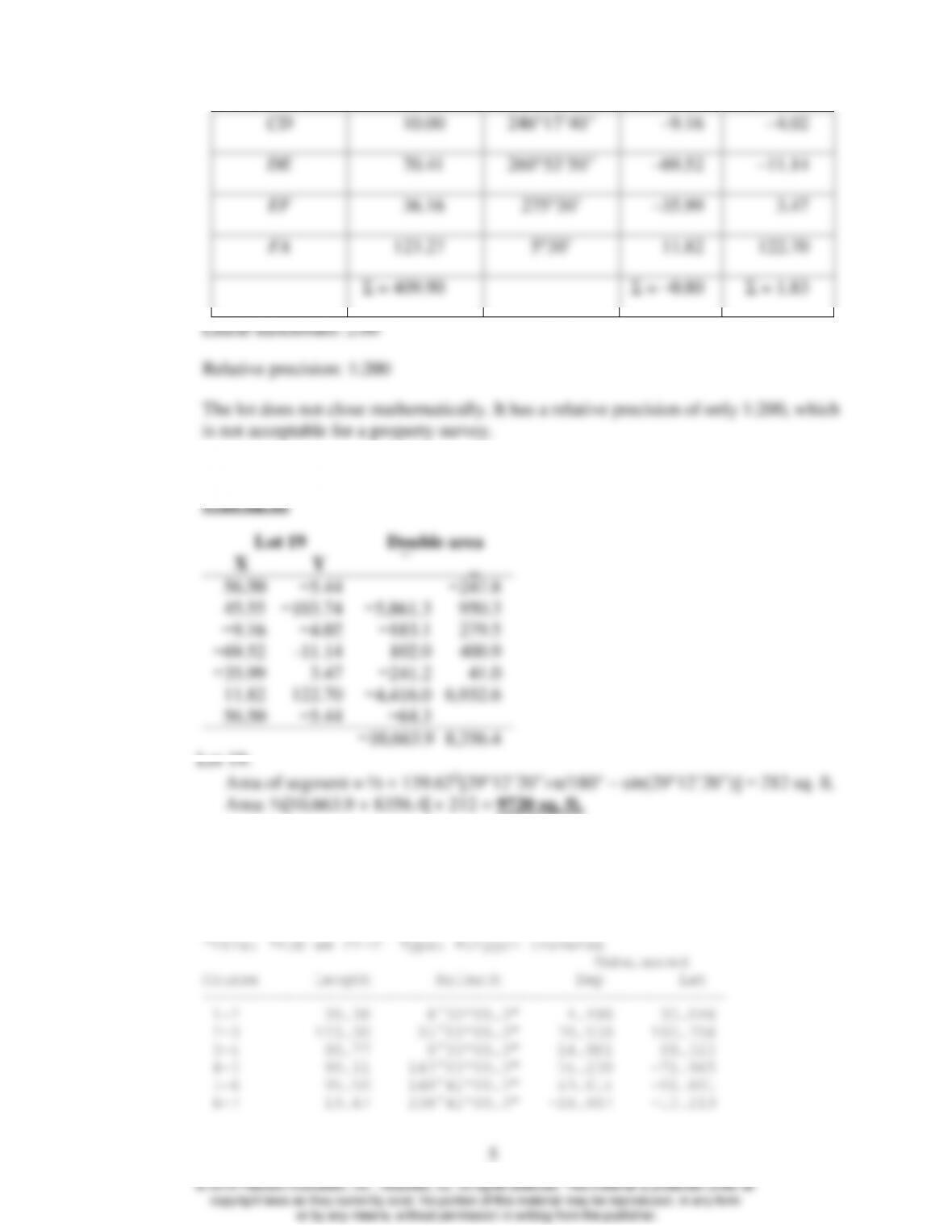
CD
10.00
246°17’40”
–9.16
–4.02
DE
70.41
260°53’50”
–69.52
–11.14
EF
36.16
275°30’
–35.99
3.47
FA
123.27
5°30’
11.82
122.70
Σ = 409.90
Σ = –0.80
Σ = 1.83
Linear misclosure: 2.00
Relative precision: 1:200
The lot does not close mathematically. It has a relative precision of only 1:200, which
is not acceptable for a property survey.
21.20* Compute the area of lot 19 of Figure 21.2.
9720 sq. ft.
Lot 19
Double area
X
Y
56.50
−5.44
−247.8
45.55
−103.74
−5,861.3
950.3
−9.16
−4.02
−183.1
279.5
−69.52
-11.14
102.0
400.9
−35.99
3.47
−241.2
41.0
11.82
122.70
−4,416.0
6,932.6
56.50
−5.44
−64.3
−10,663.9
8,356.4
Lot 19:
Area of segment = ½ 139.622[29°12’20”π/180° – sin(29°12’20”)] = 212 sq. ft.
Area: ½|10,663.9 + 8356.4| + 212 = 9720 sq. ft.
21.21 Determine the misclosure of lot 50 of Figure 21.2, and compute its area.
Computer solution:
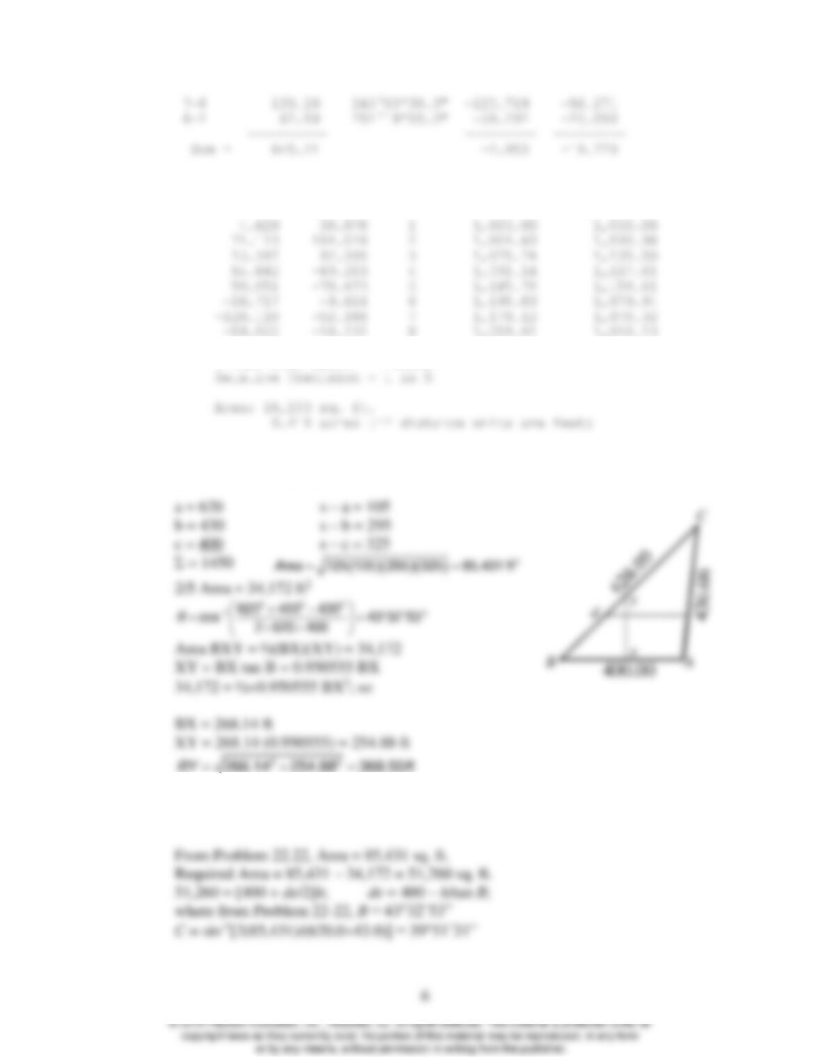
7-8 133.19 245°00’30.0″ -120.719 –56.271
8-1 62.59 251°19’00.0″ -59.292 –20.050
———- ——— ———
Sum = 645.21 -2.953 –19.779
Balanced Coordinates
Dep Lat Point X Y
~~~~~~~~~~~~~~~~~~~~~~~~~~~~~~~~~~~~~~~~~~~~~~~~~~~~~~~~~~~~
Linear misclosure = 19.998
21.22 For the accompanying figure; using a line perpendicular to AB through x, divide the
parcel into two equal parts, and determine lengths xy and By.
21.23 For the figure of Problem 21.22, calculate the length of line de, parallel to BA, which
will divide the tract into two equal parts. Give lengths Bd, de and eA.
7
A = 180° – 43°32’53” – 39°51’31” = 96°35’36”
51,260 = [400/2 + 400/2 – h/(2 tan B) + (h/2) tan (A+90°)]h
51,260 = 400 h – 0.4682 h2
h = 157.00 ft
de = 400 – 157.00/tan(43°32’53”) + 157.00 tan(6°35’36”) = 252.98 ft
Bd = 157.00/sin(43°32’53”) = 227.88 ft
Departure of Ae = 227.88 sin 43°32’53” + 252.98 – 400 = 9.98 ft
𝐴𝑒 =√9.982+157.002=1576.31 ft
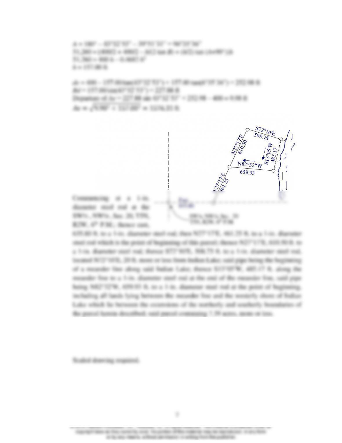
21.24 Prepare a metes-and-bound
description for the parcel
shown. Assume all corners
are marked with 1-in.
diameter steel rods, and a
20 ft. meander line setback
from Indian Lake.
21.25 Draw a plat map of the parcel in Problem 21.24 at a convenient scale. Label all
monuments and the lengths and directions of each boundary line on the drawing.
Include a title, scale, North arrow, and legend.
21.26 Prepare a metes-and-bounds description for the property shown. Assume all corners
are marked with 2-in. diameter iron pipes.
Indian
Lake
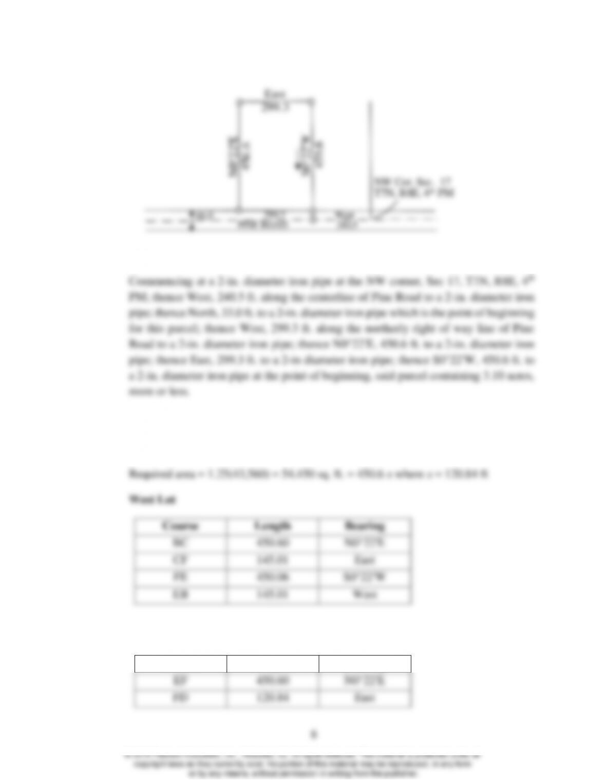
21.27 Create a 1.25-acre tract on the westerly side of the parcel in Problem 21.26 with a
line parallel to the westerly property line. Give the lengths and bearings of all lines
for both new parcels.
145.01
East Lot: AE = 299.13 – 120.84 = 178.46 ft
Course
Length
Bearing
EF
450.60
N0°22′E
FD
120.84
East
NW Cor. Sec. 17
T7N, R8E, 4th PM
West
240.5PINE ROAD
66.0
East
299.3
299.3
DA
450.06
S0°22′W
AE
120.84
West
21.28 Discuss the ownership limits of a condominium unit.
21.29 Define common elements and limited common elements in relation to condominiums.
Given examples of each.
21.30 What types of measurements are typically made by surveyors in performing work for
condominium developments?
21.31 What is the objective of a resurvey of an existing property?
From 21.7, paragraph 1: “The objective of resurveys therefore is to restore boundary
21.32 List in order the steps that must be performed in making subdivision surveys.