
20 STATE PLANE COORDINATES AND OTHER MAP PROJECTIONS
Asterisks indicate problems that have answers given in Appendix G.
20.1 Discuss the advantages of placing surveys on state plane coordinate systems.
20.2 What is a developable surfaces?
20.3 Which developable surfaces are typically used in the state plane coordinate system.
20.4 What three map projections are used in state plane coordinates?
20.5 What surveying observations are distorted by a conformal map projection?
20.6 What are the defining parameters for the Lambert conformal conic map projection?
20.7 Develop a table of SPCS83 elevation factors for geodetic heights ranging from 0 to 1000
m. Use increments of 100 m and an average radius for the Earth of 6,371,000 m.
Height (m)
Scale
(*)
© 2018 Pearson Education, Inc., Hoboken, NJ. All rights reserved. This material is protected under all
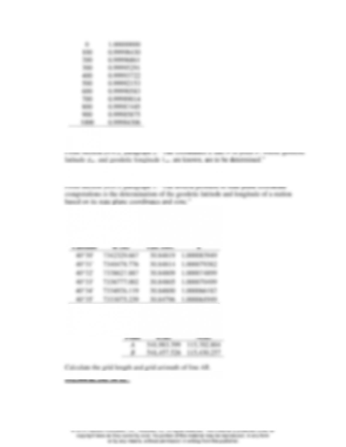
0
1.00000000
100
0.99998430
200
0.99996861
300
0.99995291
400
0.99993722
500
0.99992153
600
0.99990583
700
0.99989014
800
0.99987445
900
0.99985875
1000
0.99984306
20.8 Define the direct problem in state plane coordinates.
20.9 Define the inverse problem in state plane coordinates.
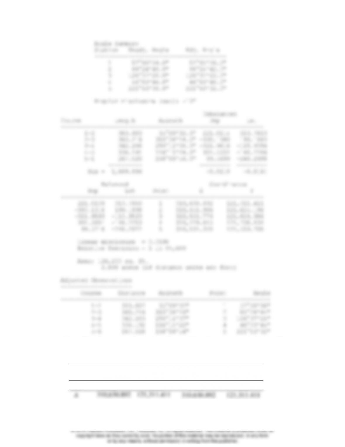
20.10 Develop a table similar to Table 20.1 for a range of latitudes from 40°30′ N to 40°35′ N
in the Pennsylvania North Zone with standard parallels of 40°53′ N and 41°57′ N, and a
grid origin at (40°10′ N, 77°45′ W).
Latitude
R (m)
Tab. Diff.
k
40°30′
7342329.667
30.84819
1.000083949
40°31′
7340478.776
30.84814
1.000079382
40°32′
7338627.887
30.84809
1.000074899
40°33′
7336777.002
30.84805
1.000070499
40°34′
7334926.119
30.84800
1.000066182
40°35′
7333075.239
30.84796
1.000061949
*20.11 The Pennsylvania North Zone SPCS83 state plane coordinates of points A and B are as
follows:
Point
E(m)
N(m)
A
541,983.399
115,702.804
B
541,457.526
115,430.257
Calculate the grid length and grid azimuth of line AB.
592.304 m, 242°36′12″
20.12 Similar to Problem 20.11, except points A and B have the following New Jersey SPCS83
state plane coordinates:
© 2018 Pearson Education, Inc., Hoboken, NJ. All rights reserved. This material is protected under all

Point
E(m)
N(m)
A
131,124.094
264,920.458
B
131,391.924
264,523.316
479.014 m, 146°00′16″
20.13 What are the SPCS83 coordinates (in sft) and convergence angle for a station in the North
zone of Pennsylvania with geodetic coordinates of 41°14′14.22063″ N and
76°43′34.06012″ W?
20.14* Similar to Problem 20.13 except that the station’s geodetic coordinates are
41°13’20.03582″ N and 75°58’46.28764″ W. Give coordinates in meters.
From WolfPack:
20.17* What are the SPCS83 coordinates in meters for a station in New Jersey with geodetic
coordinates of 40°44′32.73687″ N and 74°10′45.47356″ W?
20.18 Similar to Problem 20.17 except that the geodetic coordinates of the station are
20.19 What are the convergence angle and scale factor at the station in Problem 20.17?
20.20 What are the convergence angle and scale factor at the station in Problem 20.18?
20.21 What is the grid azimuth and grid distance in meters between the points in Problems 20.17
and 20.18?
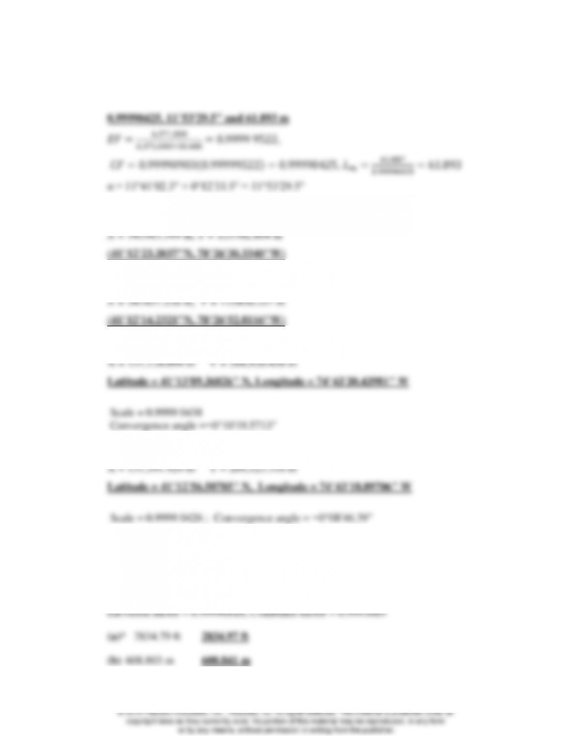
20.22 If the average geodetic height of the line between the points in Problems 20.17 and 20.18
is 100 ft, what is the combined factor for the line, geodetic azimuth, and ground distance
in meters? (Use an average radius for the Earth of 6,371,000 m)
20.23* What are the geodetic coordinates for a point A in Problem 20.11?
20.24 Similar to Problem 20.23 except for point B in Problem 20.11?
20.25* What are the geodetic coordinates for a point A in Problem 20.12?
20.26 Similar to Problem 20.25 except for point B in Problem 20.12.
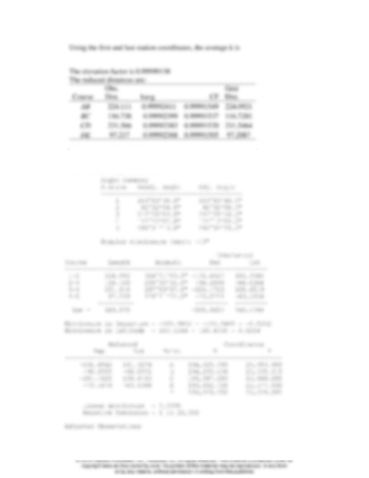
20.27 In computing state plane coordinates for a project area whose mean orthometric height is
234 m, an average scale factor of 0.99996871 was used. The average geoid height for the
area is −31.284 m. The given distances between points in this project area were computed
from SPCS83 state plane coordinates. What horizontal length would have to be observed
to lay off these lines on the ground? (Use 6,371,000 m for an average radius for the Earth.)
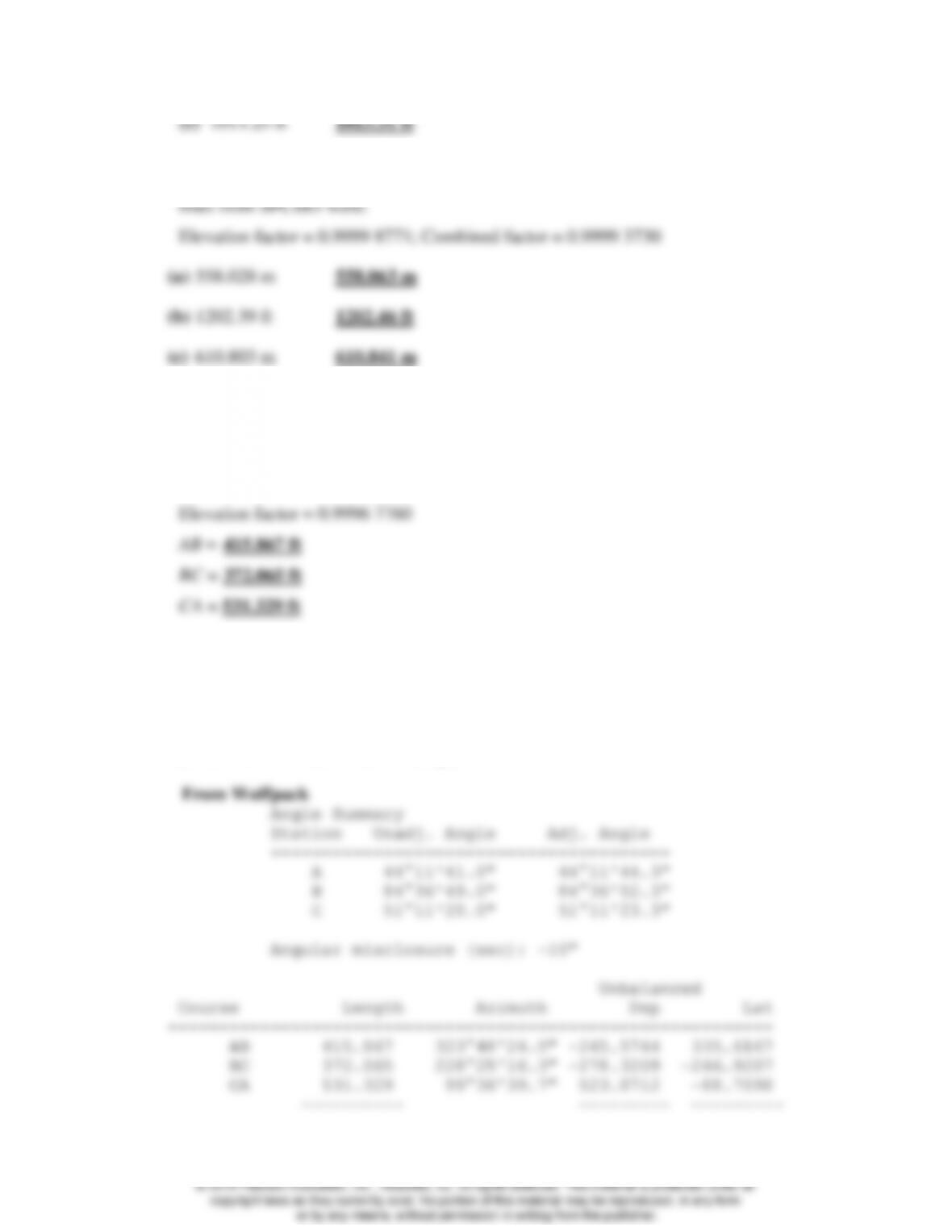
20.28 Similar to Problem 20.27, except that the mean project area elevation was 100.997 m, the
geoidal separation −22.663 m, the scale factor 0.99994959, and the computed lengths of
20.29 The horizontal ground lengths of a three-sided closed polygon traverse were measured in
feet as follows: AB = 416.04, BC = 372.22, and CA = 531.55 ft. If the average scale factor
is 0.99990643, orthometric height of the area is 6843.68 ft, and the average geoid height
is −31.273 m, calculate grid lengths of the lines suitable for use in computing SPCS83
coordinates. (Use 6,371,000 m for an average radius for the Earth.)
20.30 For the traverse of Problem 20.29, the grid azimuth of a line from A to a nearby azimuth
mark was 309°22′06″ and the clockwise angle measured at A from the azimuth mark to
B, 14°26′18″. The measured interior angles were A= 44°11′41″, B = 84°36′49″, and C =
51°11′20″. Balance the angles and compute grid azimuths, latitudes and departures
balanced latitude and departures, linear misclosure, and relative precision for the traverse.
(Note: Line BC bears southwesterly.)
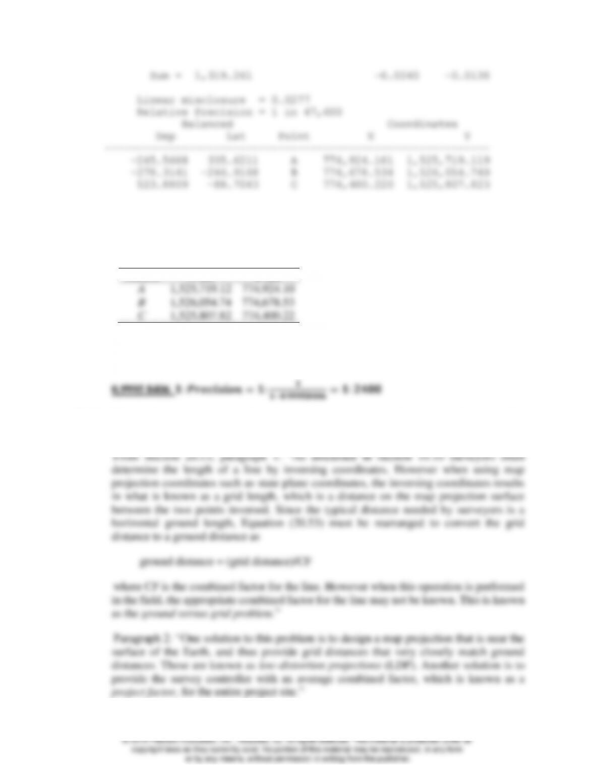
20.31 Using grid lengths and azimuths of Problem 20.30 and the fact that the (N, E) coordinates
in meters for Station A are (465,040.178, 236,197.338), calculate coordinates of the
stations in feet.
From WolfPack (see 20.30)
Station
N (ft)
E (ft)
A
1,525,719.12
774,924.10
B
1,526,054.74
774,678.53
C
1,525,807.82
774,400.22
20.32* What is the combined factor for the traverse of Problem 20.30, and what distance
precision does this yield when grid distances are compared to ground distances?
20.33 What is the ground versus grid problem and what two methods can be used to solve this
problem?
20.34 What scale factor should be used with the Lambert conformal conic map projection when
creating an LDP that is secant to the Earth at the height of havg? …for the Transverse
Mercator map projection?
20.35 The average geodetic height in a project area is 6892.76 ft. Using an average radius of
the Earth of 6,371,000 m, what is the appropriate scale factor for an LDP using the
Transverse Mercator projection in an LDP?
39.37)
20.36 The traverse in Problems 10.9 through 10.11 was performed in the Pennsylvania North
Zone of SPCS83. The average elevation for the area was 505.87 m and the average
geoidal height was −31.56 m. Using the data in Table 20.1 and a mean radius for the
Earth, compute a project factor, reduce the observations to grid, and adjust the traverse.
Compare this solution with that obtained in Chapter 10. (Use 6,371,000 m for an average
radius of the Earth.)
Using the initial coordinates (in meters) from Chapter 10, the scale factor at each station
is (from WolfPack):
Note: The adjusted coordinates from Chapter 10 and here are provided below. The same
linear misclosure and relative precision was achieved even though the coordinates vary
as shown since the traverse was scaled incorrectly in Chapter 10.
Initial
Coordinates
Grid Coordinates
Sta
E (m)
N (m)
E (m)
N (m)
A
310,630.892
121,311.411
310,630.892
121,311.411
© 2018 Pearson Education, Inc., Hoboken, NJ. All rights reserved. This material is protected under all
copyright laws as they currently exist. No portion of this material may be reproduced, in any form
or by any means, without permission in writing from the publisher.
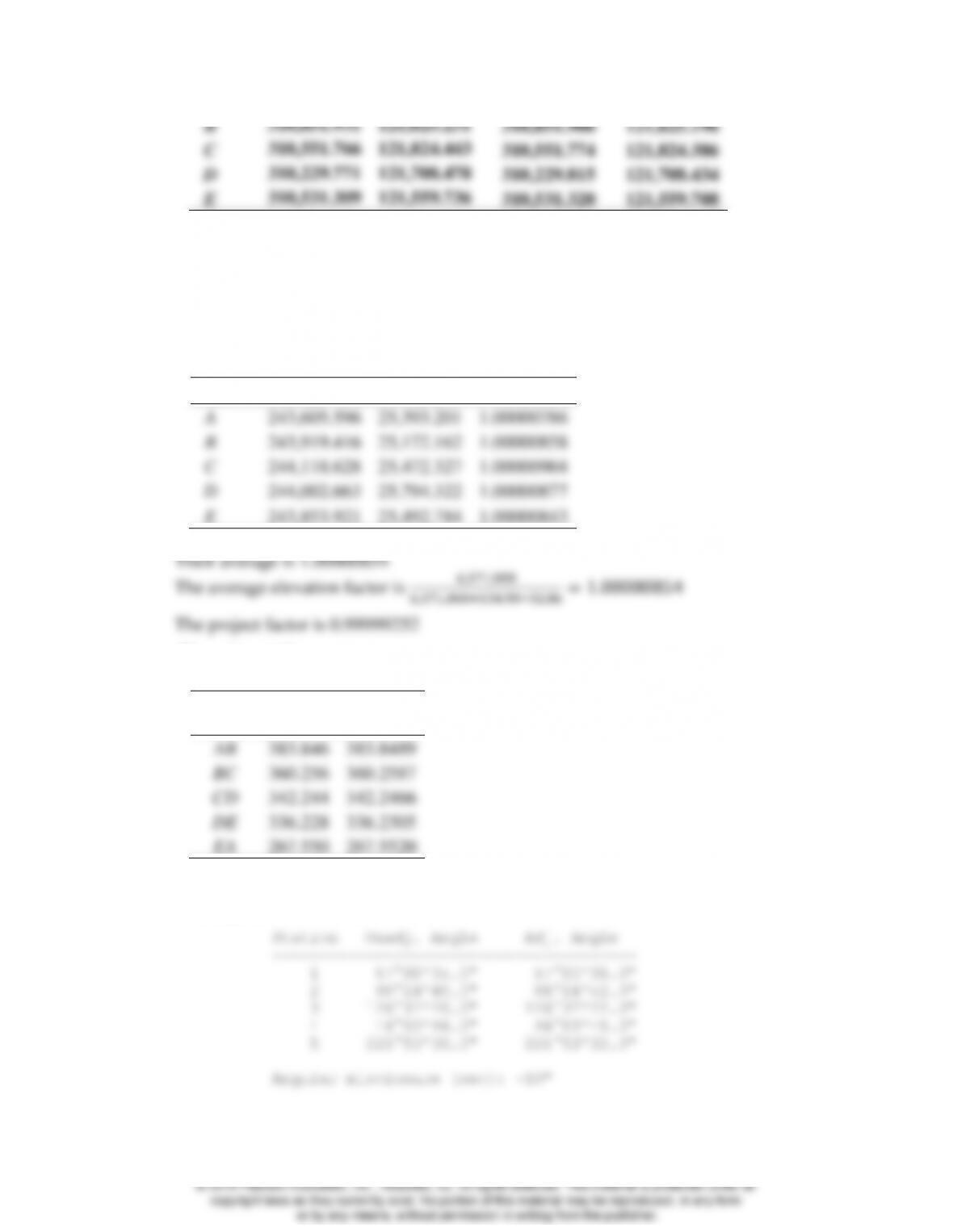
B
310,851.931
121,625.231
310,851.906
121,625.196
C
310,551.766
121,824.443
310,551.774
121,824.386
D
310,229.771
121,708.478
310,229.815
121,708.434
E
310,531.309
121,559.736
310,531.320
121,559.708
20.37 The traverse in Problems 10.12 through 10.14 was performed in the New Jersey zone of
SPCS83. The average elevation for the area was 134.93 m and the average geoidal
separation was −32.86 m. Using the data in Table 20.3 and 20.4, and a mean radius for
the earth, compute a project factor, reduce the observations to grid, and adjust the traverse.
Compare this solution with that obtained in Chapter 10.
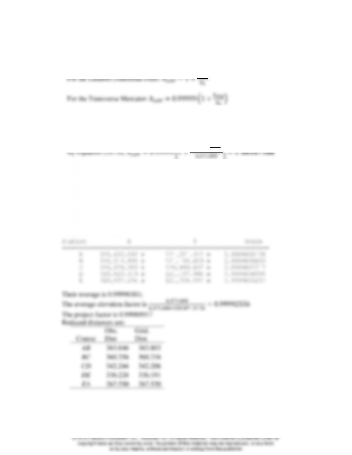
Using the initial coordinates from Chapter 10, the scale factor at each station is:
Sta
E (m)
N (m)
k
A
243,605.596
25,393.201
1.00000786
B
243,919.416
25,172.162
1.00000858
C
244,118.628
25,472.327
1.00000904
D
244,002.663
25,794.322
1.00000877
E
243,853.921
25,492.784
1.00000843
Their average is 1.00000854
The reduced distances are:
Course
Obs.
Dist.
Grid
Dist.
AB
383.846
383.8489
BC
360.256
360.2587
CD
342.244
342.2466
DE
336.228
336.2305
EA
267.550
267.5520
The adjusted traverse from WolfPack:
© 2018 Pearson Education, Inc., Hoboken, NJ. All rights reserved. This material is protected under all
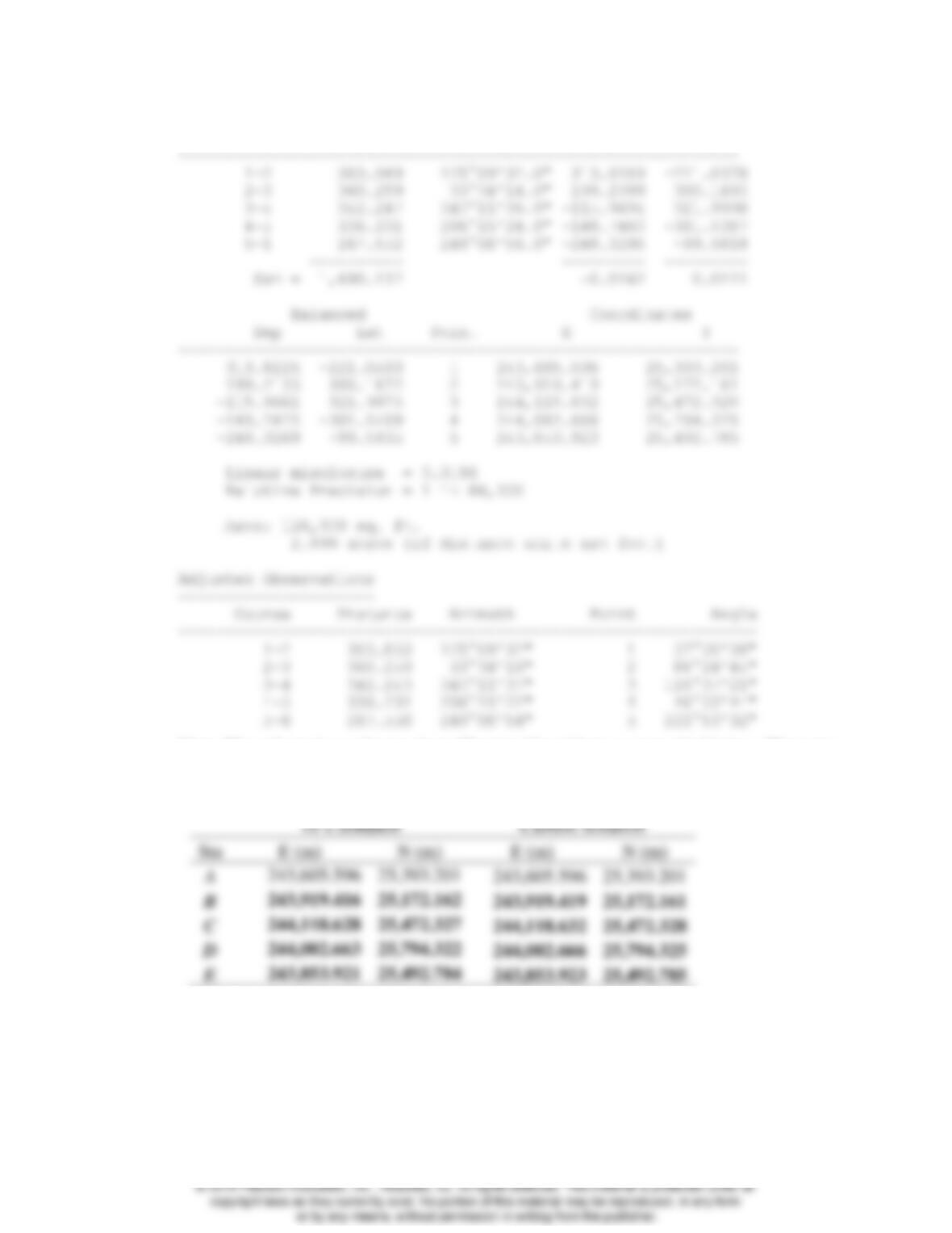
Unbalanced
Course Length Azimuth Dep Lat
Note: The adjusted coordinates from Chapter 10 and here are provided below. The same
linear misclosure and relative precision was achieved even though the coordinates vary
as shown since the traverse was scaled incorrectly in Chapter 10.
10’s Solution
Current Solution
Sta
E (m)
N (m)
E (m)
N (m)
A
243,605.596
25,393.201
243,605.596
25,393.201
B
243,919.416
25,172.162
243,919.419
25,172.161
C
244,118.628
25,472.327
244,118.632
25,472.328
D
244,002.663
25,794.322
244,002.666
25,794.325
E
243,853.921
25,492.784
243,853.923
25,492.785
20.38 The traverse in Problem 10.21 was performed in the Pennsylvania SPCS 1983 north zone.
The average elevation of the area was 85.78 m and the average geoid height was −31.85
m. Using 6,371,000 m for the mean radius of the earth, compute a project factor, reduce
the observations to grid, and adjust the traverse using the compass rule. Compare this
solution with that obtained in Problem 10.22.
© 2018 Pearson Education, Inc., Hoboken, NJ. All rights reserved. This material is protected under all
———————
Note: That solution from Chapter 10 and here are different since this is a link traverse.
The relative precision went from 1:8,800 to 1:20,300. The coordinates vary as shown
below since the traverse was scaled incorrectly in Chapter 10.
Initial coordinates
Final coordinates
Sta
E (m)
N (m)
E (m)
N (m)
A
194,325.090
25,353.988
194,325.090
25,353.988
B
194,193.440
25,535.326
194,193.436
25,535.315
C
194,097.180
25,469.288
194,097.180
25,469.285
D
193,892.720
25,577.937
193,892.718
25,577.930
E
193,819.150
25,514.391
193,819.150
25,514.391
20.39* If the geodetic azimuth of a line is 205°06’36.2″ the convergence angle is −0°42’26.1″
and the arc-to-chord correction is +0.8″ what is the equivalent grid azimuth for the line?
20.40 If the geodetic azimuth of a line is 243°06′34.5″ the convergence angle is 0°46′44.2″ and
the arc-to-chord correction is −0.9″, what is the equivalent grid azimuth for the line?
20.41 Using the values given in Problems 20.39 and 20.40, what is the acute grid angle between
the two azimuths?
20.42 The grid azimuth of a line is 158°13′26″. If the convergence angle at the endpoint of the
azimuth is −1°58′02.9″ and the arc-to-chord correction is +1.5″, what is the geodetic
azimuth of the line?
20.43 Similar to Problem 20.42, except the convergence angle is +2°16′32.7″ and the arc-to–
chord correction is +1.6″.
20.44 A project is bounded by the geodetic coordinates in the southwest corner of (32°15′37″
N, 106°48′49″W, 1180 m) and in the northeast corner of (32°21′43″ N, 106°43′56″W,
1290 m). Should the transverse Mercator or the Lambert conformal conic map projection
be used in the design of an LDP for the region?
© 2018 Pearson Education, Inc., Hoboken, NJ. All rights reserved. This material is protected under all

20.45 In Problem 20.44 what scale factor (kLDP) be used in the design of the LDP? (Use an
average radius for the Earth.)
20.46 The region in problem 20.44 is surrounds Las Cruces, NM, which is in the New Mexico
Central Zone of the SPCS 1983. What is the appropriate project factor for this region?

© 2018 Pearson Education, Inc., Hoboken, NJ. All rights reserved. This material is protected under all