17 MAPPING SURVEYS
Asterisks indicate problems that have answers given in Appendix G.
17.1 What methods can be used to display relief on a map?
17.2 What is the difference between a planimetric and topographic map?
17.3 Define map scale.
17.4 What different methods can be used to show a map’s scale?
17.5 Define the term large-scale map.
17.6* On a map sheet having a scale of 1 in. = 360 ft, what is the smallest distance (in feet)
that can be plotted with an engineer’s scale? (Minimum scale graduations are 1/60th in.)
1360 ft
60
17.7 What equivalent scales are suitable to replace the following ratio scales: 1:480, 1:720, 1:3600,
(*)
© 2018 Pearson Education, Inc., Hoboken, NJ. All rights reserved. This material is protected under all
and 1:6000?
17.8 A topographic map has a contour interval of 1 ft and a scale of 1:600. If two adjacent
contours are 0.25 in. apart, what is the average slope of the ground between the contours?
17.9 What are the ratio scales for the equivalent scales of 1 in. = 20 ft, 1 cm = 5 m, and 1 in.
= 30 ft?
17.10* On a map whose scale is 1 in. = 40 ft, how far apart (in inches) would 1-ft contours be
on a uniform slope (grade) of 2%?
17.11 Why should caution be used in enlarging a map?
17.12 On a map drawn to a scale of 1:1000, contour lines are 2 mm apart at a center location.
The contour interval is 0.1 m. What is the ground slope in percent, between adjacent
contours?
17.13 The line width on a map of scale 1:2000 is 0.2 mm. What should the accuracy of the
survey be to draw this map?
17.14 When should points be located for contours connected by straight lines? When by
smooth curves?
17.15* What conditions in the field need to exist when using kinematic satellite survey?
17.16 What is a digital terrain model?
17.17 What is a contour? …a contour interval?
17.18 Why are spot elevations placed on maps?
17.19 Between the elevations of 649 and 659 at what elevations will contours be drawn for a
2-ft contour interval and which contours will be labeled?
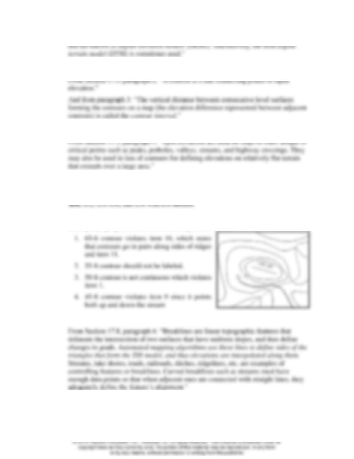
17.20 Using the rules of contours, list the contouring mistakes that are shown in the
accompanying figure and list the contouring rule it violates.
17.21 Describe the purpose of a breakline in defining contours by automated processes.
© 2018 Pearson Education, Inc., Hoboken, NJ. All rights reserved. This material is protected under all
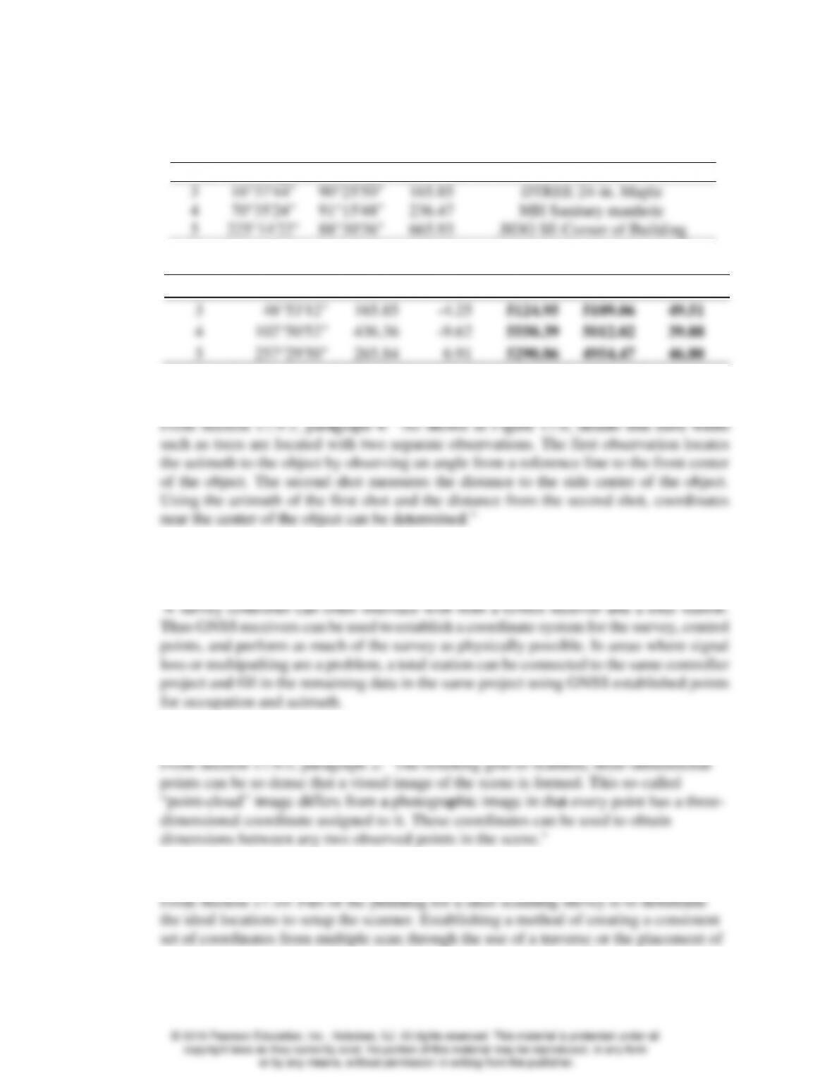
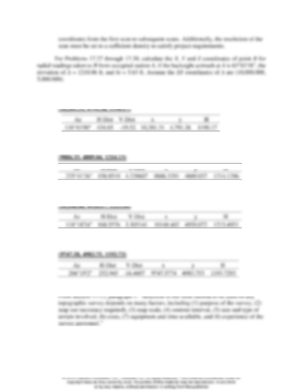
17.22 Assuming xy coordinates for the instrument station of (5000, 5000), a backsight azimuth
of 32°15′28″ and height of instrument of 53.76 ft, determine the coordinates and
elevations for points 3, 4, and 5 in Table 17.1.
Point
Hor. Angle
Zen. Angle
Distance
Notes
3
4
5
16°37’44”
70°35’24”
225°14’22”
90°25’50”
91°15’48”
88°30’36”
165.85
236.47
665.93
DTREE 24-in. Maple
MH Sanitary manhole
.BDG SE Corner of Building
Point
Azimuth
H-Dist
V-Dist
x
y
H
3
48°53’12”
165.85
-4.25
5124.95
5109.06
49.51
4
102°50’52”
436.36
-9.62
5550.39
5012.02
39.88
5
257°29’50”
265.84
6.91
5290.86
4954.47
46.80
17.23 How is a tree with significant width located?
17.24 Discuss how a survey controller with a total station instrument can be combined with
GPS methods to collect data for a topographic map.
17.25 What does the term “point cloud” describe in laser-scanning?
17.26 What factors must be considered when planning a laser scanning survey?
multiple targets on the surface of the object being scanned that will extend the
17.27* Clockwise horizontal angle = 55°37’42”, zenith angle 92°34’18”, slope distance =
435.09 ft, hr = 6.00 ft.
17.32 What is the advantage of coding data points when combined with field-to-finish
software?
17.33* On a map having a scale of 200 ft/in. the distance between plotted fixes 49 and 50 of
Figure 17.14 is 3.15 in. From measurements on the profile of Figure 17.13, determine
how far from fix 50 the 20-ft contour (existing between fixes 49 and 50) should be
plotted on the map.
17.34 Similar to Problem 17.33, except locate the 16-ft contour between fixes 50 and 51 if the
corresponding map distance is 2.98 in.
17.35 What is a hydrographic survey?
© 2018 Pearson Education, Inc., Hoboken, NJ. All rights reserved. This material is protected under all