Unlock document.
This document is partially blurred.
Unlock all pages and 1 million more documents.
Get Access
Notes to Instructors
Chapter 52 An Introduction to Ecology and the Biosphere
What is the focus of this activity?
Ecology is the scientific study of the interactions of organisms and their environments.
What is this particular activity designed to do?
Activity 52.1 What factors determine climate?
Answers
Activity 52.1 What factors determine climate?
The map on page 343 shows a hypothetical continent on Earth. Assume that biomes and
Where needed, draw the required features directly on the map.
1. a. On the map of the hypothetical continent, indicate the location(s) of the biomes
listed in the table below. To do this, draw approximate boundary lines to delimit
each biome type, and then label each delimited area with the type of biome it
contains.
Use the information in Figures 52.3, 52.10, and 52.15 of Campbell Biology,

b. In the table indicate the annual temperature and precipitation ranges for each biome.
342 Activity 52.1
Biome type Annual temperature and precipitation ranges
a. Tropical rain
forest(s)
In general, tropical rain forests lie between the equator and
about 25° north and south latitudes, where the annual
mean precipitation exceeds 150 cm and the annual mean
temperature exceeds about 23°C.
d. Temperate forest(s) Temperate forests tend to lie between 25° and 60° north
and south latitudes, where the annual mean precipitation
ranges from 70 to 200 cm and the annual temperature
range is from below zero to 30°C.
2. Atmospheric circulation is driven primarily by differential heating of Earth’s surface.
More heat is delivered near the equator than near the poles. This seems to explain the
northward and southward flows of air. What introduces the eastward and westward
components into air movement? (Hint: Review Figure 52.3, Global Air Circulation
and Precipitation Patterns and Global Wind Patterns, in Campbell Biology, 9th edition.)
As indicated in Figure 52.3, “as Earth rotates on its axis, land near the equator
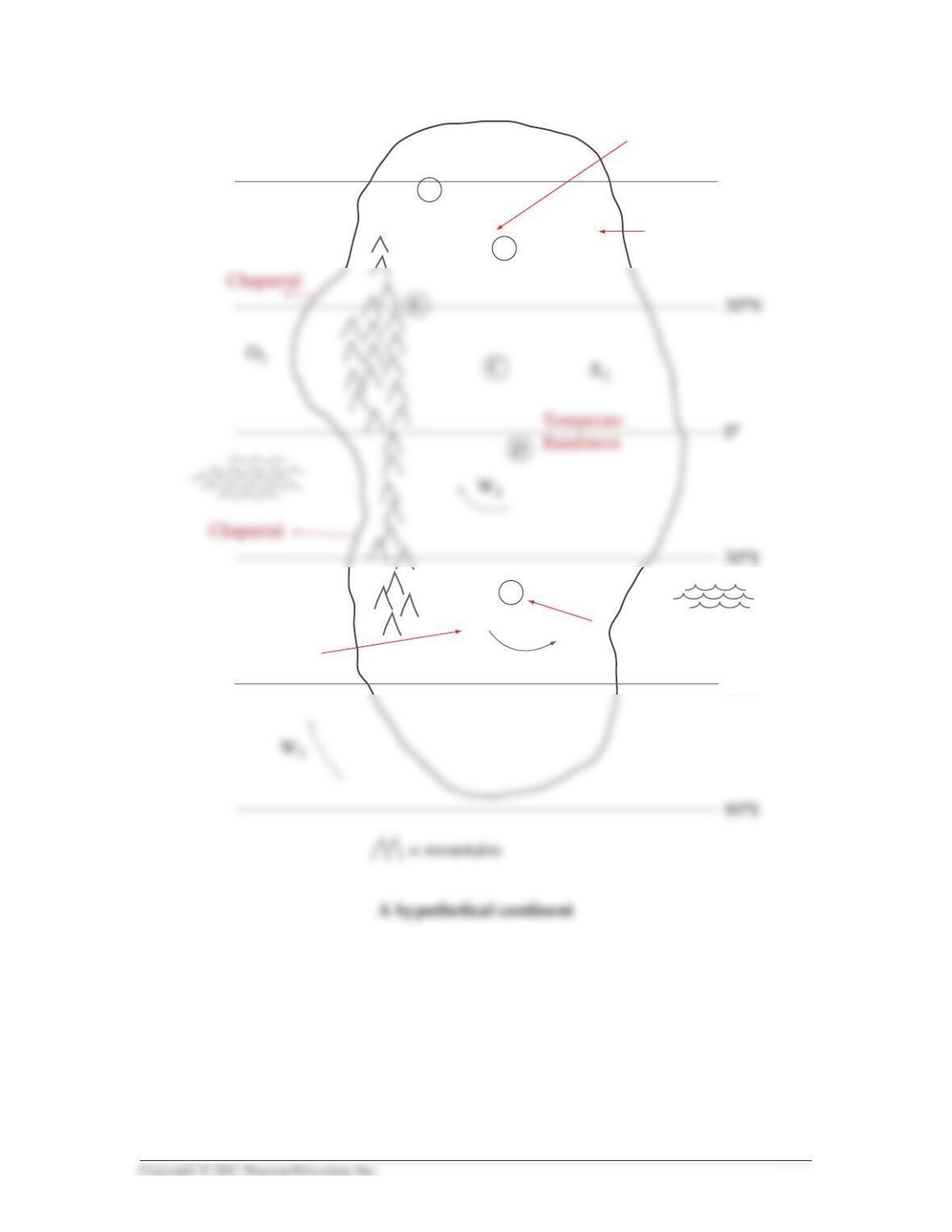
Activity 52.1 343
60ºN
60ºS
A
Tundra
Temperate
grassland
Temperate
forest
Temperate forest
Temperate
Grass
B
F
X1
W1
O3
X3

3. Use your understanding of global air circulation and wind patterns to draw arrows
on the map of the hypothetical continent indicating:
a. The direction of prevailing winds at points W1, W2, and W3
4. Are the surface winds at the given points warming or cooling as they move? Explain.
344 Activity 52.1
Point on the map
Are the winds
warming or cooling
as they move? Explanation
a. X1The winds are warming The general wind pattern in this
area is from the southwest
5. What biomes or vegetation types would most likely be found at the given points?
(Assume all are at sea level or low altitudes.)
Point on the map Most likely type of biome or vegetation
AThis region would most likely contain coniferous forest.

6. Would the climate at point E be relatively wet or dry? Explain.
7. What would the direction of the prevailing winds be at Earth’s surface at point X3?
8. In the United States, temperate forest extends from the East Coast westward for
about 1,200 miles (to the Mississippi River Valley). From there, the forest begins to
thin out toward the west into oak savannas (or temperate woodland), and it finally
gives way to open grassland (Great Plains). The grasslands extend 1,000 miles
westward to the foothills of the Rocky Mountains.
a. Why does grassland replace forest west of the Mississippi River?
This area is under the influence of the westerlies (wind flow pattern), which carry
moist air from the Pacific Ocean onto the North American continent. When these
b. What is the rain shadow effect?
As noted in part a, the rain shadow effect occurs on the leeward side of mountain
c. Draw a rain shadow somewhere in the southern hemisphere of the map.
The rain shadow is always on the leeward side of the mountain. Therefore, in the
9. What biome would exist at point F?
Point F is at the transition between temperate grassland and temperate forest. It is
Activity 52.1 345

10. How are the general characteristics of plants (for example, morphology) influenced
by climate? In other words, explain what effects climate has on the types of plants
that grow in an area.
As indicated in Figure 52.10, the type of biome is strongly influenced by both the
11. Refer to Figure 52.10 in Campbell Biology, 9th edition. In general, how is the
distribution of major ecosystems or biomes related to climate? If you know the mean
annual precipitation and the mean annual temperature of an area, would you be able
to accurately predict the type of biome that could exist there? Explain.
As noted above, the type of biome or ecosystem is determined by the mean annual
temperature and the mean annual precipitation in an area. However, how the
12. Why isn’t Earth’s climate uniform? To answer this, summarize the major factors that
can produce differences in climate from place to place.
The primary factors affecting the type of climate are the annual amount of solar
346 Activity 52.1
1. A large asteroid hits the Earth, and alters its axis tilt from 23.5° to 10°.
a. What effect(s) would this have on seasons in the northern hemisphere?
With less tilt, there would be less seasonality. Overall, the seasons would be
b. What effect(s) would this have on biome distribution in the Northern
Hemisphere? (Refer to Figure 52.10 in Campbell Biology, 9th edition.)
As the annual mean temperature increased, we would see much less tundra and
2. If you travel across the United States on a line from North Carolina to Southern California,
you will find that deciduous forest extends from the East Coast westward for approximately
1,200 miles to about the valley of the Mississippi River. There it begins to thin out toward the
west into oak savannas and finally gives way entirely to open grassland (Great Plains),
which extends another 1,000 miles westward up into the foothills of the Rocky Mountains.
If you cross over the mountains you find chaparral in Southern California.
3 to 6. The type of vegetation that will grow in a particular region of the earth is
strongly affected by:
T/F 5. Seasonal availability of water.
True
Activity 52.1 347
Name _______________________ Course/Section_______________________
52.1 Test Your Understanding


