28 INTRODUCTION TO GEOGRAPHIC INFORMATION SYSTEMS
Asterisks
(*)
indicate problems that have partial answers given in Appendix G.
28.1 Describe the concept of layers in a geographic information system.
28.2 Discuss the role of a geographic reference framework in a GIS.
28.3 List the fundamental components of a GIS.
28.4 List the fields within surveying and mapping that are fundamental to the
development and implementation of GISs.

28.5 Discuss the importance of metadata to a GIS.
28.6 Name and describe the different simple spatial objects used for representing
graphic data in digital form. Which objects are used in raster format
representations?
28.7 What are the primary differences between a GIS and LIS?
© 2018 Pearson Education, Inc., Hoboken, NJ. All rights reserved. This material is protected under all

28.8 How many pixels are required to convert the following documents to raster form
for the conditions given:
28.9 Explain how data can be converted from:
28.10 For what types of data is the vector format best suited?
28.11 Discuss the compromising relationships between grid cell size and resolution in
raster data representation.
28.12 Define the term topology and discuss its importance in a GIS.
28.13 Develop identifier and topology tables similar to those of Tables 28.1 and 28.2 in
the text for the vector representation of (see the following figures):
(a) Problem 28.13(a)
Identifier
Coordinates
Line
Identifier
Points
Area
Identifier
Lines
1
x1,y1
a
1,2
I
a,g,f,e
2
x2,y2
b
2,3
II
b,h,g
© 2018 Pearson Education, Inc., Hoboken, NJ. All rights reserved. This material is protected under all
copyright laws as they currently exist. No portion of this material may be reproduced, in any form
or by any means, without permission in writing from the publisher.
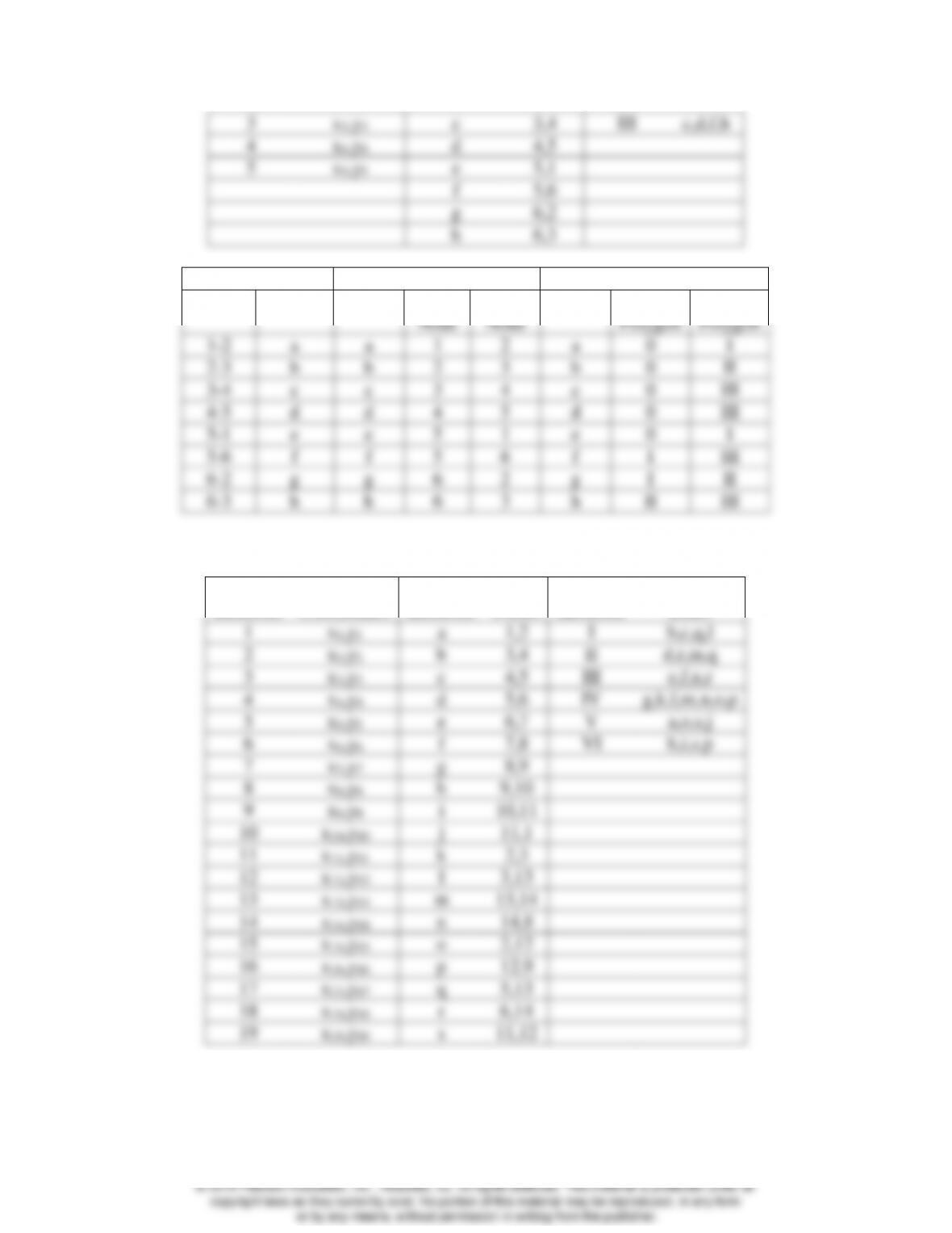
3
x3,y3
c
3,4
III
c,d,f,h
4
x4,y4
d
4,5
5
x5,y5
e
5,1
f
5,6
g
6,2
h
6,3
Connectivity
Direction
Adjacency
Nodes
Chains
Chain
From
Node
To
Node
Chain
Left
Polygon
Right
Polygon
1-2
a
a
1
2
a
0
I
2-3
b
b
2
3
b
0
II
3-4
c
c
3
4
c
0
III
4-5
d
d
4
5
d
0
III
5-1
e
e
5
1
e
0
I
5-6
f
f
5
6
f
I
III
6-2
g
g
6
2
g
I
II
6-3
h
h
6
3
h
II
III
(b) Problem 28.13(b)
Identifier
Coordinates
Line
Identifier
Points
Area
Identifier
Lines
1
x1,y1
a
1,2
I
b,c,q,l
2
x2,y2
b
3,4
II
d,r,m,q
3
x3,y3
c
4,5
III
e,f,n,r
4
x4,y4
d
5,6
IV
g,k,l,m,n,o,p
5
x5,y5
e
6,7
V
a,o,s,j
6
x6,y6
f
7,8
VI
h,i,s,p
7
x7,y7
g
8,9
8
x8,y8
h
9,10
9
x9,y9
i
10,11
10
x10,y10
j
11,1
11
x11,y11
k
2,3
12
x12,y12
l
3,13
13
x13,y13
m
13,14
14
x14,y14
n
14,8
15
x15,y15
o
2,12
16
x16,y16
p
12,9
17
x17,y17
q
5,13
18
x19,y18
r
6,14
19
x19,y19
s
11,12
© 2018 Pearson Education, Inc., Hoboken, NJ. All rights reserved. This material is protected under all
copyright laws as they currently exist. No portion of this material may be reproduced, in any form
or by any means, without permission in writing from the publisher.
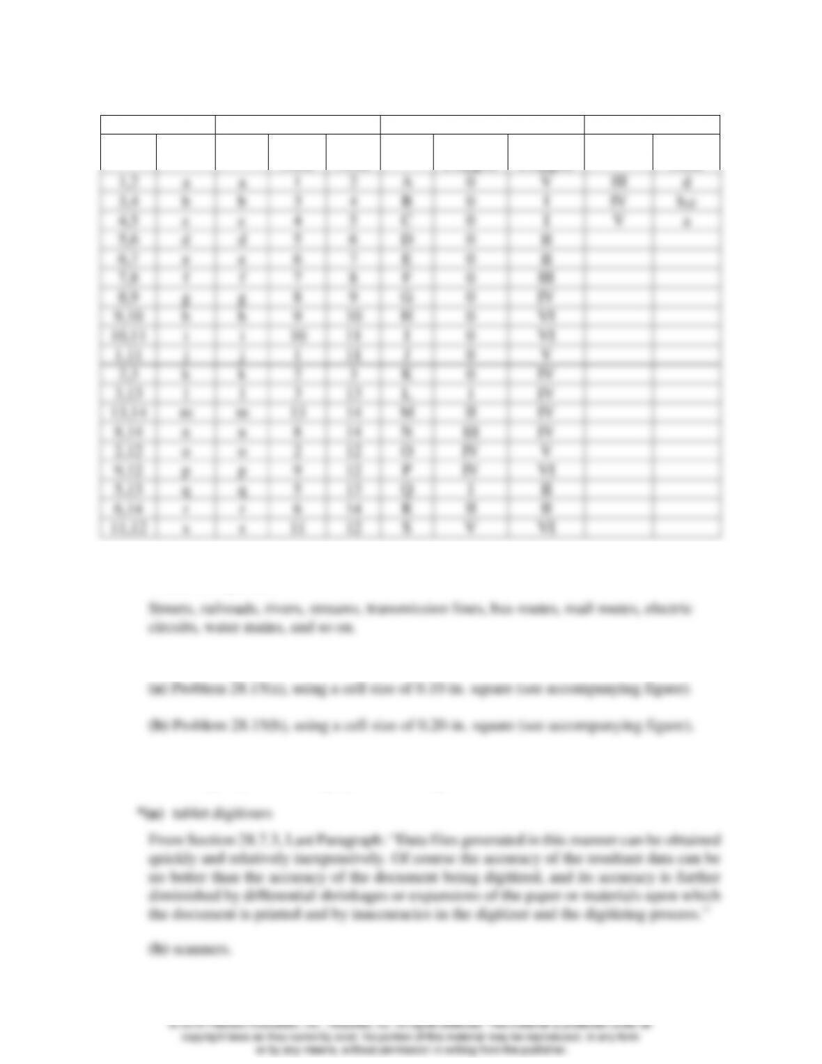
Connectivity
Direction
Adjacency
Nestedness
Nodes
Chains
Chain
From
Node
To
Node
Chain
Left
Polygon
Right
Polygon
Polygon
Nested
Node
1,2
a
a
1
2
A
0
V
III
d
3,4
b
b
3
4
B
0
I
IV
b,c
4,5
c
c
4
5
C
0
I
V
a
5,6
d
d
5
6
D
0
II
6,7
e
e
6
7
E
0
II
7,8
f
f
7
8
F
0
III
8,9
g
g
8
9
G
0
IV
9,10
h
h
9
10
H
0
VI
10,11
i
i
10
11
I
0
VI
1,11
j
j
1
11
J
0
V
2,3
k
k
2
3
K
0
IV
3,13
l
l
3
13
L
I
IV
13,14
m
m
13
14
M
II
IV
8,14
n
n
8
14
N
III
IV
2,12
o
o
2
12
O
IV
V
9,12
p
p
9
12
P
IV
VI
5,13
q
q
5
13
Q
I
II
6,14
r
r
6
14
R
II
II
11,12
s
s
11
12
S
V
VI
28.14 Compile a list of linear features for which the topological relationship of adjacency
would be important.
28.15 Prepare a raster (grid cell) representation of the sample map of:
28.16 Discuss the advantages and disadvantages of using the following equipment for
converting maps and other graphic data to digital form:

28.17 Explain the concepts of the following terms in GIS spatial analysis, and give an example
illustrating the beneficial application of each: (a) adjacency; and (b) connectivity.
28.18 If data were being represented in vector format, what simple spatial objects would be
associated with each of the following topological properties?
28.19 Prepare a transparency having a 0.10-in grid, overlay it onto Figure 28.4(a), and indicate
the grid cells that define the stream. Now convert this raster representation to vector
using the method described in Section 28.6.2. Repeat the process using a 0.20-in grid.
Compare the two resulting vector representations of the stream and explain any
differences.
Suggestion: If you have access to a scanner, scan Figure 28.4(a) and have the students
import it into their CAD package. Then set both the grid and snap to 0.1 and 0.2. and
© 2018 Pearson Education, Inc., Hoboken, NJ. All rights reserved. This material is protected under all

28.20 Discuss how spatial and non-spatial data are related in a GIS.
From Section 28.5, Paragraph 2: “In general, spatial data will have related nonspatial
28.21 What are the actual ground dimensions of a pixel for the following conditions:
28.22 Describe the following GIS functions, and give two examples where each would be
valuable in analysis:
(a) line buffering, and
From Section 28.9.1, Paragraph 2: “Line buffering, illustrated in Figure 28.10(b), creates
28.23 Go to the PASDA web site or a similar web site in your state and download an example
of:
(a) An orthophoto

28.24 Compile a list of data layers and attributes that would likely be included in an LIS.
28.25 Compile a list of data layers and attributes that would likely be included in a GIS for:
28.26 In Section 28.9.3, a flood-warning example is given to illustrate the value of
simultaneously applying more than one GIS analytical function. Describe another
example.
Answers will vary
28.27 Consult the literature on GISs and, based on your research, describe an example that
gives an application of a GIS in:
(a) Natural resource management
(b) Agriculture
(c) Engineering
(d) Forestry
Independent Project
© 2018 Pearson Education, Inc., Hoboken, NJ. All rights reserved. This material is protected under all

© 2018 Pearson Education, Inc., Hoboken, NJ. All rights reserved. This material is protected under all