
________ is the study of mineral materials.
A) Mineralogy
B) Lithology
C) Mineralosophy
D) Historical Geology
What is the source of the sediments in a forearc basin?
A) Carbonate reefs
B) Continental sediments and pyroclastic materials
C) Sediments washed from the landmass
D) Glacial sediments
What force pushes groundwater from pore space to pore space when below the water
table?
A) Gravity
B) Hydraulic gradient

C) Hydraulic conductivity
D) Artesian pressure
Which of the following statements about lava domes is true?
A) Lava domes can only collapse during eruptions.
B) Lava domes can collapse during eruptions or in quiet periods between eruptions.
C) Lava domes are most commonly associated with cinder cone volcanoes.
D) Lava domes are created by earthquakes.
A(n) ________ facies is associated with a high-pressure, low-temperature environment.
A) zeolite
B) granulite
C) blueschist
D) eclogite

Which of the following is an example of a speleothem?
A) Stalagmite
B) Sinkhole
C) Spring
D) Hot spring
Folds form in ________ temperature-________ pressure environments.
A) low-; low-
B) high-; high-
C) high-; low-
D) low-; high-
What is the asthenosphere?
A) A portion of the atmosphere that blocks UV radiation
B) A soft, low-velocity layer in the upper mantle
C) The transition zone between the mantle and the outer core
D) The portion of the hydrologic cycle that describes how plants contribute their
respiration
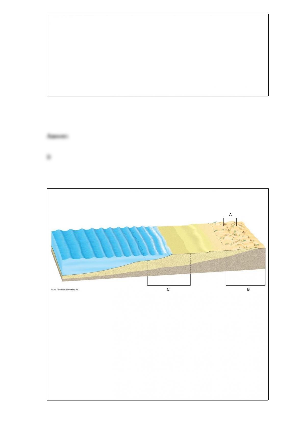
Identify the three missing terms from the diagram of the coastal area in this image.
A) Dunes
B) Foreshore
C) Coast
1. A
2. B
3. C

Match the type of tide/tidal pattern with the correct definition.
A) Two high tides of roughly the same height and two low tides of roughly the same
height each day
B) Highest high tides and lowest low tides of the month
C) Two high tides and two low tides each day, but with different high tide levels and
different low tide levels
D) Single high and single low tide every day
E) Highest low tides and lowest high tides of the month
1. Neap tide
2. Spring tide
3. Diurnal tidal pattern
4. Mixed tidal pattern
5. Semidiurnal tidal pattern

Along which tectonic boundary is ridge push going to be most important in helping to
drive plate motion?
A) Convergent boundary
B) Divergent boundary
C) Transform boundary
Which acid, found in most groundwater, is responsible for most karst topography
worldwide?
A) Hydrochloric
B) Nitric
C) Sulfuric
D) Carbonic

Which of the following desert landforms is carved from solid rock rather than
consisting of accumulated sediments?
A) Playa
B) Inselberg
C) Alluvial fan
D) Bajada
The Canadian province of Alberta has the world’s largest commercially developed
deposit of which fossil fuel?
A) Anthracite coal
B) Natural gas
C) Petroleum
D) Tar sands
Using the geologic cross section above, put the rock layers in order from oldest to
youngest. Use the blanks to the right of the figure for your answers.
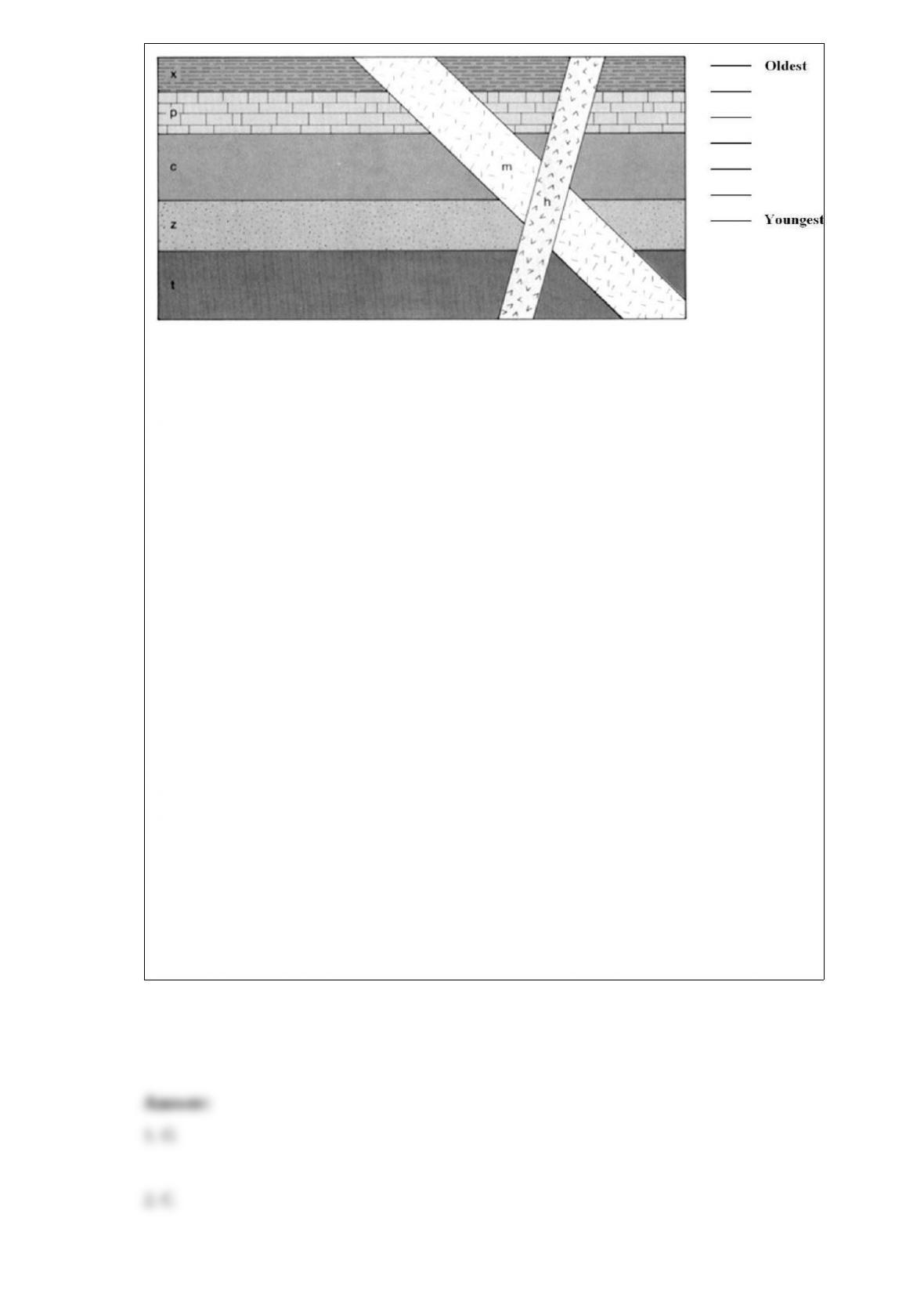
A) m
B) p
C) z
D) h
E) x
F) c
G) t
1. Oldest (top line)
2. Second line from the top
3. Third line from the top
4. Fourth line from the top
5. Third line from the bottom
6. Second line from the bottom
7. Youngest (bottom line)
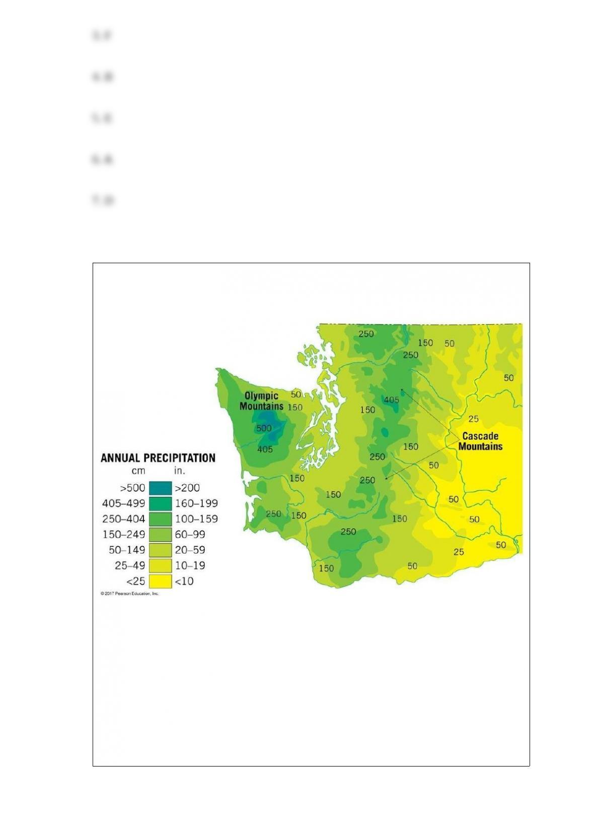
Based on the precipitation data available here, which region in Washington State would
be the most likely location of a rainshadow desert?
A) West in the Olympic Mountains
B) Southeastern Washington
C) Central Washington in the Cascade Mountains
D) Southwestern Washington
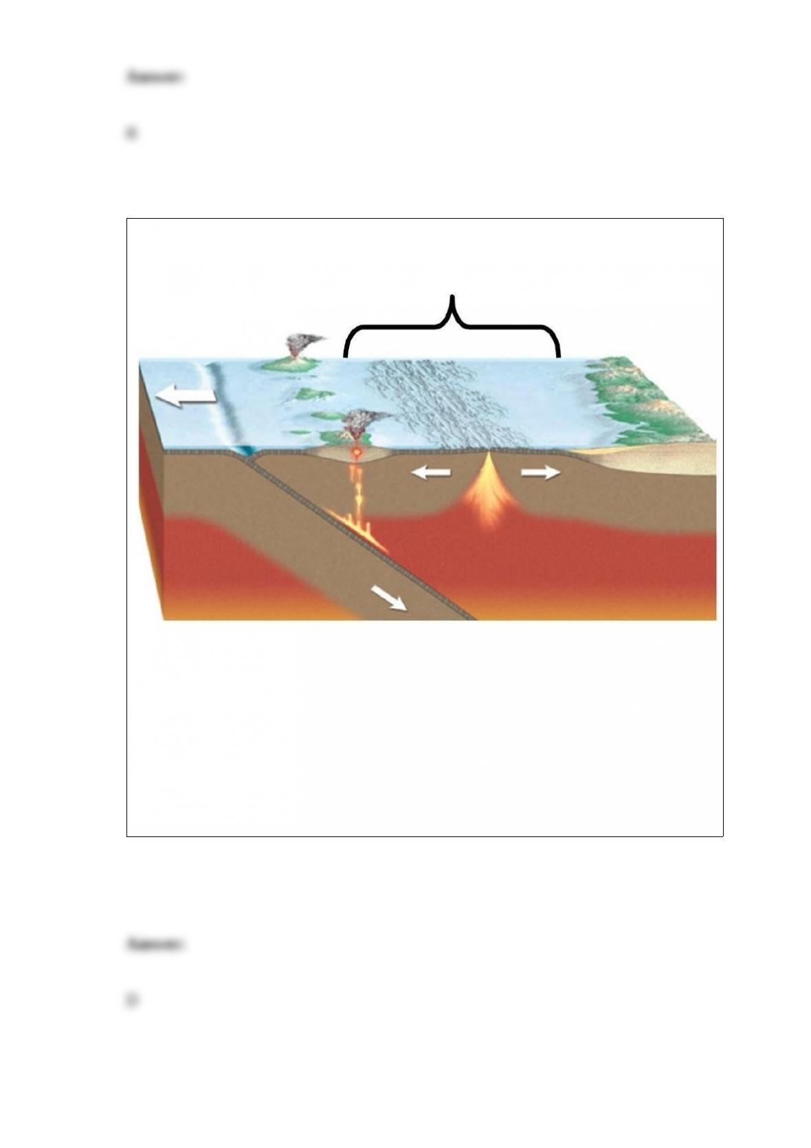
Which part of the subduction zone is indicated in this image?
A) Deep-ocean trench
B) Forearc basin
C) Volcanic arc
D) Back-arc basin
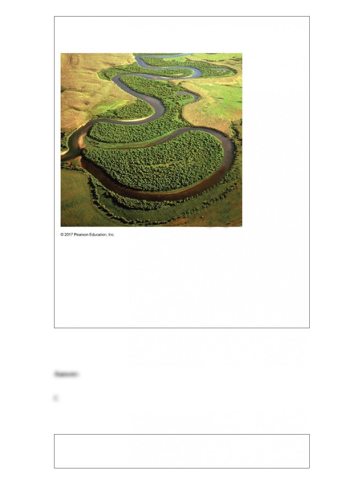
What kind of stream channel is visible here?
A) Laminar channel
B) Braided channel
C) Meandering channel
D) Overflow channel
What are the two primary sources for loess?
A) Lakes and streams

B) Deserts and glacial deposits
C) Atmosphere and volcanoes
D) Shallow seas and lakes
Which soil horizon can hold more water due to the accumulation of fine clay particles?
A) A horizon
B) B horizon
C) O horizon
D) E horizon
What is the definition of eluviation?
A) Decayed organic material
B) Accumulation of fine clay particles in a soil column
C) Downward transportation of fine clay particles in a soil column
D) The collective term for the O, A, E, and B horizons

A ________ stream consists of a complex network of converging and diverging
channels that weave around channel bars.
A) straight channel
B) meandering stream
C) braided stream
D) bedrock channel
________ weathering is most common in a desert environment.
A) Mechanical
B) Erosional
C) Chemical
D) Dissolution

Which of the following fossils fuels is the “cleanest” for the environment in the sense
that it is most likely to have the lowest sulfur content and the smallest volume of solid
ash residue?
A) Natural gas
B) Anthracite coal
C) Heavy, asphalitic crude oil
D) Lignite
Where is the top of the asthenosphere closest to Earth’s surface?
A) Along a mid-ocean ridge
B) Above a deep mantle plume
C) Along a transform fault
D) Along a subduction zone
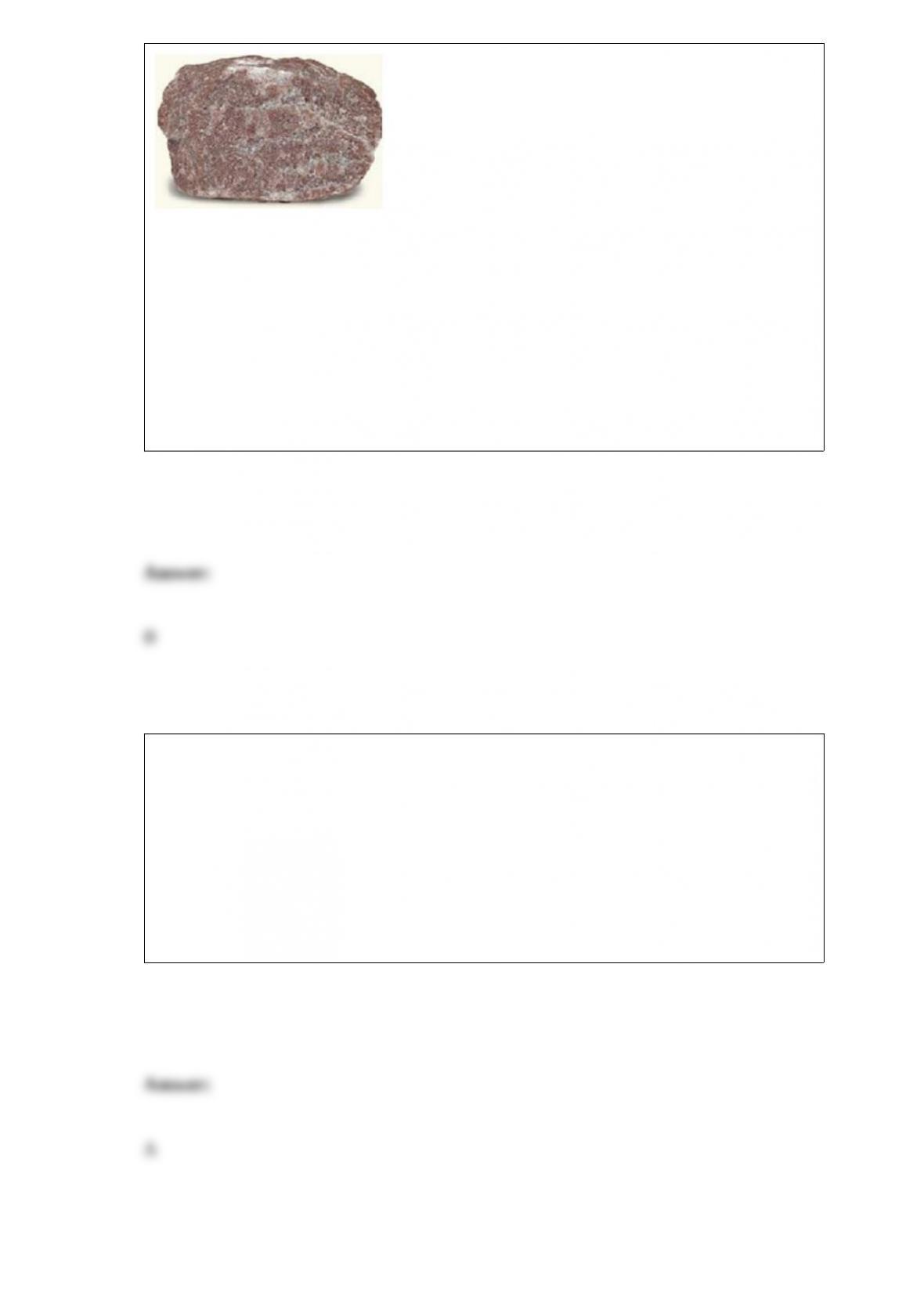
What is the name of this rock? (Hint: It can scratch glass.)
A) Slate
B) Quartzite
C) Marble
D) Gneiss
Which of the materials below is an example of biomass fuel?
A) Wood
B) Uranium
C) Oil
D) Hot water

Some of the most destructive earthquakes, such as the Haitian earthquake of 2010,
occur along ________ faults.
A) reverse
B) strike-slip
C) thrust
D) normal
The geologic rock cycle presents an orderly transition from igneous to sedimentary to
metamorphic rocks. However, there are also some alternative transitions that bypass
part of the rock cycle. Which of the following is the best example of one of those
bypasses?
A) Igneous rocks are weathered and eroded to become sediments.
B) Metamorphic rocks are melted to become magma.
C) Magma cools and crystallizes to form igneous rocks.
D) Sedimentary rocks are weathered into sediments, which become lithified into
sedimentary rocks.
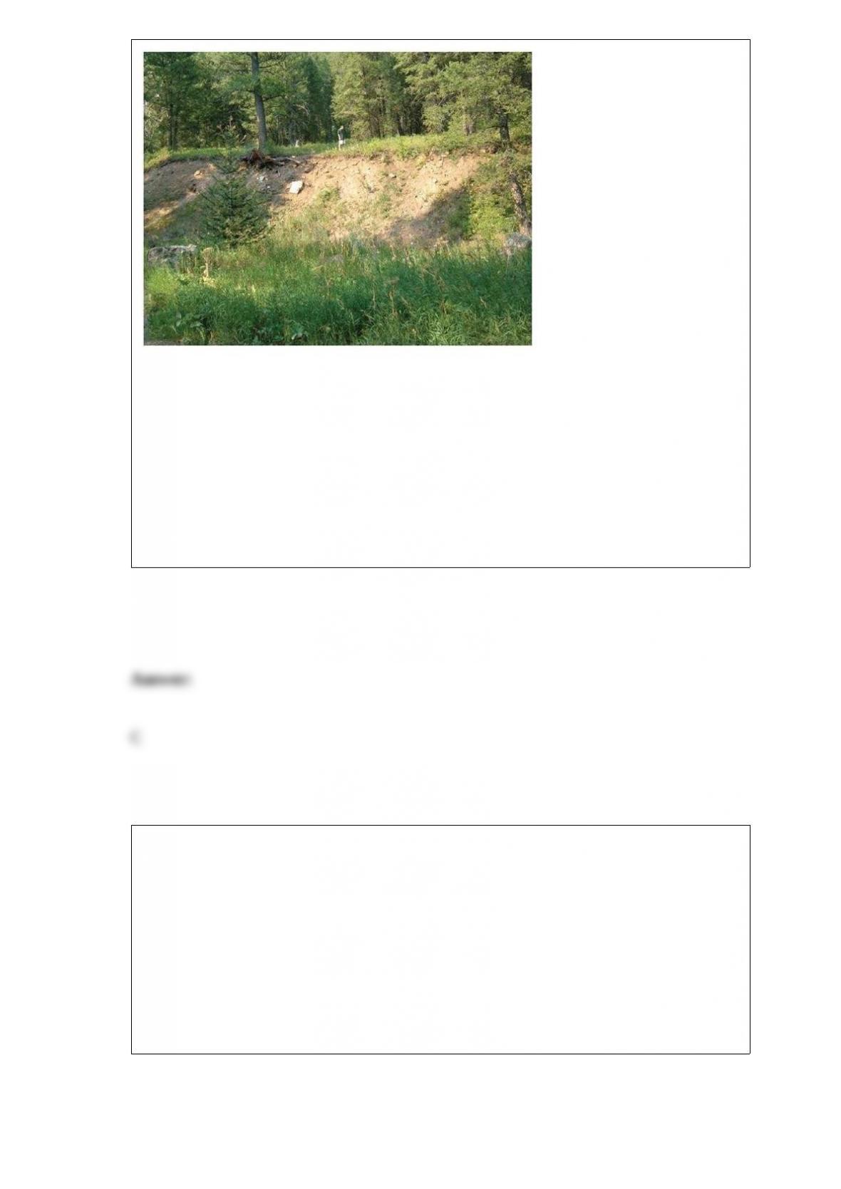
What feature, evidence of dip-slip activity, is shown in this image?
A) Anticline
B) Slickensides
C) Fault scarp
D) Joints
What is a craton?
A) The highly deformed, leading edge of a continent where subduction is occurring
B) The oldest part of a continent that has not been significantly deformed for 600
million years
C) An exotic terrane being accreted to a landmass
D) A down-dropped graben bounded by normal faults

Which horizons make up the solum?
A) C horizon
B) O and A horizons
C) E, B, and C horizons
D) O, A, E, and B horizons