
Globalization and Diversity, 5e (Rowntree et al.)
Chapter 3 North America
1) Which of the following statements is most accurate?
A) Canada is slightly smaller in land area than the United States, and its population is only about
10% that of the United States.
B) Canada is slightly smaller in land area than the United States, and its population is only about
20% that of the United States.
C) Canada is slightly larger in land area than the United States, but its population is only about
20% that of the United States.
D) Canada is slightly larger in land area than the United States, but its population is only about
11% that of the United States.
E) The United States and Canada have almost exactly the same land area, but the population of
the United States is double that of Canada.
2) Beneath which part of the United States is its largest aquifer, the Ogallala Aquifer, located?
A) the Pacific Northwest
B) New England
C) the Gulf Coast
D) the West Coast
E) the Great Plains

3) Which of these dams on the Colorado River that have decreased seasonal water flows is the
closest to the U.S./Mexico border?
A) Glen Canyon Dam
B) Hoover Dam
C) Parker Dam
D) Imperial Diversion Dam
E) Morelos Dam
4) Which North American region is complex, and is made up of drowned river valleys, bays,
swamps, and low barrier islands?
A) the West
B) the Piedmont
C) the Appalachian Highlands
D) the Atlantic coastline
E) the Gulf Coast
5) Which North American region lies west and north of the Piedmont and is an internally
complex zone of higher and rougher country reaching altitudes of 3,000-6,000 feet?
A) the Appalachian Highlands
B) the West
C) the Atlantic coastline
D) the Ozark Mountains
E) the Gulf Coast

6) What do we call the bioregion that is dominated by tall native grasslands, short grasses, or
scrub vegetation in North America?
A) boreal forest
B) desert
C) prairie
D) tundra
E) farmland
7) The Mexican environmental action group that joined with groups from the United States to
form a Green Coalition to reestablish the Colorado River delta was?
A) the Sonoran Institute
B) Defenders of Wildlife
C) the Environmental Defense Fund
D) the Central Arizona Project
E) Pronatura
8) The Athabasca Oil Sands, controversial because of planned long-distance pipelines near
environmentally sensitive areas, are located in
A) Alberta.
B) Oklahoma.
C) Texas.
D) British Columbia.
E) Saskatchewan.

9) What type of pollution is the greatest cause of acid rain?
A) industrial and auto emissions
B) agricultural pollutants
C) municipal waste
D) the generation of hydroelectric power
E) El Niño
10) In what region of the United States is the Piedmont located?
A) New England
B) the Southeast
C) the Midwest
D) the Intermountain West
E) the Pacific Northwest
11) Which North American region features mountain-building, alpine glaciation, and erosion?
A) the Atlantic coastline
B) the Piedmont
C) the West
D) the Appalachian Highlands
E) the Gulf Coast

12) Which North American region is the transition zone between nearby flat lowlands and steep
mountain slopes?
A) the West
B) the Atlantic coastline
C) the Appalachian Highlands
D) the Gulf Coast
E) the Piedmont
13) Which of the following factors greatly complicates the climate and vegetation patterns of
Western North America?
A) latitudinal range
B) the topography of mountains
C) size
D) rivers
E) deserts
14) As a consequence of climate change cruise ships will be able to use the Northwest Passage to
connect
A) San Francisco and Miami, Florida.
B) New York City and Anchorage, Alaska.
C) Toronto to the province of Nunavat.
D) the United States to Russia.
E) the Great Lakes to Hudson Bay.

15) The U.S. Census Bureau predicts that the 2050 population of North America will be
A) 265 million.
B) 395 million.
C) 464 million.
D) 500 million.
E) almost 1 billion.
16) Currently, how many people live in the North American Region?
A) 265 million
B) 295 million
C) 345 million
D) 500 million
E) 1 billion
17) The settlement of North America by Europeans took place in how many stages?
A) one
B) two
C) three
D) four
E) five

18) During which era of the Historical Evolution of the U.S. City did the city first develop a star-
shaped pattern?
A) Pedestrian/Horsecar era
B) Electric Streetcar era
C) Automobile era
D) Freeway era
E) Internet era
19) What region of the United States contains the country’s densest population settlement?
A) the Midwest
B) the Atlantic Coast
C) the Pacific Coast
D) the Sunbelt
E) the Great Plains
20) Megalopolis includes all of the following metropolitan areas EXCEPT
A) Baltimore/Washington, D.C.
B) Chicago.
C) Philadelphia.
D) New York City.
E) Boston.

21) What part of North America was settled last?
A) the St. Lawrence Valley
B) the San Francisco, California region
C) the Gulf Coast of the United States
D) the Plains provinces of Canada
E) the Upper Rio Grande Valley
22) The mechanization of farming has resulted in what recent migration trend?
A) westward movement of the population
B) the black exodus from the South
C) the growth of the Sun Belt South
D) rural–to-urban migration
E) nonmetropolitan growth
23) Cultural geographers estimate Native American populations in 1500 c.e. at ________ for the
continental United States and another 1.2 million for Canada, Alaska, Hawaii, and Greenland.
A) 2.8 million
B) 3.2 million
C) 4.2 million
D) 5.5 million
E) 8 million

24) Which of the following cities grew by about 26% between 2000 and 2010?
A) Los Angeles
B) Seattle
C) Minneapolis
D) Houston
E) Chicago
25) The regular rectangular look of vast portions of the North American interior is the result of
A) urban sprawl.
B) the creation of Central Business Districts.
C) new edge cities.
D) the township-and–range survey system.
E) urban decentralization.
26) Which of the following is NOT a consequence of urban sprawl?
A) population losses to inner cities
B) higher poverty rates in the inner cities
C) the relocation of industry to the inner cities
D) higher unemployment rates in the inner cities
E) increased racial tensions

27) Which of the following statements best describes North America’s population settlement
pattern?
A) Settlement is evenly distributed across the region.
B) Settlement follows waterways and inland lakes.
C) Settlement is strongly centered on large cities with more thinly settled areas in between.
D) Settlement is heavier in the western half of the region.
E) Settlement is heavier in the southern half of the United States and Canada than in the north.
28) Today in North America, many of the key internationally connected corporate offices,
industrial complexes, and entertainment facilities are located
A) in center cities.
B) in rural areas.
C) offshore.
D) in suburbs.
E) in primate cities.

29) During which era of the Historical Evolution of the U.S. City were cities compact, usually
about 3-4 miles in diameter?
A) Electric Streetcar era
B) Pedestrian/Horsecar era
C) Automobile era
D) Freeway era
E) Internet era
30) During which era of the Historical Evolution of the U.S. City did suburban growth begin?
A) Pedestrian/Horsecar era
B) Electric Streetcar era
C) Automobile era
D) Freeway era
E) Internet era
31) What do we call the situation wherein metropolitan areas sprawl in all directions and suburbs
take on many of the characteristics of traditional downtowns?
A) counterurbanization
B) concentric zones model
C) urban realms model
D) edge cities
E) urban decentralization
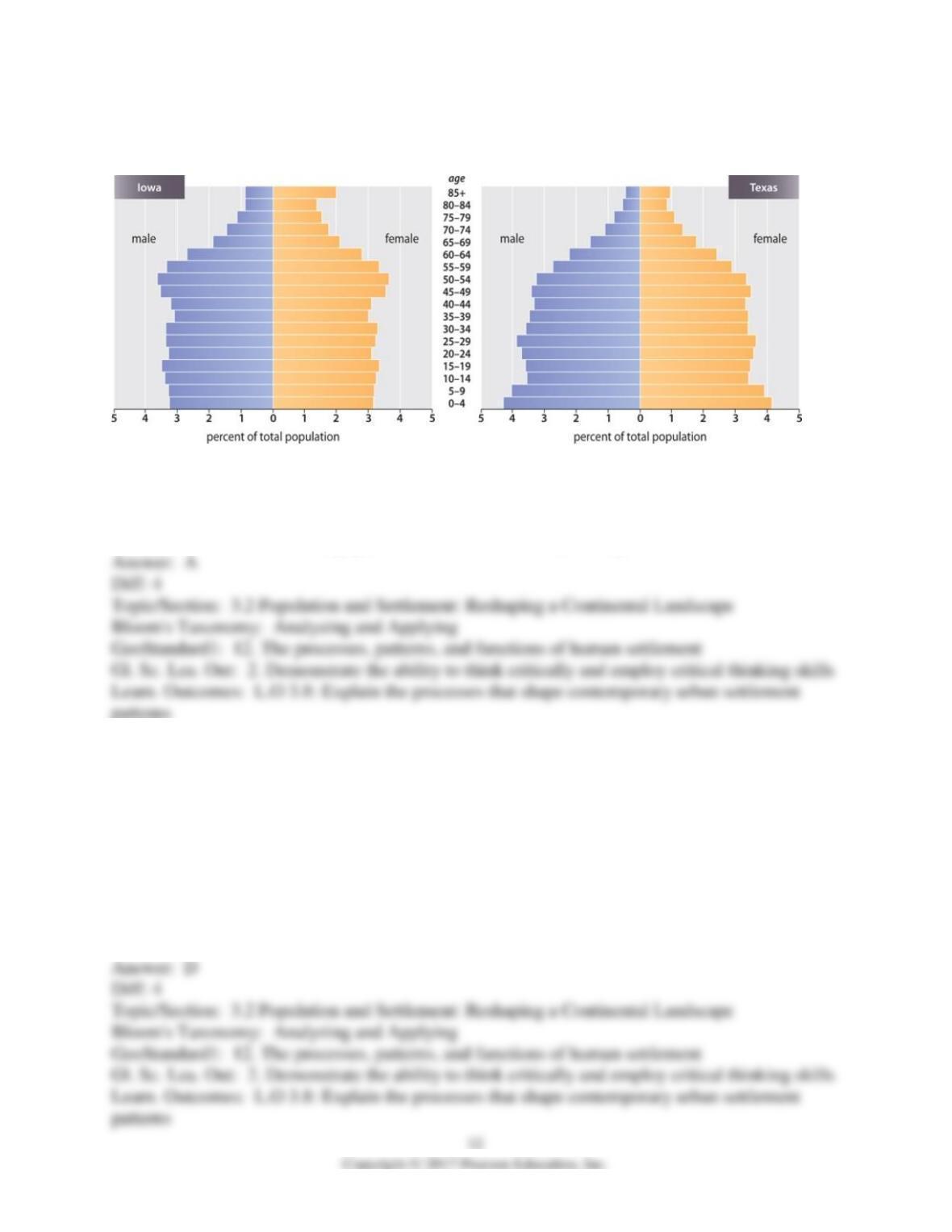
32) Using the graphic below, what is the primary difference between the populations of Iowa and
Texas?
A) The population of Iowa is older.
B) Texas has a much lower birth rate.
C) The influx of immigrants into Iowa is making the population younger.
D) Texas has a higher percentage of both older males and females.
E) There is no difference: the populations of the two states are nearly identical.
33) Which of the following statements is most accurate?
A) By 1990, more than half of the population of the United States lived west of the Colorado
River.
B) By 1990, more than half of the population of the United States lived west of the Rocky
Mountains.
C) In 1990, more than half of the population of the United States lived west of the Great Plains.
D) By 1990, more than half of the population of the United States lived west of the Mississippi
River.
E) By 1990, more than half of the population of the United States lived west of the Grand
Canyon.

34) During what period of time has the Sunbelt region of the United States grown most quickly?
A) 1970-present
B) 1950-1970
C) 1930-1950
D) 1910-1930
E) 1890-1910
35) Which of the following is NOT a reason why U.S. citizens have migrated to the Sunbelt
South?
A) government incentives
B) expanding economy
C) modest living costs
D) attractive recreational opportunities
E) adoption of air conditioning
36) Which of the following statements regarding ethnic populations in the United States is
LEAST accurate?
A) California has both the largest Hispanic population and the largest Asian population.
B) Nearly 60% of Canadian immigrants are Asian.
C) By 2050 nearly one in three Americans will be Hispanic.
D) The largest Asian ethnic group in the United States is the Chinese.
E) California has the largest Hispanic population, while New York has the largest Asian
population.

37) Settlement landscapes of North American cities are characterized by ________, in which
metropolitan areas sprawl in all directions and suburbs take on many of the characteristics of
traditional downtowns.
A) hierarchical diffusion
B) centripetal forces
C) gentrification
D) counterurbanization
E) urban decentralization
38) This is the process involving the displacement of lower-income residents of central–city
neighborhoods by higher-income residents, the improvement of deteriorated innercity
landscapes, and the construction of shopping complexes, sports and entertainment attractions,
and convention centers in selected downtown locations.
A) hierarchical diffusion
B) centripetal forces
C) gentrification
D) counterurbanization
E) urban decentralization

39) Which of the following is NOT a characteristic of gentrification?
A) the displacement of lower income residents by upper income residents
B) the rehabilitation of deteriorated inner-city landscapes
C) white flight to the suburbs
D) the construction of new shopping complexes
E) attraction of home-buyers to older, classic homes
40) During which era of the Historical Evolution of the U.S. City did more decentralized
settlement along commuter routes develop, in some cases as far away as 40–60 miles from
downtown?
A) Pedestrian/Horsecar era
B) Electric Streetcar era
C) Automobile era
D) Freeway era
E) Internet era