Exam
Name___________________________________
MULTIPLE CHOICE. Choose the one alternative that best completes the statement or answers the question.
1)
If there is a steeper pressure gradient, wind will be ________than areas with a gradual pressure
gradient.
1)
A)
stronger
B)
warmer
C)
cooler
D)
lighter
2)
Which of the following is an example of secondary circulation?
2)
A)
Mountain–valley breezes
B)
Weather patterns
C)
General circulation of the atmosphere
D)
Migratory high and low pressure systems
3)
On a weather map of air pressure, what can you infer from a close spacing of isobars?
3)
A)
Higher pressures
B)
A steep pressure gradient creating a slower flow of air
C)
A weak pressure gradient creating a slower flow of air
D)
Little without knowing temperature patterns
E)
A steep pressure gradient creating a faster flow of air
4)
Objects and wind moving over distance and time on Earth’s surface are
4)
A)
always deflected to the right by the friction force.
B)
affected only by the pressure gradient and friction force.
C)
always deflected from a straight path to the west in the Southern Hemisphere.
D)
apparently deflected from a straight path to the right in the Northern Hemisphere.
5)
An instrument used to measure air pressure is
5)
A)
an anemometer.
B)
an aneroid barometer.
C)
a mercury thermometer.
D)
a wind vane.
6)
The wind converging at the equatorial low are known as
6)
A)
polar easterlies.
B)
doldrums.
C)
westerlies.
D)
trade winds.
D
7)
In the absence of friction, the combined effect of the Coriolis force and the pressure gradient force
produces
7)
A)
air flow in a north–south direction.
B)
surface winds.
C)
geostrophic winds at altitudes above the ground.
D)
air flow from low to high pressure centers.
E)
air flow perpendicular to the isobars.
C
8)
In the Northern Hemisphere, ocean currents move ________ about high–pressure cells; in the
Southern Hemisphere ocean currents move ________ about high–pressure cells.
8)
A)
perpendicular; parallel
B)
counterclockwise; clockwise
C)
clockwise; counterclockwise
D)
parallel; perpendicular
C
B
9)
Which is TRUE of upper atmospheric circulation?
9)
A)
It refers to the winds in the thermosphere.
B)
These winds are unrelated to surface weather patterns and of no consequence to the
atmosphere‘s general circulation.
C)
These winds flow principally from the east. in the mesosphere.
D)
Middle and upper tropospheric circulation is an important component of the atmosphere’s
general circulation.
10)
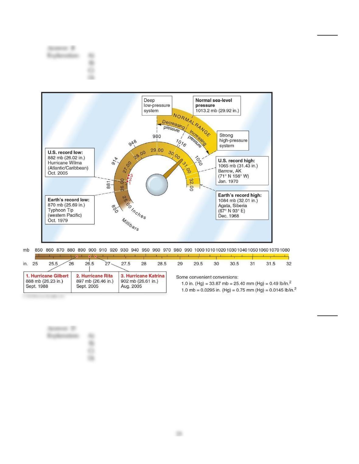
Normal sea level pressure has a value of
10)
A)
500 mb.
B)
32.01 millibars of mercury.
C)
28.50 inches of lead.
D)
1013.2 millibars.
Explanation:
11)
Which of the following is TRUE of deep water currents associated with thermohaline circulation?
11)
A)
They are deep currents caused by differences in temperature and salinity.
B)
They travel at greater speeds than surface currents.
C)
They are largely wind driven.
D)
Due to t heir depths, they carry limited volumes of water.
Explanation:
12)
Which of the following is an example of tertiary circulation?
12)
A)
Migratory high and low pressure systems
B)
Subtropical high pressure systems
C)
Land–sea breezes
D)
General circulation of the atmosphere
Explanation:
Explanation:
13)
Which of the following is associated with an ENSO event?
13)
A)
Cooler than normal sea surface tempatures along the western South American coast.
B)
Enhanced upwelling in the Humboldt (Peru) current.
C)
Increased thermocline in the eastern Pacific.
D)
Higher pressure over the western Pacific and lower pressure over the eastern Pacific.
14)
An aircraft altimeter is a type of
14)
A)
aneroid barometer.
B)
anemometer.
C)
mercury barometer.
D)
hygrometer.
E)
sextant.
15)
Which of the following is TRUE of high pressure areas?
15)
A)
Air converges and ascends within high pressure systems.
B)
They are characteristic for areas along the equator.
C)
They generally involve atmospheric pressures lower than 1000 mb.
D)
Air descends and diverges within high pressure systems.
16)
Mountain and valley breezes
16)
A)
are caused by valley floors heating more quickly than valley slopes during the day and
cooling more rapidly at night.
B)
are characterized by warmer air descending mountain slopes during the day and valley air
ascending the mountain slopes at night.
C)
are secondary wind systems.
D)
involve warm air rising upslope during the day, creating an area of low pressure; whereas, at
night cool air forms and descends downslope with a lower pressure area on the valley floor.
17)
If surface winds were influenced only by the pressure gradient force and Coriolis force (i.e.without
the frictional force)
17)
A)
winds would flow in a straight line from areas of higher to lower pressure.
B)
there would be no winds at all.
C)
winds would flow parallel to isobars and at high rates of speed.
D)
The effects would vary depending on surface texture.
18)
An aneroid barometer
18)
A)
is a hypothetical instrument for measuring air pressure.
B)
requires the use of mercury.
C)
uses a meter long tube for measuring air pressure.
D)
uses a chamber that expands or contracts with changes in air pressure.
19)
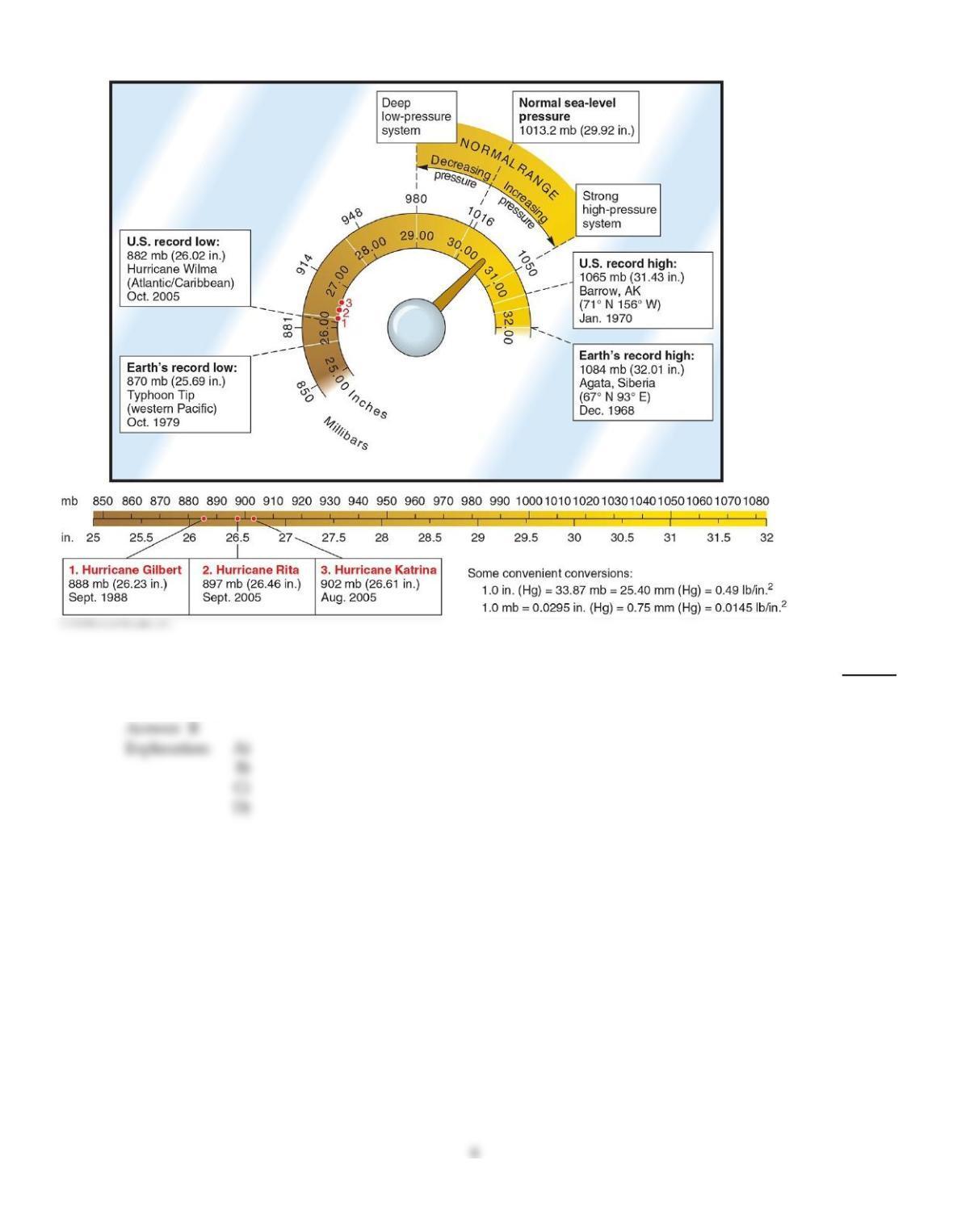
The highest surface air pressure ever recorded occurred when the air was
19)
A)
very wet.
B)
very cold.
C)
very high above the surface of Earth.
D)
very warm.
20)
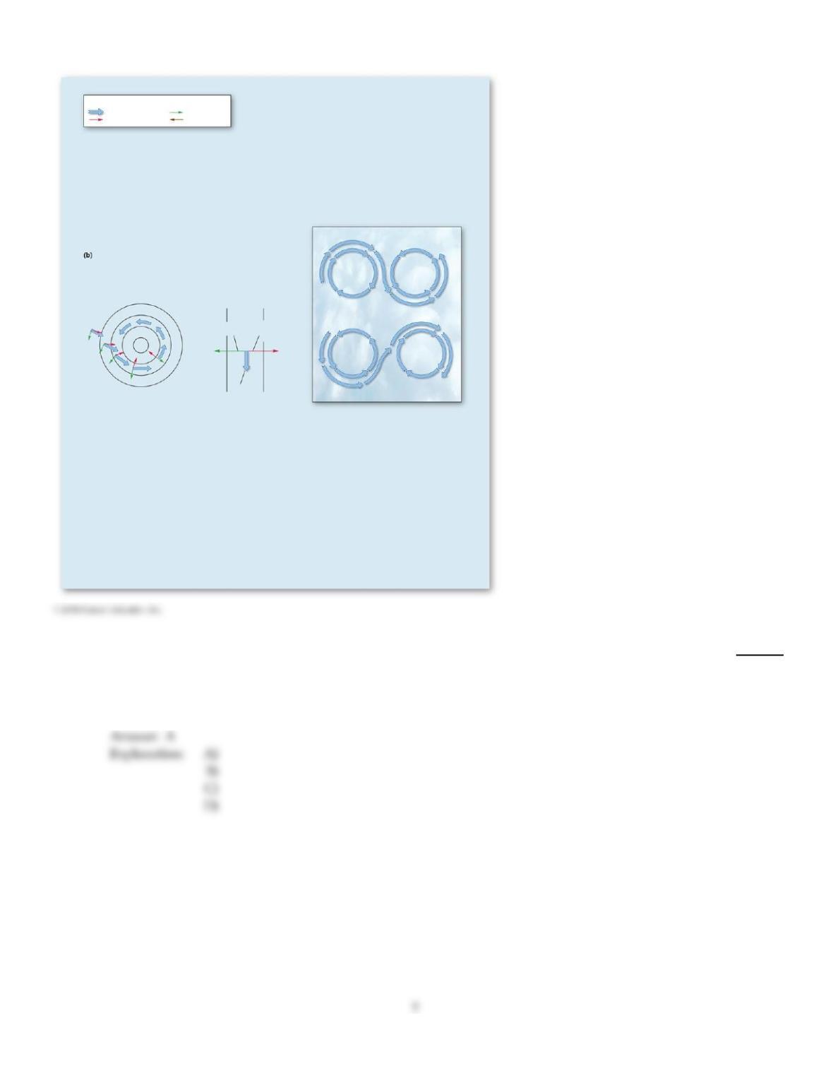
The figure is an example of
20)
A)
geostrophic winds.
B)
wind movement based on the pressure gradient force alone.
C)
A high pressure center (anticyclone).
D)
winds influenced by both the pressure gradient and Coriolis forces.
21)
Which of the following is TRUE regarding low–pressure cells in the Southern Hemisphere?
21)
A)
They form a continuous belt of uniform intensity surrounding the periphery of Antarctica.
B)
They are most strongly developed during the summer months (January).
C)
They are influenced by continental–sized land areas at 60° S latitude.
D)
The air circulation pattern around each low is clockwise.
22)
The Coriolis force
22)
A)
drives air from areas of higher to lower barometric pressure.
B)
causes the apparent deflection of winds from a straight path.
C)
is the only force acting on flows of air in the upper troposphere.
D)
decreases with height above the surface.
23)
Which association is INCORRECT?
23)
A)
Polar High Cold/Dry
B)
Equatorial low Hot/Dry
C)
Subpolar low 60° N/S
D)
Subtropical High 20–35° N/S
24)
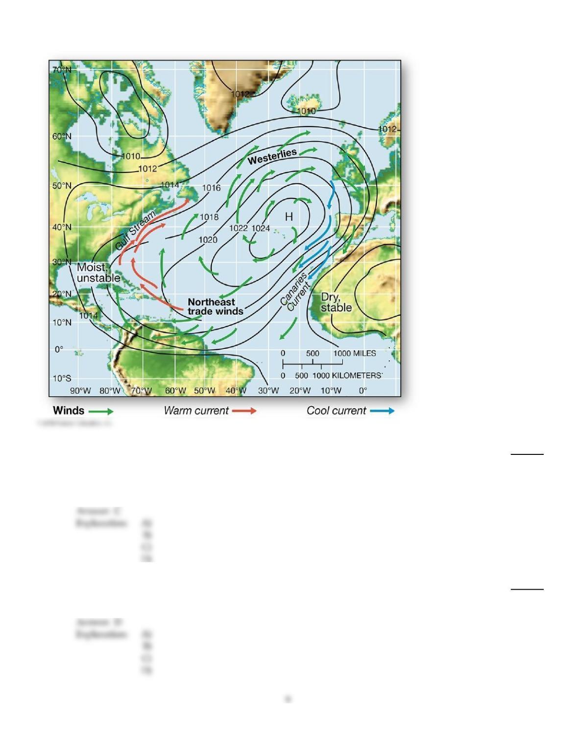
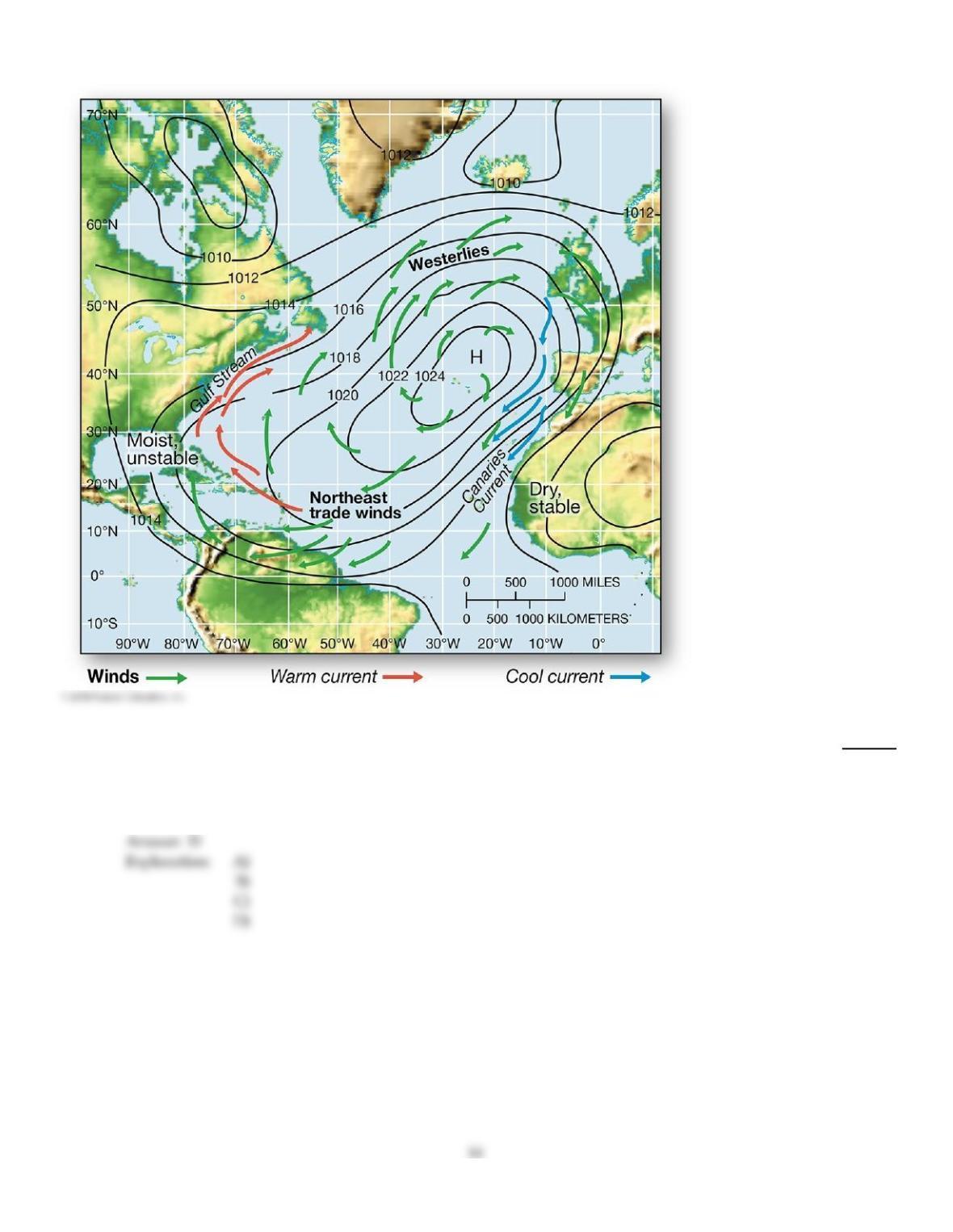
The subtropical high pressure system in the North Atlantic and associated cool and warm currents
24)
A)
influence the warm and dry conditions in the Bahamas.
B)
circulate warm ocean currents along the western African coast.
C)
contribute to west African deserts (dry, stable climate)
D)
bring cool waters to the eastern shores of the United States.
25)
A(n) ________ is an instrument used to measure wind speed.
25)
A)
wind vane
B)
sling psychrometer
C)
barometer
D)
anemometer
Explanation:
Explanation:
26)
Which of the following is an example of primary circulation?
26)
A)
Migratory high and low pressure systems
B)
General circulation of the atmosphere
C)
Land–sea breezes
D)
The monsoons
27)
Katabatic winds are
27)
A)
regional–scale, gravity–driven winds that bring high density air downslope.
B)
localized winds associated with sea–breezes.
C)
unrelated to pressure differences.
D)
another name for mountain–valley breezes.
Explanation:
28)
The average height of a column of mercury (Hg) in a barometer at sea level is
28)
A)
something that can not be determined without knowing air temperature.
B)
29.00 millibars.
C)
1013 inches.
D)
760 mm (76 cm).
Explanation:
29)
Which of the following matches is INCORRECT relative to air circulation?
29)
A)
Cyclone = low pressure center
B)
Anticyclone = high pressure center
C)
Anticyclone = clockwise circulation in the Southern Hemisphere
D)
Cyclone = counterclockwise in the Northern Hemisphere
Explanation:
30)
If you were between 40° and 50° north latitude, and you wanted to stand with the average winds
blowing in your face you would stand facing
30)
A)
south.
B)
east.
C)
west.
D)
north.
Explanation:
Explanation:
31)
Monsoonal winds are
31)
A)
a form of mountain–valley wind.
B)
regional wind systems vary seasonally.
C)
limited to the Indian subcontinent.
D)
katabatic in nature.
32)
Which of the following is FALSE as regards the jet streams?
32)
A)
They have no known effect on surface weather systems.
B)
They weaken during each of the hemisphere’s summer and strengthen during its winter.
C)
They occur above the subtropics and the polar front.
D)
The highest velocities occurring toward the core of the jet streams
33)
Which of the following primary pressure areas are produced by thermal factors, rather than
dynamic factors?
33)
A)
Equatorial low and Bermuda high
B)
Aleutian low and Icelandic low
C)
Subtropical high and subpolar low
D)
Equatorial low and polar high
34)
Which of the following is associated with deserts such as the Sahara or the Arabian Desert?
34)
A)
Major agricultural regions
B)
World’s equatorial rain forests
C)
Subtropical high pressure
D)
Subpolar lows
35)
A monsoon climate is characterized by ________ summers and ________ winters.
35)
A)
wet; wet
B)
wet; dry
C)
dry; wet
D)
dry; dry
36)
Air flow in a Northern Hemisphere high pressure zone is
36)
A)
downward, outward and counterclockwise.
B)
inward, upward and counterclockwise.
C)
downward, outward and clockwise.
D)
downward, inward and clockwise.
E)
inward, upward and clockwise.
37)
Which is TRUE of air flowing into low pressure center?
37)
A)
Air converges and ascends.
B)
Air diverges and descends.
C)
Air diverges and ascends.
D)
Air converges and descends.
A
38)
The intertropical convergence zone (ITCZ) is associated with
38)
A)
the horse latitudes.
B)
subtropical high–pressure development.
C)
the principal midlatitude circulations.
D)
the equatorial low–pressure trough.
D
39)
Which of the following are CORRECTLY matched?
39)
A)
High pressure ascending, converging air movements
B)
Cyclones low pressure cells
C)
Anticyclones subpolar pressure cells
D)
High pressure cells cyclonic circulation
B
C
40)
Which of the following is NOT true of the wind?
40)
A)
It blows from regions of high pressure to regions of low pressure.
B)
Air blows from regions of hotter air to regions of colder air.
C)
Winds are named based on the direction from which they blow.
D)
The direction of flow can be affected by the rotation of Earth.
E)
It is initiated by the pressure gradient force.
41)
The El Niño–Southern Oscillation is associated with the following EXCEPT
41)
A)
heavy precipitation in the southwest United States, Bolivia, Cuba, Ecuador, and Peru
B)
drought in South Africa, southern India, Australia, and the Philippines.
C)
cooler than normal ocean along the west coast of South America
D)
higher pressure than normal over the western Pacific and lower pressure over the eastern
Pacific.
42)
The western side of subtropical high pressure cells tend to be
42)
A)
dry, stable, and warm, with cooler ocean currents.
B)
cool and moist.
C)
generally in the same position all year; i.e., they do not migrate with the high Sun.
D)
warm, moist, and unstable.
43)
Sea–breezes
43)
A)
occur because warmer air is denser and settles to the surface of the land.
B)
result from water heating and cooling faster than land surfaces.
C)
form because of higher pressure over the land than the sea.
D)
involve onshore (toward the land) air flows that develop in the afternoon.
44)
Light and variable windswhich caused difficulties for mariners in the days of sailing shipsoccur
under the
44)
A)
equatorial low and subpolar low.
B)
subpolar low and subtropical high.
C)
subpolar low and equatorial low.
D)
equatorial low and subtropical high.
45)
The El Niño–Southern Oscillation
45)
A)
A north–south fluctuation of high and low pressure zones in the North Atlantic Ocean.
B)
occurs every year around Christmas time in the southern Pacific Ocean.
C)
is a pattern of sea surface, air pressure, and wind shifts between the northern and tropical
western Pacific.
D)
is a periodic shift of high and low pressure zones over the western and eastern Pacific,
respectively, usually occurring every 2 to 12 years.
46)
The most prominent movement in the upper–level westerly geostrophic wind flows are the
46)
A)
anticyclones.
B)
jet streams.
C)
katabatic waves.
D)
cyclones.
47)
Trade winds drive ocean surface waters
47)
A)
northward.
B)
eastward.
C)
southward.
D)
westward.
48)
Upper tropospheric winds that flow parallel to isobars are called
48)
A)
westerlies.
B)
geostrophic winds
C)
NE trades winds.
D)
easterlies.
49)
Within the United States, the areas best suited for wind energy development are
49)
A)
the South, particular along the Florida peninsula.
B)
the West Coast.
C)
the Great Plains (central U.S.).
D)
the Appalachian Mountains.
E)
the East Coast.
50)
If Earth did not rotate, air would flow
50)
A)
to the right of its direction of motion in the Northern Hemisphere.
B)
perpendicular to the isobars, i.e., straight across the isobars.
C)
parallel to the isobars.
D)
to the left of its direction of motion in the Northern Hemisphere.
51)
Zones of windless, hot, dry desert air between 25° N and 25° S latitude are named
51)
A)
westerlies.
B)
the doldrums.
C)
the horse latitudes.
D)
Hadley cells.
52)
________ is used in a barometer because ________.
52)
A)
Mercury; it is denser than water
B)
Mercury; it will rise more than water will under the same air pressure
C)
Water; it is liquid at normal air temperature
D)
Water; it is denser than mercury
53)
Which of the following is NOT true of the polar front zone?
53)
A)
It is a zone in which warm and cold air mix.
B)
There is little precipitation in the zone.
C)
The polar jet stream is usually located above it.
D)
It is a zone of frequently strong winds.
B
54)
________ are waving undulations within the upper–air westerly wind flow.
54)
A)
The trade winds
B)
Monsoons
C)
Rossby waves
D)
Hadley cells
C
55)
If Santa flew from the North Pole due south along the 100° meridian and did not correct his course,
he would land
55)
A)
west of the 100° meridian.
B)
on the 100° meridian.
C)
south of the 100° meridian.
D)
east of the 100° meridian.
A
56)
Which of the following matches is CORRECT relative to air circulation?
56)
A)
Anticyclone = low pressure center
B)
Anticyclone = counterclockwise circulation in the Northern Hemisphere
C)
Cyclone = clockwise circulation in the Southern Hemisphere
D)
Cyclone = high pressure center
C
A
57)
A(n) ________ is an instrument used to measure wind direction.
57)
A)
wind vane
B)
sling psychrometer
C)
anemometer
D)
barometer
58)
Which of the following is NOT true about electricity generated by wind?
58)
A)
There are numerous economic and social benefits associated with wind energy.
B)
It is non–renewable and has been linked to adverse human health effects.
C)
Turbines have been installed in over 81 countries.
D)
It is cost–competitive with electricity generated by coal, oil, and nuclear.
E)
It could help reduce carbon dioxide emissions.
Explanation:
59)
The western intensification causes water to pile up ________, forcing it to flow ________ in strong
currents.
59)
A)
along western shores of continents; downward, then eastward
B)
around the subtropical highs; in all directions
C)
at the equator; eastward and westward
D)
against eastern shore of continents; northward and southward
Explanation:
60)
During the day along the coast, the wind tends to blow toward the ________ because ________.
60)
A)
land; land heats more slowly than water
B)
water; water heats more rapidly than land
C)
water; water heats more slowly than land
D)
land; land heats more rapidly than water
Explanation:
Explanation:
61)
Winds that blow predominantly from the northeast and the southeast are the
61)
A)
westerlies.
B)
polar easterlies.
C)
trade winds.
D)
horse latitudes.
62)
Which of the following describes the pressure gradient force?
62)
A)
It decreases with height above the surface.
B)
It drives air from areas of higher to lower barometric pressure.
C)
It is the only force acting on atmospheric flows in the upper troposphere.
D)
It causes apparent deflection of winds from a straight path.
63)
Which of the following is TRUE regarding the effects of the Coriolis force?
63)
A)
The amount of Coriolis deflection is uniform from equator to poles.
B)
The Coriolis force is zero along the equator, increasing to one–half of maximum at 30°
latitude and maximum at the poles.
C)
Coriolis deflection occurs only along parallels, not meridians.
D)
The Coriolis force is zero at the poles, increasing to maximum along the equator.
64)
The tropical atmospheric circulation associated with rising winds along the intertropical
convergence zone (ITCZ) and descending air in the subtropics are called
64)
A)
Rossby waves.
B)
Ferrel cells.
C)
polar cells.
D)
Hadley cells.
65)
Evangelista Torricelli, a pupil of Galileo, determined that
65)
A)
atmospheric pressure is uniform in the troposphere.
B)
large–scale circulations of winds.
C)
winds flow from airs of high to low pressure.
D)
air pressure varied with weather conditions.
66)
Which of the following is NOT important in shaping ocean currents?
66)
A)
Configuration of continents and the ocean floor.
B)
The frictional drag of winds.
C)
The Coriolis force and water density differences
D)
Land–sea breezes.
67)
On Earth between 30° north latitude and the equator, winds flow from the ________ as they flow
out of the ________ pressure zone toward the ITCZ.
67)
A)
NW; subtropical high
B)
SE; subtropical high
C)
NE; polar high
D)
SW; subtropical high
E)
NE; subtropical high
Explanation:
68)
Which of the following is NOT true regarding the effects of the 1991 Mount Pinatubo eruption?
68)
A)
A small, temporary decrease in average temperatures followed.
B)
Aerosols mixed with other atmospheric debris, increasing Earth’s albedo.
C)
An aerosol cloud covered the globe, from 20° S to 30° N.
D)
Sulfur dioxide (SO2) aerosols decreased in the atmosphere due to the presence of ash.
Explanation:
69)
As of 2012, which country had the highest installed wind energy capacity?
69)
A)
Ethiopia
B)
China
C)
The United States
D)
El Salvador
E)
Germany
Explanation:
Explanation:
70)
Calm winds associated with a weak pressure gradient and the vertical ascent of air in the ITCZ are
known as
70)
A)
westerlies.
B)
Hadley cells.
C)
the horse latitudes.
D)
the doldrums
71)
The frictional force effect on winds
71)
A)
is constant, regardless of time of day or year.
B)
is negligible at altitudes above 500 m (~1,600 ft).
C)
is lessened in areas with rougher surfaces.
D)
increases with increasing altitude.
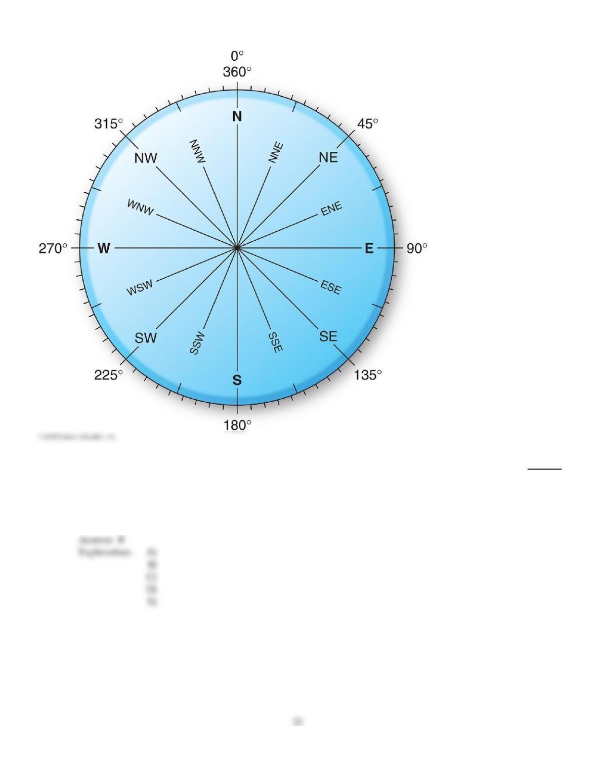
72)
If a wind is blowing from a compass direction of 202.5°, the wind is from the
72)
A)
north–northeast (NNE).
B)
south–southwest (SSW).
C)
north (N).
D)
south (S).
E)
northwest (NW).
73)
Dry, warm downslope winds occurring on the leeward side of Cascades and Rockies are called
73)
A)
mistrals.
B)
chinooks.
C)
takus.
D)
boras.
74)
The normal range for air pressure at sea level is
74)
A)
500 to 1000 mb.
B)
100 to 650 mb.
C)
1060–2010 mb.
D)
980–1050 mb.
75)
The polar high pressure cells
75)
A)
produce the weak, variable polar easterlies.
B)
are more pronounced at the North Pole than at the South Pole.
C)
are cyclonic in nature.
D)
are the strongest of the four primary pressure areas.
76)
Which of the following is TRUE of India’s weather patterns?
76)
A)
Dry winds desiccate the land during each summer.
B)
They are characterized by an even distribution of precipitation throughout the year.
C)
Monsoonal rains are heaviest in winter from December to February.
D)
The shifting of the intertropical convergence zone and upper air circulation brings heavy
precipitation in summer from June to September.
77)
An isoline of equal pressure plotted on a weather map is known as an
77)
A)
isotherm.
B)
isobar.
C)
isohyet.
D)
equilibrium line.
78)
Which of the following is NOT a determinant of wind speed and direction?
78)
A)
Gravitational force
B)
Pressure gradient force
C)
Coriolis force
D)
Friction force
E)
Electromagnetic force
79)
Which of the following primary pressure areas are produced by dynamic factors, rather than
thermal factors?
79)
A)
Equatorial low and polar high
B)
Equatorial low and Bermuda high
C)
Aleutian low and Icelandic low
D)
Subtropical high and subpolar low
80)
Which of the following is INCORRECT regarding the subpolar low–pressure cells?
80)
A)
In the Northern Hemisphere, they are generally stronger in summer than in winter.
B)
They develop more strongly over the ocean than over land.
C)
They are associated with the polar front.
D)
They are known as the Aleutian and Icelandic lows.
81)
Santa Ana winds
81)
A)
bring cool, moisture–laden air from the east to the southern California coast.
B)
flows from lower to higher elevation, expanding and cooling in the process.
C)
create wildfire conditions by bringing heat and dryness as they flow southwest.
D)
are not associated with pressure gradients in the way other winds are.
82)
Which of the following is NOT true of the intertropical convergence zone (ITCZ)?
82)
A)
The ITCZ is stationary throughout the year.
B)
Warm, moisture–laden airs converge along the ITCZ.
C)
A band of precipitation is associated with the ITCZ.
D)
Consistent high Sun altitude and daylength make large amounts of energy available.
83)
The great circulations in the ocean basins occur around the ________ pressure systems and are
known as ________.
83)
A)
subtropical high; gyres
B)
subpolar low; gyres
C)
subpolar low; ocean streams
D)
subtropical high; ocean streams
84)
Seasonally shifting wind systems associated with the annual cycle of returning precipitation are
known as
84)
A)
sea breezes.
B)
monsoons.
C)
Santa Ana winds.
D)
chinook winds.
B
85)
Which of the following is NOT associated with the Asian monsoon pattern?
85)
A)
High amounts of precipitation, including record breaking rainfall.
B)
Unequal heating between the Asian landmass and Indian Ocean.
C)
Shifting migration of the ITCZ bringing moisture–laden air to the area during the summer.
D)
Summer low pressure zones over the ocean and high pressure zone over land.
D
86)
During the winter, the Bermuda high migrates to the ________ and becomes the ________.
86)
A)
east; Aleutian low
B)
west; Pacific high
C)
west; Aleutian low
D)
east; Azores high
E)
west; Azores high
D
A
87)
Which of the following would cause the Coriolis force to increase?
87)
A)
Occurrence closer to the equator.
B)
Increase in friction.
C)
Increase in wind speed.
D)
Movement over very small areas.
88)
The deflection produced by the Coriolis force is caused by
88)
A)
Earth’s rotation on its axis.
B)
friction caused by gravitational force.
C)
air temperature differences.
D)
differing pressure gradients.
89)
An increase in air pressure will cause the mercury in a barometer to
89)
A)
boil.
B)
rise.
C)
fall.
D)
freeze.
90)
In the Northern Hemispheres, winds spiraling clockwise out of a high pressure area are
90)
A)
cyclonic.
B)
geostrophic.
C)
anticyclonic.
D)
meridional.
91)
In the Northern Hemispheres, winds spiraling counterclockwise into a low pressure area are
91)
A)
cyclonic.
B)
meridional.
C)
geostrophic.
D)
anticyclonic.
92)
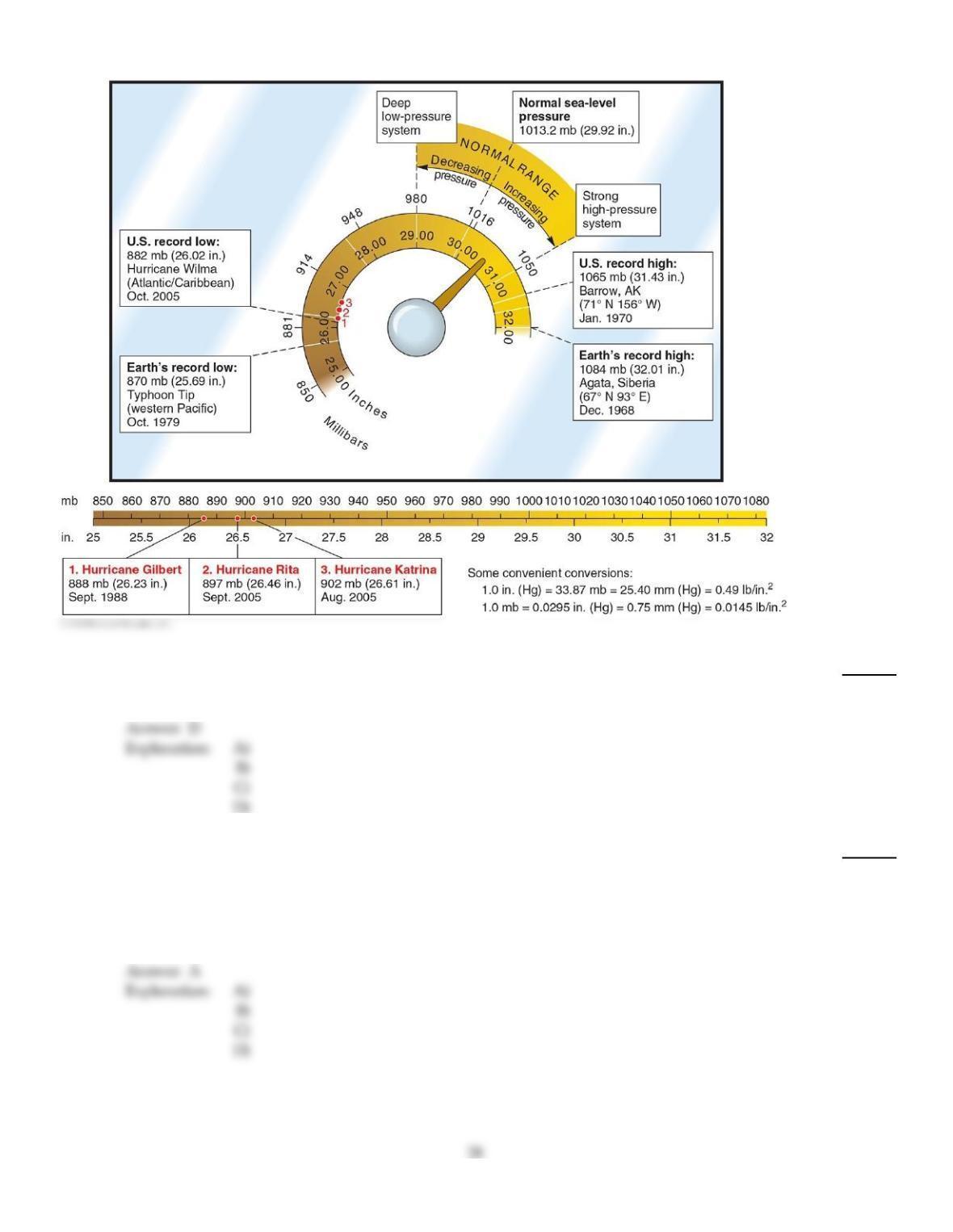
The lowest surface air pressures ever recorded are associated with
92)
A)
frontal systems (cold and warm fronts).
B)
sea level.
C)
cold and dry climates.
D)
hurricanes (typhoons).
93)
On Earth between 30° and 60° north latitude, winds flow from the ________ as they flow out of the
________ pressure zone toward the ________ pressure zone.
93)
A)
west–southwest; subtropical high; subpolar low
B)
west–southwest; subpolar low; subtropical high
C)
northeast; subpolar low; subtropical high
D)
northeast; subtropical high; subpolar low
94)
The area of conflict between colder and warmer air masses in the subpolar region
94)
A)
is unrelated to the formation of cyclonic storms.
B)
is referred to as the subtropical contact zone.
C)
is termed the polar front.
D)
is most distinctive during summer months in each respective hemisphere.
95)
The horizontal motion of air relative to Earth’s surface is
95)
A)
wind.
B)
barometric pressure.
C)
convection flow.
D)
a result of equalized pressure across the surface.
96)
Air flow is initiated by the
96)
A)
Coriolis force.
B)
centrifugal force.
C)
friction force.
D)
pressure gradient force.
97)
Which of the following is TRUE of Hadley cells?
97)
A)
They are associated with the subpolar low pressure systems.
B)
They appear most vertically and symmetrically on either side of the equator at the equinoxes.
C)
They occur at great depth in the oceans.
D)
They dominate the polar circulation.
98)
The intertropical convergence zone is characterized by
98)
A)
divergence and uplift of warm surface air.
B)
divergence and subsidence of cold surface air.
C)
convergence and uplift of warm surface air.
D)
convergence and subsidence of cold surface air.
99)
The polar high is more pronounced over ________ because of the ________ there.
99)
A)
the Arctic; greater landmass
B)
the Arctic; colder ocean waters
C)
the Antarctic; greater landmass
D)
the Antarctic; colder ocean waters
100)
Between 20° to 35° north latitude and 20° to 35° south latitude are
100)
A)
the world’s largest arid and semi–arid desert regions.
B)
the largest zone of water surpluses in the world.
C)
cyclonic systems of low pressure.
D)
warm and wet conditions, and the world’s great tropical forests.
TRUE/FALSE. Write ‘T’ if the statement is true and ‘F’ if the statement is false.
101)
During an El Niño, upwelling of cool waters along the west coast of South America is intensified.
101)
102)
Temperature and salinity are important to the flow of deep ocean currents.
102)
103)
Thermohaline currents travel at greater speeds than wind–driven currents.
103)
104)
The two dynamic pressure areas are the subpolar lows and subtropical highs.
104)
105)
Low pressure areas are associated with converging, ascending air.
105)
106)
A line connecting points of equal pressure on a weather map is called an isobar.
106)
107)
Most nations have shown relatively little interest in harnessing the power of wind for energy.
107)
108)
The eruption of Mt. Pinatubo in 1991 produced few atmospheric effects.
108)
109)
Trade winds cause the piling up of water along the eastern shores of continents.
109)
110)
The pressure gradient force drives air from areas of higher pressure to areas of lower pressure.
110)
111)
A barometer is a device used for the measurement of air pressure.
111)
112)
In the Southern Hemisphere, the deflection from the Coriolis force is towards the right.
112)
113)
The intertropical convergence zone (ITCZ) shifts as far north as the Persian Gulf region in July.
113)
114)
The North Atlantic Oscillation is associated with strengthening of the pressure differences between
the Icelandic Low and Azores high.
114)
115)
Subtropical high–pressure systems generate both the trade winds and the westerlies.
115)
116)
The doldrums are associated with the subtropical pressure belt, and the horse latitudes are
associated with the equatorial belt.
116)
117)
A primary low–pressure area occurs from 20° to 35° north latitude and south latitude.
117)
118)
An aneroid barometer measures air pressure using mercury or other liquids.
118)
119)
Asian air pollution has been attributed to higher monsoonal wind flow and increased rainfall.
119)
120)
Wind is a non–renewable resource shown to have adverse effects on human health.
120)
ESSAY. Write your answer in the space provided or on a separate sheet of paper.
121)
List and briefly describe the four forces that shape the speed and direction of winds.
122)
Discuss the formation of Rossby waves.
123)
Describe deep–ocean thermohaline circulation. Discuss the relationship between thermohaline circulation and
global climate change.
124)
Describe the characteristics of Northern Hemisphere jet streams.
125)
Describe the formation of ridges and troughs in the upper atmosphere and how they are connected with
weather patterns.
126)
Describe the four main pressure areas of the Northern Hemisphere and discuss their effects on major wind
patterns.
127)
Describe and explain the formation and effects of the monsoon winds of southern Asia.
128)
Examine in detail the various ways in which wind speed and direction are determined by the pressure gradient
force, the Coriolis force, and friction.
129)
Using an example explain the Coriolis force. Examine and explain the effect of the Coriolis force on wind speed
and direction.
130)
Examine the 1991 eruption of Mount Pinatubo with a focus on its atmospheric impacts and the dispersal of its
emissions by winds.
131)
Sketch out a general model of Earth’s circulation patterns. Include the intertropical convergence zone,
subtropical highs, subpolar lows, polar highs, the trade winds, the westerlies, the polar easterlies, and Hadley
cells.
132)
Discuss how and why Torricelli developed the mercury barometer, along with an explanation of the barometer
itself and the physical processes behind its function. Also discuss how an aneroid barometer works.
133)
Discuss the formation of the ITCZ and the typical weather patterns found within it.
134)
Explain the occurrence of land and sea breezes and mountain and valley breezes.
135)
Describe the formation and characteristics of both surface ocean currents and deep ocean currents.
Answer Key
Testname: C4
36
Answer Key
Testname: C4
Answer Key
Testname: C4
Answer Key
Testname: C4
Answer Key
Testname: C4