61) In the early 1900s, peripheral countries
A) were well on their way to becoming core countries.
B) imported most of their manufactured goods from core countries.
C) diversified their economies.
D) in Africa and Asia achieved their independence.
62) The great scramble for African colonies occurred
A) just after the Napoleonic wars.
B) during Portugal’s domination of the world-system.
C) as Spain was colonizing the America’s.
D) in the three decades preceding World War I.
E) in the two decades after World War II.
63) In the years after World War II, this country emerged as the hegemonic power.
A) Soviet Union
B) Britain
C) China
D) United States
E) Japan
64) Neocolonialism
A) has been supplanted by globalization.
B) is generally not considered exploitative.
C) allows core states to maintain significant influence over periphery states.
D) is not connected with transnational corporations.
E) has been supplanted by globalization and is generally not considered exploitative.
65) Globalization
A) is less relevant now than ten years ago.
B) has resulted in increasingly great international economic integration.
C) began in the early 1960s.
D) has decreased interdependence.
66) Which of the following is NOT in the current world-system core?
A) Japan
B) Southeast Asia
C) Western Europe
D) North America
67) Which of the following regions was the last to be colonized by the Europeans?
A) West Africa
B) South America
C) North America
D) Australia and New Zealand
E) Japan
68) Which circle has more than half of the world’s population? A circle that fits a triangle
described by
A) Pakistan-Japan-Indonesia
B) England-Eastern Russia-Egypt
C) Alaska -Eastern Canada-Venezuela
D) Hawaii-Brazil-Argentina
E) Spain-Iran-South Africa
69) Which of the following was NOT a major hearth area?
A) Fertile Crescent
B) Ganges floodplain
C) Anatolian plateau
D) Arizona and New Mexico
E) Scandinavia
70) In 1750, this was an external area in the world-system.
A) Australia
B) Brazil
C) Caribbean
D) eastern North America
E) Mediterranean North Africa
71) Undoubtedly building on the ideas of people before and around them, the first people
significantly to develop geographic knowledge in things like politics, business and trade were the
A) Chinese.
B) Romans.
C) Mayans.
D) Europeans.
E) Greeks.
72) The European Age of Discovery is most strongly tied to this country.
A) Britain
B) France
C) Germany
D) Italy
E) Portugal
73) The major increase in fifteenth-century exploration was initiated by this country.
A) Portugal
B) Spain
C) England
D) the Netherlands
74) In the Middle Ages, between the 5th and 16th centuries, geographic knowledge was
preserved and expanded by
A) Greek and Latin scholars.
B) Middle Eastern and Chinese scholars.
C) Scandinavian scholars.
D) French and German scholars.
E) English scholars.
75) The most important reason for European voyages of discovery was the desire
A) for economic gain.
B) to spread Christianity.
C) to gain geographic knowledge and make better maps.
D) to spread European social and cultural values to the New World.
26
76) Changes in and around Russia’s Lake Baikal over the last few decades exemplify the ability
of the globalized world economy to
A) distribute resources.
B) degrade environments.
C) improve environments.
D) change political systems.
77) Though we don’t generally think of it when we talk about globalization, a world economy
has been in existence for
A) millions of years.
B) thousands of years.
C) centuries.
D) decades.
E) years.
1) Most of the remaining external arenas within the United States are in places like the Upper
Peninsula of Michigan, northern Minnesota, northern Wisconsin, North Dakota and central
Nevada.
2) Globalization increases as the interdependence of people in different places increases.
3) Though globalization is increasingly making geography obsolete, it is still important to study
place names.
4) The world’s major hearth areas, from where new practices emerged and subsequently spread,
eventually grew into the world’s core.
5) Based on the history of the world-system, once a country is in the periphery, it always remains
in the periphery.
6) World-empires in Asia that relied upon large-scale irrigation and drainage schemes for
agricultural productivity are known as hydraulic societies.
7) Ann Arbor, 50 miles west of Detroit, is reasonably considered to be part of Detroit’s external
arena.
8) The only hinterlands remaining in the world today are found in remote areas of the world’s
South.
9) The world-system has stopped evolving and been stable since the end of colonialism after
WWII.
10) According to our text (Knox and Marston, 7th ed.), instantaneous global communication will
ultimately conflate the distant with the near, that local events will be no more immediate than
distant ones.
11) After WWII, the United States emerged as the world’s hegemonic power.
12) The most recent phase of globalization is associated with the beginning of international
organizations like NATO and the United Nations.
13) With political independence in the 1950s and 1960s, the former European colonies of Africa
were finally able to achieve economic independence from the world’s core.
14) Brazil has some characteristics of a core state and a periphery state.
15) Many of Western Europe’s important cities were once Roman settlements.
16) The states that were best able to resist European incursions during the first three centuries of
the modern world-system were located primarily in South and East Asia.
17) Until the late 1700s, European economic expansion was significantly limited by dependence
on wind and water for power, and wood for building materials.
18) States become world hegemons through imperial overstretch.
19) In 1800, the United States was a semiperiphery country.
20) The United States in now considered to be the world’s hegemonic power.
21) Japan has been a member of the core since the beginning of the world-system.
22) Improvements in transportation technologies make it easier to access agrarian interiors.
23) The nineteenth-century growth of core states would not have been possible without the use
of colonies for foodstuffs, raw materials, and as markets for core-state products.
24) Most colonies produced a wide range of agricultural, manufactured and consumer products.
25) In the late nineteenth century, Britain was virtually alone in striving to gain new colonies.
26) Port cities in colonies tended to be more important than interior colonial cities.
27) After World War II, the peripheral states were commonly known as the Second World.
28) A resident of a peripheral country is more likely to be from a former colony than a resident
of a core country.
29) Core regions usually have a higher per capita income than do periphery regions.
30) In 1895 most of South America was semiperiphery.
31) Slash-and-burn cultivation was characteristic of Paleolithic food production.
32) In general, the more countries and regions plan their economies around the concept of
comparative advantage, the greater overall global economic output will be.
33) Even during the height of the colonial era, none of the peripheral areas had a significant
impact on global trade.
34) Over the last 40 or so years, the gap between the world’s rich and poor has decreased.
35) All the world’s people and places benefit equally from globalization.
36) Commodity chains can be producer-, consumer- or even marketing-driven.
37) Understanding commodity chains can help consumers understand the conditions under which
the things they consume were made.
38) In 2010, the 20% of the world’s population living in the lowest income countries had 1% of
its wealth.
39) “McWorld” represents a Western, capitalist reaction to traditional and religious growth in the
world’s periphery.
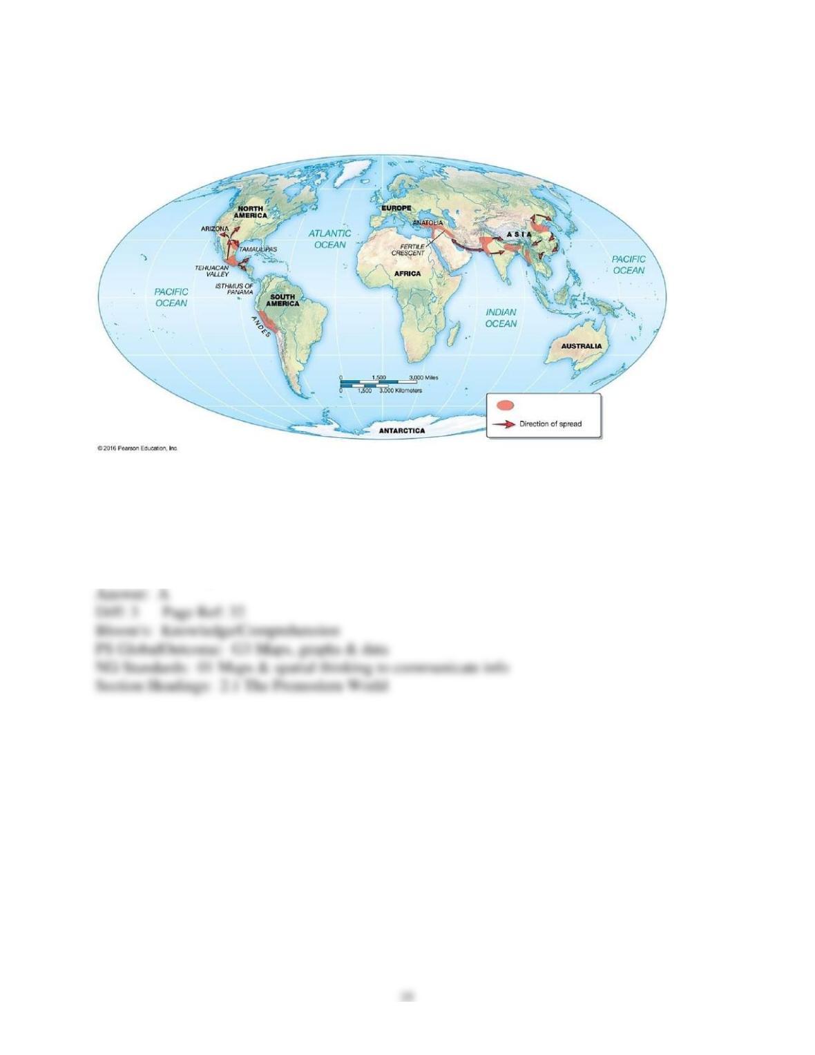
2.3 Questions with Images
1) The regions highlighted in the above map represent
A) Old World Hearth areas.
B) colonies of Roman Empire.
C) New World hearth areas.
D) areas targeted for new Starbucks franchises.
E) centers in the spread of the industrial revolution.
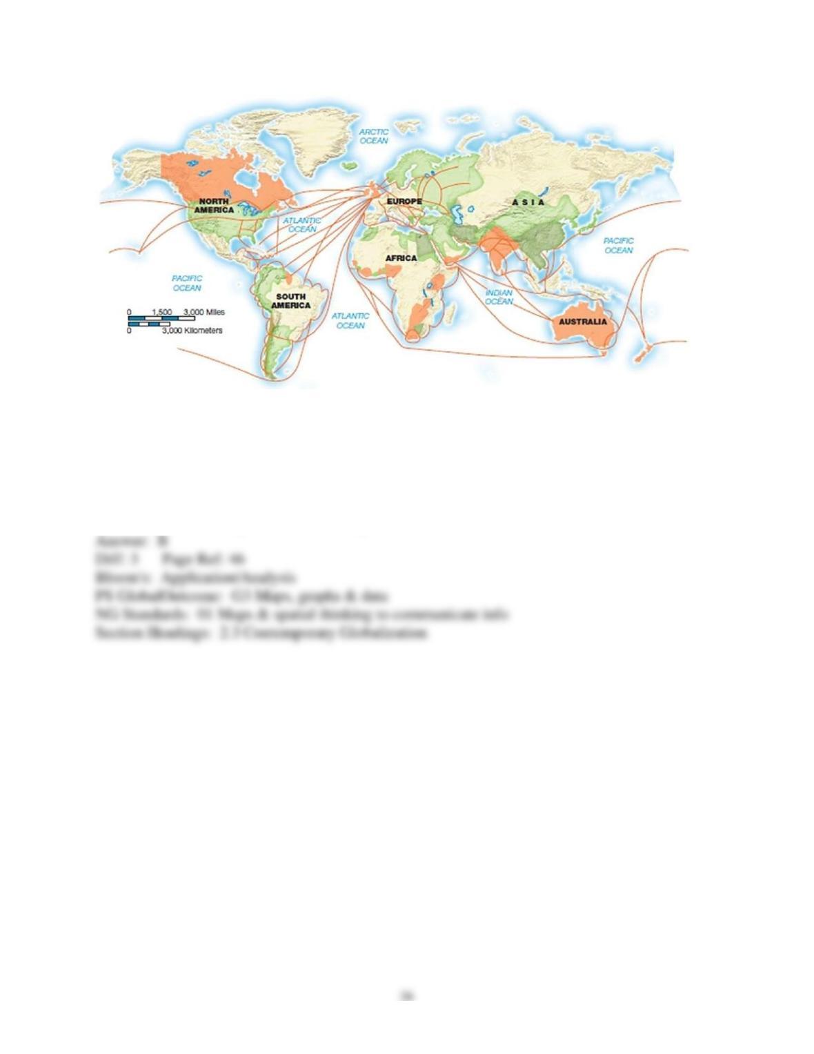
2) The above map shows the
A) international slave trade in the 17th century.
B) British Empire’s web of commerce in the late 18th century.
C) world-wide spread of industrialization in the 19th century.
D) spread of HIV/AIDS in the 20th century.
E) Internet connectivity in the 21st century.
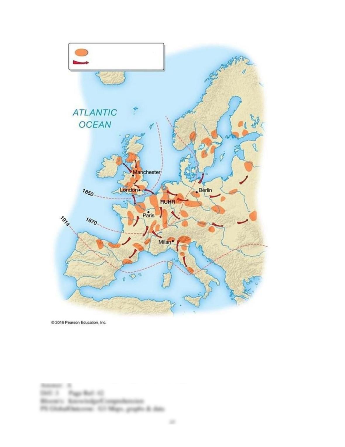
3) The above map represents
A) the spread of the Industrial Revolution across Europe.
B) the expansion of British colonialism.
C) the occurrence of local conflicts that led to World War I.
D) the migration of refugees from England.
E) the diffusion of nuclear power plants across Europe.
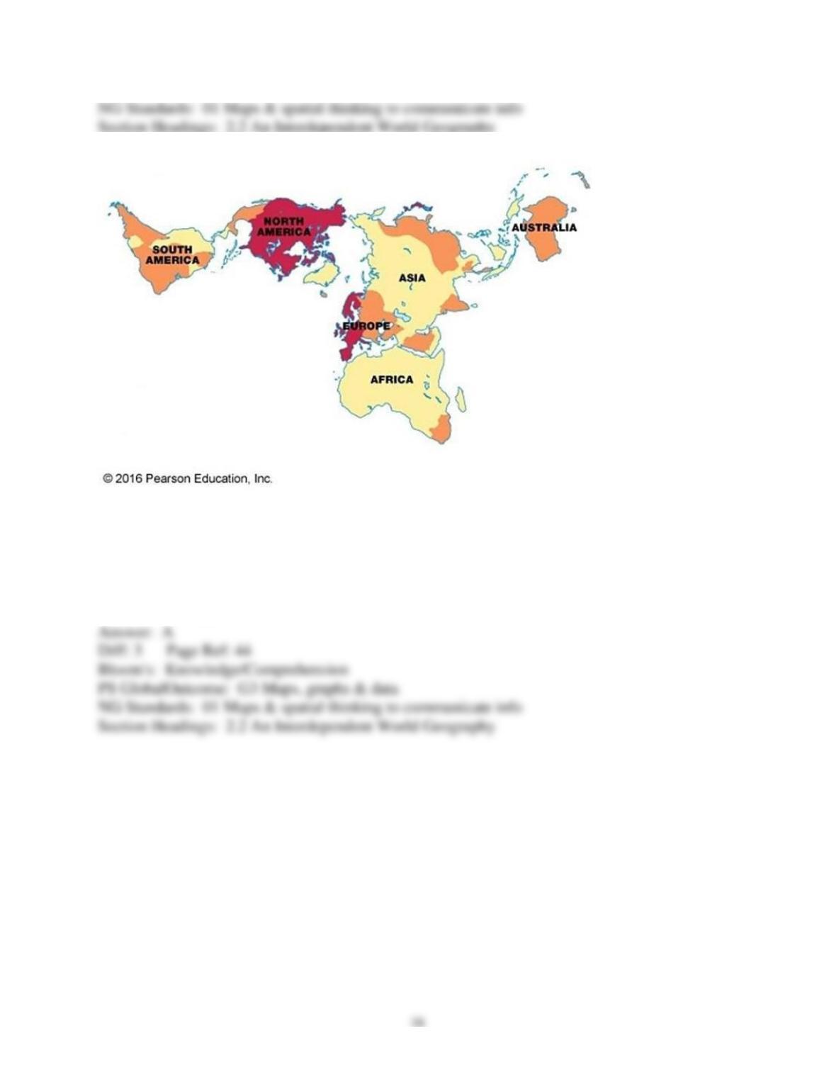
4) In the above map, the darkest shaded regions represent the world’s
A) core.
B) periphery.
C) external arenas.
D) hearth areas.
E) wealthiest colonies.
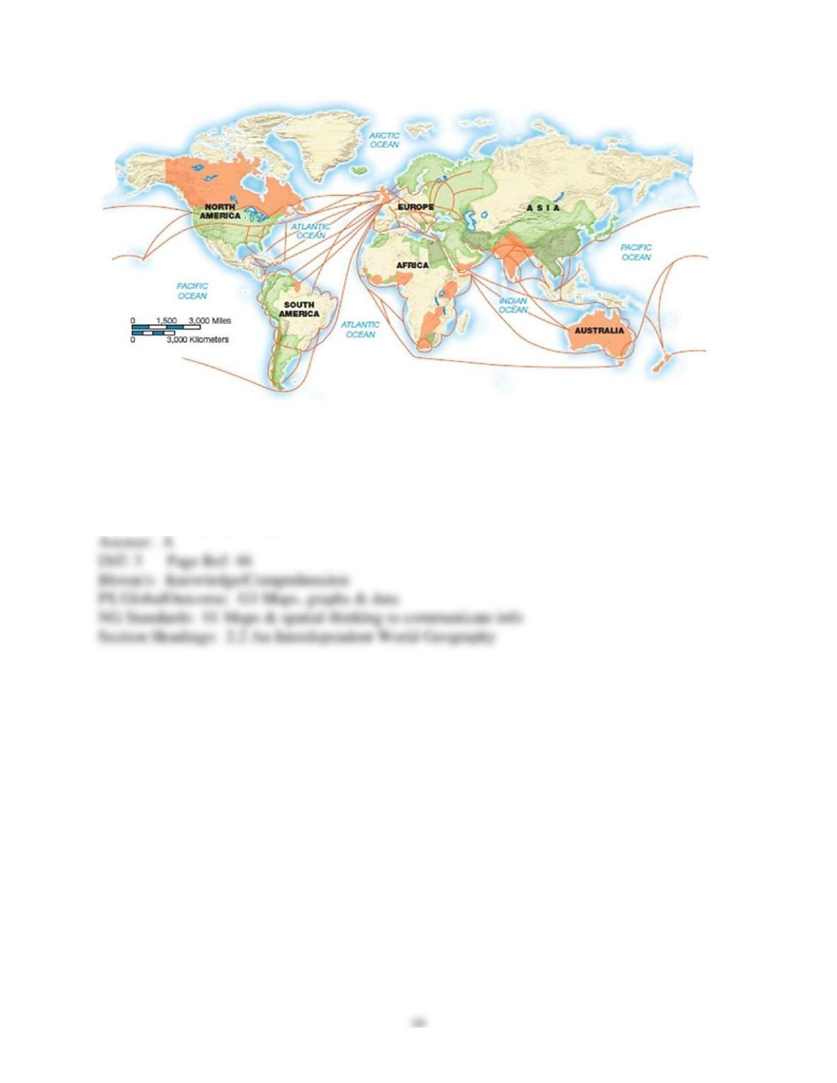
5) The above map best represents
A) colonies and trading patterns of the British Empire.
B) today’s world core.
C) the Silk Road and its trading routes.
D) global Internet connectivity.
E) the Columbian Exchange.