Geosystems: An Introduction to Physical Geography, 9e (Christopherson)
Chapter 17 Glacial and Periglacial Processes and Landforms
17.1 Multiple Choice Questions
1) Approximately, what percentage of the Earth’s freshwater is frozen?
A) 10%
B) 25%
C) 50%
D) 75%
2) The bulk of ice on Earth is in
A) North America, specifically Alaska.
B) European and Asian mountain ranges.
C) Greenland and Antarctica.
D) floating ice shelves and packs.
3) Which of the following is not true?
A) Many western states heavily rely on snowmelt for municipal water supplies.
B) Seasonal snowpacks increases the Earth’s albedo.
C) The cryosphere compromises only a small, but very important component of Earth’s
freshwater resources.
D) Decreases in snow cover may create a positive feedback loop as decreased albedo can lead to
more warming.
4) A snowline refers to
A) the latitude or elevation at which winter snow accumulates each year.
B) the latitude demarcating the extent of glacial ice during the last glacial maximum.
C) an isoline demarcating the extent of snow or ice on a weather map.
D) the lowest line (latitude or elevation) where winter snow accumulation persists throughout the
summer.
5) Which of the following is correct regarding the snowline?
A) It increases in elevation with increasing latitude.
B) It decreases in elevation with increasing latitude.
C) It occurs at approximately the same elevation at all latitudes because the environmental lapse
rate is approximately the same at all latitudes.
6) Partially compacted snow that is an intermediate between snow and ice is called a(n)
A) firn.
B) glacier.
C) moraine.
D) snowline.
7) Glacial ice is
A) essentially the same as snow.
B) formed from continual accumulation of snow that recrystallizes under its own weight into an
ice mass over a period of many years.
C) made of sedimentary rock.
D) generally less dense than snow and firn.
8) Why is glacial ice analogous to a metamorphic rock?
A) It has a definite chemical composition.
B) It has a crystalline structure.
C) It forms as a result of recrystallization caused by pressure.
D) It is solid.
9) The transformation of snow into glacial ice in Antarctica takes ________ than in midlatitude
alpine glaciers because ________.
A) less time; more snow fall in the polar regions each year slows the glacier formation process
B) less time; there is more melting and refreezing in the midlatitudes and, therefore, it takes
much longer there
C) longer; the long summer days in Antarctica (up to 24-hours) results in more sunlight
impeding the glacier development process
D) longer; the dryness of the Antarctic climate and minimal snowfall as compared to wetter
climates with constant snowfall
10) A general term for a mass of perennial ice, resting on land or floating in the sea attached to a
landmass is
A) the snowline.
B) an iceberg.
C) a glacier.
D) a moraine.
4
11) Which of the following is incorrect about glacial movement?
A) Glaciers move under the pressure of their own weight and the pull of gravity.
B) Glaciers move in streamlike patterns, merging as tributaries into large rivers of ice.
C) Glacial movement produces distinct landforms.
D) Glaciers are mostly stationary, only moving several centimeters over tens of years.
12) Alpine glaciers include all of the following except
A) an ice cap.
B) a piedmont glacier.
C) a cirque glacier.
D) a valley glacier.
13) Which of the following is correct regarding valley glaciers?
A) The snowfield sources for these glaciers are usually found right at the snowline.
B) They occur in an unconfined environment—like an open plain.
C) They may range in length from 100 m (325 ft.) to 100 km (62 mi.).
D) They remain stationary and do not move.
14) Several valley glaciers coalescing at the base of a mountain range form a(n)
A) cirque glacier.
B) ice cap.
C) piedmont glacier.
D) tidewater glacier.
15) A glacier confined in a bowl-shaped recess is known as a(n)
5
A) cirque glacier.
B) valley glacier.
C) piedmont glacier.
D) tidewater glacier.
16) The process of calving produces
A) moraines.
B) nunataks.
C) tidewater glacier.
D) icebergs.
17) An extensive, continuous mass of ice covering a continental scale is known as a(n)
A) tidal glacier.
B) ice sheet.
C) piedmont glacier.
D) tidewater glacier.
18) The type of glacier that dominates Greenland and Antarctica is an
A) ice cap.
B) ice sheet.
C) ice field.
D) ice shelves.
19) The average thickness of the Greenland and Antarctic ice sheets is more than
A) 1,000 m (3,280 ft).
B) 2,000 m (6,500 ft).
C) 3,000 m (9,800 ft).
D) 4,000 m (13,100 ft).
20) In terms of areal extent, which of the following sequences is ordered from largest to smallest
extent covered?
A) ice sheet, ice field, ice cap, alpine glacier
B) ice sheet, ice cap, ice field, alpine glacier
C) alpine glacier, ice field, ice cap, ice sheet
D) ice sheet, alpine glacier, ice field, ice cap
7
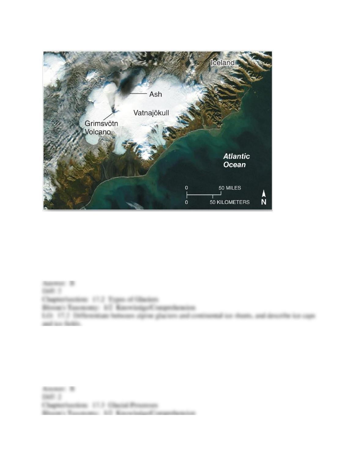
21)
Vatnajökull is the largest and most voluminous Icelandic glacier. It is roughly circular in shape,
overlays several volcanoes, and covers an area of approximately 8,100 km2 (3,100 mi2) with an
average thickness of 400 m (1,300 ft). This is an example of a(n)
A) ice sheet.
B) ice cap.
C) ice field.
D) alpine glacier.
22) The accumulation zone of a glacier ends at the ________, which marks the elevation above
which the winter snow and ice remained intact throughout the summer.
A) ice field
B) firn line
C) snow line
D) terminal moraine
23) The various processes that result in the loss of a glacier’s mass are known collectively as
A) sublimation.
B) deflation.
C) surface melting.
D) ablation.
24) A glacier’s mass balance is determined by
A) accumulation.
B) ablation.
C) both accumulation and ablation.
D) neither accumulation nor ablation.
25) The zone where accumulation balances ablation is known as the
A) equilibrium line.
B) medial moraine.
C) snowline.
D) crevasses.
26) The upper portion of a glacier flows ________ the lower portion of the glacier.
A) faster
B) slower
C) at the same speed.
27) Which of the following is not generally correct regarding the basal layer of a glacier?
A) It can extend tens of meters above the ground surface.
B) It tends to flow more slowly than the overlying parts of the glacier.
C) It contains more debris than other parts of the glacier.
D) Crevasses form in this region of the glacier.
28) Crevasses usually form as a result of
A) regelation.
B) ablation.
C) deposition.
D) friction, tension, and compression.
29) Glacial surges may be associated with
A) water pressure under the glacier.
B) soft bed below the glacier.
C) lubrication from meltwater.
D) water pressure, soft bed, or lubrication.
30) During a glacier surge, a glacier may move at a speed of
A) 1 cm per day.
B) 1 meter per hour.
C) tens of meters per day.
D) a few kilometers per hour.
31) All of the following are related to glacial erosion except
A) ablation.
B) abrasion.
C) plucking.
D) erratics.
32) Glacial polish results from
A) abrasion.
B) ice plucking.
C) regelation.
D) ablation.
33) An asymmetrical hill of exposed bedrock produced by plucking and abrasion is known as
a(n)
A) esker.
B) drumlin.
C) roche moutonnée.
D) bergschrund.
34) ________ are sharp ridges that form when glaciers erode parallel valleys.
A) Arêtes
B) Eskers
C) Drumlins
D) Bergschrunds
35) When several cirque glaciers gauge an individual mountain summit from all sides, a
pyramidal peak known as a ________ results.
A) col
B) horn
C) hanging valley
D) arêtes
36) A glaciated valley is ________ shaped; a stream cut valley is ________ shaped.
A) V-; U-
B) U-; V-
C) U-; U-
D) V-; V-
37) Which of the following is now an erosional feature formed by an alpine glacier?
A) cirque
B) horn
C) drumlin
D) col
38) A long, narrow glacially-eroded inlets in which the sea extends inland are known as
A) cirques.
B) fjords.
C) tarns.
D) paternoster.
39) The general term for all glacial deposits is
A) alluvium.
B) erg.
C) glacial drift.
D) talus.
40) Sediments deposited by glacial ice are ________; material deposited by glacial meltwater are
________.
A) sorted; sorted
B) unsorted; unsorted
C) unsorted; sorted
D) sorted; unsorted
41) A class of landforms formed by the accumulation of glacial till are known as
A) drift.
B) alluvium.
C) outwash.
D) moraines.
42) The lengthy ridges of till along each side of an alpine glacier are ________ moraines.
A) ground
B) terminal
C) medial
D) lateral
43) If two glaciers with lengthy ridges of till along each side of the glacier merge, a ________
moraine may form.
A) ground
B) terminal
C) medial
D) lateral
44) Eroded debris dropped at the glacier’s farthest extent is called ________ moraine.
A) ground
B) terminal
C) medial
D) lateral
45) A deposition of till that forms behind a terminal moraine as the glacier retreats and is
generally spread widely across the ground surface is called a(n)
A) outwash plain.
B) till plain.
C) drumlin swarm.
D) lateral moraine.
46) The present of till indicates
A) deposition by water.
B) deposition by a glacier.
C) deposition by wind.
D) deposition of unknown origin (wind, water, or glacial).
14
47) Elongated hills, often in the shape of an inverted spoon, streamlined in the direction of
glacial movement are called
A) eskers.
B) kettles.
C) drumlins.
D) horns.
48) Sorted sediment deposited by glaciofluvial action are called
A) glacial erratics.
B) stratified drift.
C) till.
D) moraines.
49) The area of sediment deposit by by glaciofluvial action beyond the glacial terminus is known
as the
A) till plain.
B) terminal moraine.
C) outwash plain.
D) end moraine.
50) A long, narrow, sinuous ridge of stratified sand and gravel located in a till plain is known as
a(n)
A) drumlin.
B) kame.
C) esker.
D) kettle.
51) A small hill, knob, or mound of glaciofluvial sorted sand and gravel that forms on the surface
15
of a glacier and is later left on the left surface after the glacier retreats is a(n)
A) drumlin.
B) kame.
C) esker.
D) kettle.
52) a steep-sided glaciofluvial landform that occur as the result of blocks of ice calving from the
retreating glacier and subsequent accumulation of till around the melting ice block is known as
a(n)
A) drumlin.
B) kame.
C) esker.
D) kettle.
53) The term periglacial refers to
A) areas that are on top of a glacier.
B) regions that are too warm for ground ice.
C) cold climate processes along the margins of glaciers.
D) process and effects that existed during the last ice age.
54) Which of the following statements is incorrect?
A) Periglacial regions occupy about 30% of the Earth’s land surface.
B) Periglacial environments occur at high latitudes and high elevations.
C) There are no permafrosts regions in Alaska due to its maritime subarctic climate.
D) Permafrost develops in areas where soil, sediment, or rock temperatures remain below 0°C
(32°F) for at least two years.
55) Periglacial environments are likely to occur in which of the following climate types?
A) tundra
B) mesothermal
C) humid continental
D) desert
56) Which of the following is correct regarding permafrost?
A) It develops where soil or rock temperatures are below freezing for at least two years.
B) It primarily occurs in areas covered with glaciers.
C) The surface layer of permafrost never thaws, even in the warm season.
D) It tends to occur at lower elevations in the midlatitudes than in the high latitudes.
57) The zone of seasonally frozen ground that exists between the subsurface permafrost layer
and the ground surface is called the
A) gelifluction.
B) discontinuous region.
C) active layer.
D) talik.
58) Unfrozen ground in a region of discontinuous permafrost is known as
A) nunatak.
B) talik.
C) cryotic zone.
D) patterned ground.
59) Frozen subsurface water in regions of permafrost is called
A) talik.
B) the active layer.
C) ground ice.
D) periglacial water.
60) Vertical and horizontal movement caused by the expansion of freezing water are called
A) frost heaving and frost thrusting, respectively.
B) frost thrusting and frost heaving, respectively.
C) frost heaving.
D) frost thrusting.
61) The expansion and contraction of frost action results in the movement of soil particles,
stones, and small boulders into distinct shapes know as
A) gelifluction.
B) patterned ground.
C) taliks.
D) solifluction.
62) Solifluction is most similar to which mass movement process?
A) slump
B) mudflow
C) creep
D) fall
63) Which of the following is not an adaptation to living in periglacial regions?
A) buildings placed directly on frozen, hard surfaces
B) enclosed water and sewage lines
C) raised oil pipelines above the frozen ground
D) careful maintenance of rail tracks and roadbeds in the summer
64) Which of the following is not correct regarding the Pleistocene?
A) Sea levels were 100 m (330 ft.) higher than today.
B) At its height almost a third of Earth was covered with ice.
C) It began 1.65 mya and had at least 18 glacial/interglacial cycles.
D) The Ohio and Missouri River systems marked the southern terminus of continuous ice at its
greatest extent.
65) Which of the following is incorrect relative to the PLeistocene Epoch?
A) It began 1.65 million years ago.
B) In some areas the ice sheets were more than 2 km (1.2 mi) thick.
C) The ice sheets disappeared approximately 7,000 years ago.
D) It represents a single, continuous cold spell.
66) The Great Lakes of North America were created by
A) ice sheets that enlarged and deepened stream valleys to form the basins of the future lakes.
B) the deposition of ice in till plains.
C) cirque glaciers.
D) isostatic subsidence of the crust.
67) Sea levels 18,000 years ago were approximately
A) 100 m (330 ft) lower than they are today.
B) 50 m (165 ft) higher than they are today.
C) 10 m (33 ft) higher than they are today.
D) 25 m (82 ft) lower than they are today.
68) Which of the following is not an example of a pluvial lake?
A) Lake Superior
B) Lake Bonneville
C) Lake Lahontan
D) Lake Russell
69) During the Pleistocene pluvial lakes formed in the ________ United States as a result of
________.
A) southwestern; melting glaciers
B) southwestern; extended periods of wet conditions
C) northeastern; ice deposits in till plains
D) northeastern; melting glaciers
70) The Great Salt Lake is a remnant of which pluvial lake?
A) Lake Russell
B) Lake Bonneville
C) Lake Lahontan
D) Lake Manix