Exam
Name___________________________________
MULTIPLE CHOICE. Choose the one alternative that best completes the statement or answers the question.
1)
The hot spring deposits at Mammoth Hot Springs, Yellowstone National Park, are travertine. What
rock probably lies somewhere beneath the hot springs?
1)
A)
limestone
B)
shale
C)
rhyolite
D)
quartzite
2)
The term karst topography was first used in ________.
2)
A)
the Republic of Slovenia, a province of the former Yugoslavia
B)
eastern Canada in areas of fractured igneous and metamorphic rocks
C)
Australia for the extremely dry interior area near Ayres Rock and Alice Springs
D)
India near the southern foothills of the Himalayan Mountains
3)
Excessive groundwater withdrawals can cause ________.
3)
A)
an influent stream becomes an effluent stream
B)
the water table drops or declines in elevation
C)
expansion of the dewatered aquifer
D)
porosity in the aquifer increases as the water is removed
4)
Which one of the following statements is TRUE for an artesian aquifer?
4)
A)
Upward flow from a permeable aquitard is prevented by a confining aquifer.
B)
In deep, stream–cut valleys, many springs are fed from artesian aquifers.
C)
The water table in the recharge area is at a higher elevation than the top of the aquifer in the
subsurface.
D)
The pressure at any point in the aquifer is considerably less than the weight of the water
column between the point and the top of the aquifer.
5)
What force pushes groundwater from pore to pore below the water table?
5)
A)
seepage affluence actor
B)
integrated saturation impulse
C)
pressure gradient or hydraulic gradient
D)
permeability steepness
6)
The unsaturated zone ________.
6)
A)
is a well–oxygenated, shallow aquifer
B)
pore spaces are filled with water
C)
lies below the capillary fringe zone
D)
lies above the water table
7)
Which of the following geologic materials would have the highest groundwater velocities and be
least effective in removing unwanted pollutants from the water?
7)
A)
unconsolidated medium–grained sand; sand grains are coated with clay minerals
B)
limestone; numerous solution channels and fractures widened by dissolution
C)
lakebeds; unconsolidated very fine–grained sand and silt
D)
sandstone; well–cemented with a few, widely spaced vertical fractures
8)
For unconfined aquifers, what hydrologic factor is approximated by the slope of the water table?
8)
A)
affluent decline
B)
hydraulic gradient
C)
porosity head
D)
hydro competency
9)
Which of the following can logically be concluded by speleothems/dripstone hanging from a cave
roof?
9)
A)
The cave roof was above the water table when the speleothems formed.
B)
The cave floor was above the water table and the roof was below the water table when the
speleothems formed.
C)
The cave roof was below the water table when the speleothems formed.
D)
The cave roof was below the water table sometime after the speleothems had formed.
10)
________ are characteristics found in all good aquifers.
10)
A)
Low porosity and low permeability
B)
Low permeability and high potability
C)
High potability and high portability
D)
High porosity and high permeability
11)
What is the relationship between drawdown and the cone of depression associated with a pumping
well?
11)
A)
There is no relationship between drawdown and the cone of depression.
B)
The drawdown is the percentage of available water in the aquifer that has already been used.
C)
The drawdown is the diameter of the cone of depression measured at the elevation of the
original water table.
D)
Drawdown is the distance between the original water table and the water level in the well.
12)
Which one of the following concerning artesian wells is NOT true?
12)
A)
When the well penetrates the aquifer, the water rises to the bottom of the aquitard above the
aquifer.
B)
The well penetrates an aquifer overlain by an aquitard.
C)
The well penetrates an aquifer underlain by an impermeable bed.
D)
The aquifer is generally inclined, and it is saturated to an elevation above the point where the
well penetrates the aquifer.
13)
After ice sheets and glaciers, ________ contain(s) the next highest percentage of Earth’s freshwater.
13)
A)
lakes and rivers
B)
groundwater
C)
rocks and minerals
D)
the atmosphere
14)
Where are the most extensive geothermal features in the world?
14)
A)
Iceland’s Groundwater Preserve
B)
Yosemite National Park, United States
C)
Geysers Artesian Park, Japan
D)
Yellowstone National Park, United States
15)
An artesian well is one in which ________.
15)
A)
pressurized groundwater rises from a deep, unsaturated aquifer
B)
the well is horizontal and the water table is perched
C)
the water is warm, fairly saline, and recharged by an affluent stream
D)
water rises above the top of the aquifer without any pumping
D
16)
The water table is ________.
16)
A)
a boundary between saturated rock below and unsaturated rock above
B)
an underground mass of partly saturated rock
C)
a boundary between unsaturated bedrock below and saturated bedrock above
D)
a boundary between unsaturated bedrock and an underground river
A
17)
An aquifer is ________.
17)
A)
a saturated, porous, and permeable layer or stratum
B)
an unsaturated, influent–flow bed or stratum below a spring
C)
the porous and permeable, saturated cone of depression in an aquitard
D)
a layer or stratum in which groundwater flows downward to the water table
A
D
18)
Which one of the following concerning stalactites and stalagmites is NOT true?
18)
A)
Both are composed of calcium carbonate.
B)
Both are forms of dripstone; stalactites hang from the ceiling, stalagmites grow upward from
the cavern floor.
C)
Stalagmites form on the floors of caves below the water table.
D)
Stalactites are deposited from water dripping from the ceiling of an aerated cavern.
19)
________ account(s) for the largest usage of groundwater in the United States.
19)
A)
Agriculture and irrigation
B)
Domestic and municipal supplies
C)
Industrial uses
D)
Water for livestock and poultry
A
20)
________ are specific features of karst topography.
20)
A)
Numerous artesian wells in a given area
B)
Perched water table springs on hillsides
C)
Perennial, influent streams fed by large springs
D)
Streams flowing into depressions and continuing underground
D
21)
A ________ is the icicle–like speleothem that grows down from the roof of a cavern.
21)
A)
stalactite
B)
stalagmite
C)
slagdite
D)
stalandite
A
22)
Which common, rock–forming mineral or mineral group is most readily dissolved by
groundwater?
22)
A)
calcite
B)
quartz
C)
clay minerals
D)
feldspars
A
C
23)
An unconfined water table is the ________.
23)
A)
boundary between the saturated zone above and partly saturated zone below
B)
boundary between the aerated zone above and saturated zone below
C)
bottom boundary surface of the saturated zone above an aquitard
D)
boundary between the aerated and unsaturated zones
24)
________ would have the largest capacity to naturally remove sewage pollutants.
24)
A)
Slightly clayey sand
B)
Well–sorted, coarse gravel
C)
Fractured granite
D)
Limestone with solution channels and caverns
25)
Which of the following statements is TRUE concerning unconfined aquifers in urbanized coastal
areas?
25)
A)
Pumping freshwater from one, large capacity well is much less likely to cause salty water to
rise in the aquifer than pumping from several, widely spaced, smaller capacity wells.
B)
Wells drilled below sea level will produce only saline water.
C)
Any salty water in the aquifer will rise if the water table is lowered by pumping.
D)
The water table must be 40 feet above sea level to keep the salty water in the aquifer below
sea level.
26)
Which of the following best describes how geysers erupt?
26)
A)
Water suddenly boils in disconnected voids and cracks above the water table, causing the
aquifer to explosively fragment.
B)
Water slowly boils in a network of vertical cracks above the water table, sending up a plume
of steam and hot water.
C)
With a slight reduction in pressure, water in a saturated, natural conduit suddenly boils,
sending a plume of steam and hot water into the air above the vent.
D)
Water below the water table slowly boils in a vertical crack or natural conduit, causing a
plume of condensed water vapor to rise above the vent.
27)
________ is the volume of voids or open space in a rock or unconsolidated material.
27)
A)
Saturation index
B)
Porosity
C)
Space yield
D)
Permeability
28)
Which one of the following is not a speleothem?
28)
A)
stalactite
B)
geyserite
C)
dripstone
D)
stalagmite
29)
A stream is said to be a losing stream when ________.
29)
A)
the channel bottom is above the local water table
B)
the local water table is above the channel bottom
30)
________ controls the ease (or difficulty) of groundwater transmission through a porous material.
30)
A)
Portability
B)
Permeability
C)
Potability
D)
Permeosity
31)
A disappearing (sinking) creek is ________.
31)
A)
a creek that originates as a large spring flowing from a cave
B)
an influent stream in a karst area
C)
a stream that downcuts below the water table
D)
a small creek flowing downslope to the top of a perched water table
32)
A perched water table develops when ________.
32)
A)
an aquifer below the regional water table is underlain by a horizontal aquitard
B)
a horizontal aquitard above the regional water table lies below an aquifer
C)
an aquifer above the regional water table is overlain by a horizontal aquitard
D)
an aquitard below the regional water table lies above a horizontal aquifer
SHORT ANSWER. Write the word or phrase that best completes each statement or answers the question.
33)
What feature originates where the water table intersects the land surface?
33)
34)
Dripstone and travertine are composed of ________.
34)
35)
Which speleothem grows upward from the floor of a cavern?
35)
36)
A(n) ________ is a circular to elliptical, closed depressions in karst areas.
36)
37)
A terrain exhibiting many distinctive features related to subsurface solution of limestone is
known as ________.
37)
Word Analysis. Examine the words and/or phrases for each question below and determine the relationship among the
majority of words/phrases. Choose the option that does not fit the pattern.
38)
a. porosity b. permeability c. aquitard d. aquifer
38)
39)
What term describes a stream from which water is infiltrating downward to the water
table?
39)
40)
What property describes how readily groundwater will flow through a saturated porous
material?
40)
Word Analysis. Examine the words and/or phrases for each question below and determine the relationship among the
majority of words/phrases. Choose the option that does not fit the pattern.
41)
a. zone of saturation b. zone of soil moisture c. capillary fringe d. unsaturated
zone
41)
42)
What term denotes the percentage of open space or voids in a material?
42)
43)
Which term denotes the physical force that pushes water though a saturated porous
material?
43)
44)
Highly impermeable layers such as compacted clay or shale are known as ________.
44)
45)
The ________ is the upper boundary surface of the saturated zone.
45)
46)
A stream flowing into a sinkhole is called a(n) ________.
46)
47)
A hydrothermal vent that periodically or occasionally erupts a column of steam and hot
water is called a(n) ________.
47)
Word Analysis. Examine the words and/or phrases for each question below and determine the relationship among the
majority of words/phrases. Choose the option that does not fit the pattern.
48)
a. stalagmite b. soda straw c. sinkhole d. stalactite
48)
49)
Which slender, conical speleothem grows from water dripping from the ceiling of a
cavern?
49)
50)
What hydrogeological condition describes a local zone of saturated soil or rock above the
elevation of the regional water table?
50)
51)
What term describes a groundwater system in which water in a well rises above the top of
the aquifer without use of a pump?
51)
52)
In three words, describe the shape of the water table around a pumping well.
52)
TRUE/FALSE. Write ‘T’ if the statement is true and ‘F’ if the statement is false.
53)
Permeability is the physical force that pushes water below the water table through a porous, rock
material.
53)
54)
A geyser can erupt because the boiling temperature of water decreases with depth below the water
table.
54)
55)
A perched water table develops in hilly terrain where an aquitard underlies an aquifer and both are
above the elevation of the main water table.
55)
56)
In general, contaminated groundwater will be naturally cleaned faster by circulation through
porous and permeable sands than by circulation through fractured, crystalline igneous and
metamorphic rocks.
56)
57)
In areas of karst topography, rare surface streams typically flow into sinkholes and continue
flowing underground for some distance.
57)
58)
The water table separates the saturated and unsaturated zones.
58)
59)
Yosemite National Park in California is world famous for its hot springs, geysers, and other
geothermal phenomena.
59)
60)
Water–saturated muds have low permeabilities but can have greater porosities than
well–cemented sandstone.
60)
61)
Most caves and caverns originate by solution of limestone.
61)
62)
Artesian groundwater conditions can develop in an inclined aquifer with aquitards above and
below.
62)
63)
Lowering of the water table around a pumping well results in a cone of infiltration.
63)
64)
Porosity is a measure of the volume of open space in rocks and unconsolidated, geological
materials like alluvium and soils.
64)
65)
Warm springs in the eastern United States are mainly heated by geologically young, igneous rocks
below the surface.
65)
66)
In areas underlain by unconsolidated or weakly consolidated strata, lowering of the water table can
cause the land to subside.
66)
67)
Speleothems generally form below the water table by water dripping from the roofs of caverns.
67)
68)
Water infiltrates down to the water table from losing streams.
68)
ESSAY. Write your answer in the space provided or on a separate sheet of paper.
Critical thinking and discussion questions. Use complete sentences, correct spelling, and the information presented in
chapter 14 to answer the questions below.
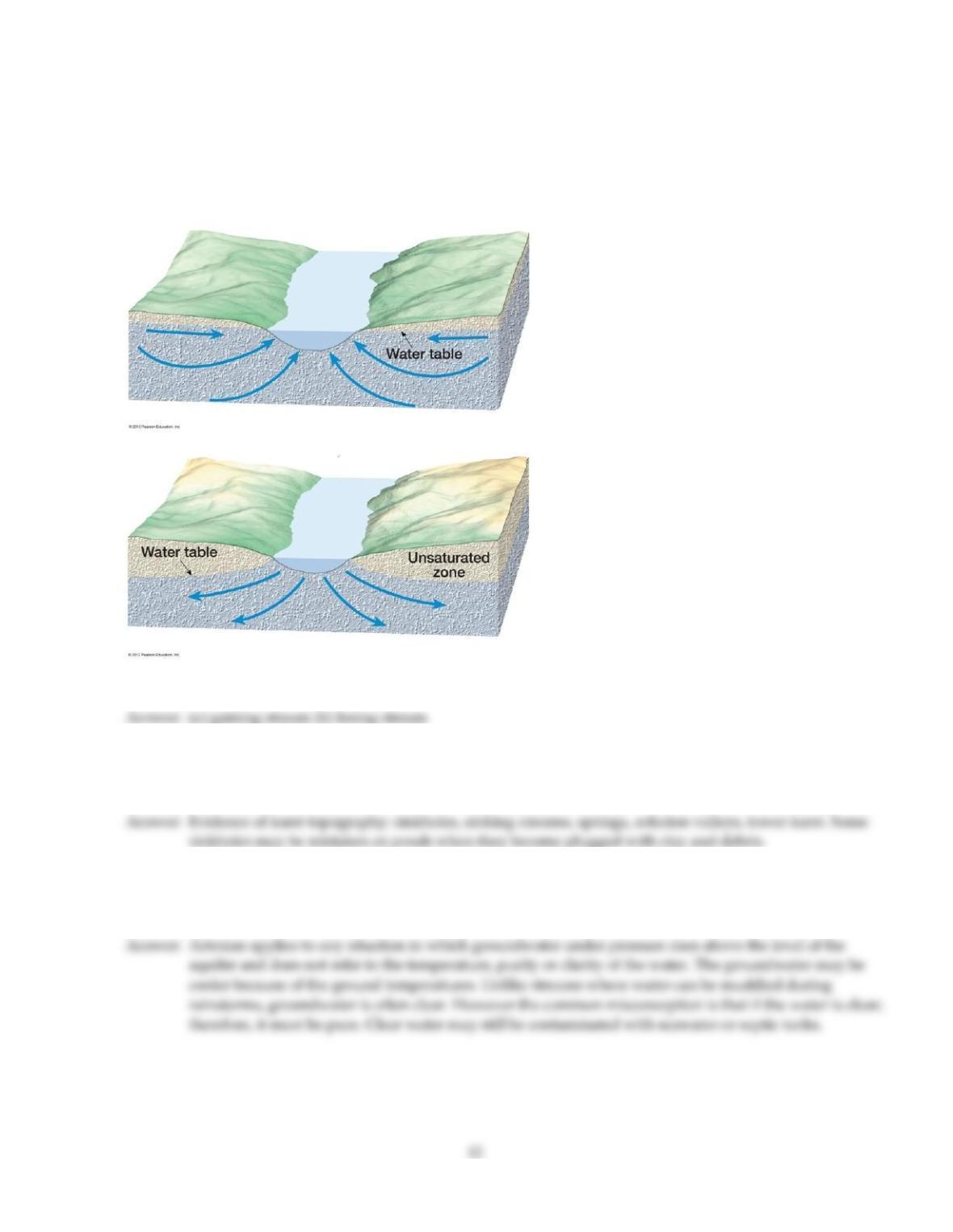
69)
On the blanks provided beside each cross section below, describe what type of stream is represented. Arrows
indicate direction of groundwater flow.
(a) ________
(b) ________
70)
How would you recognize areas of karst topography on a topographic map without knowing the local bedrock
geology? Also, what features of karst topography on a topographic map might be misinterpreted as some other
geologic feature?
71)
“The drinking water in our town is always cold, clear, and pure because it comes from an artesian well.” Briefly
discuss the geologic validity of this statement. Although this idea wasn’t specifically discussed in chapter 14,
give a possible reason or two as to why such statements are often made.
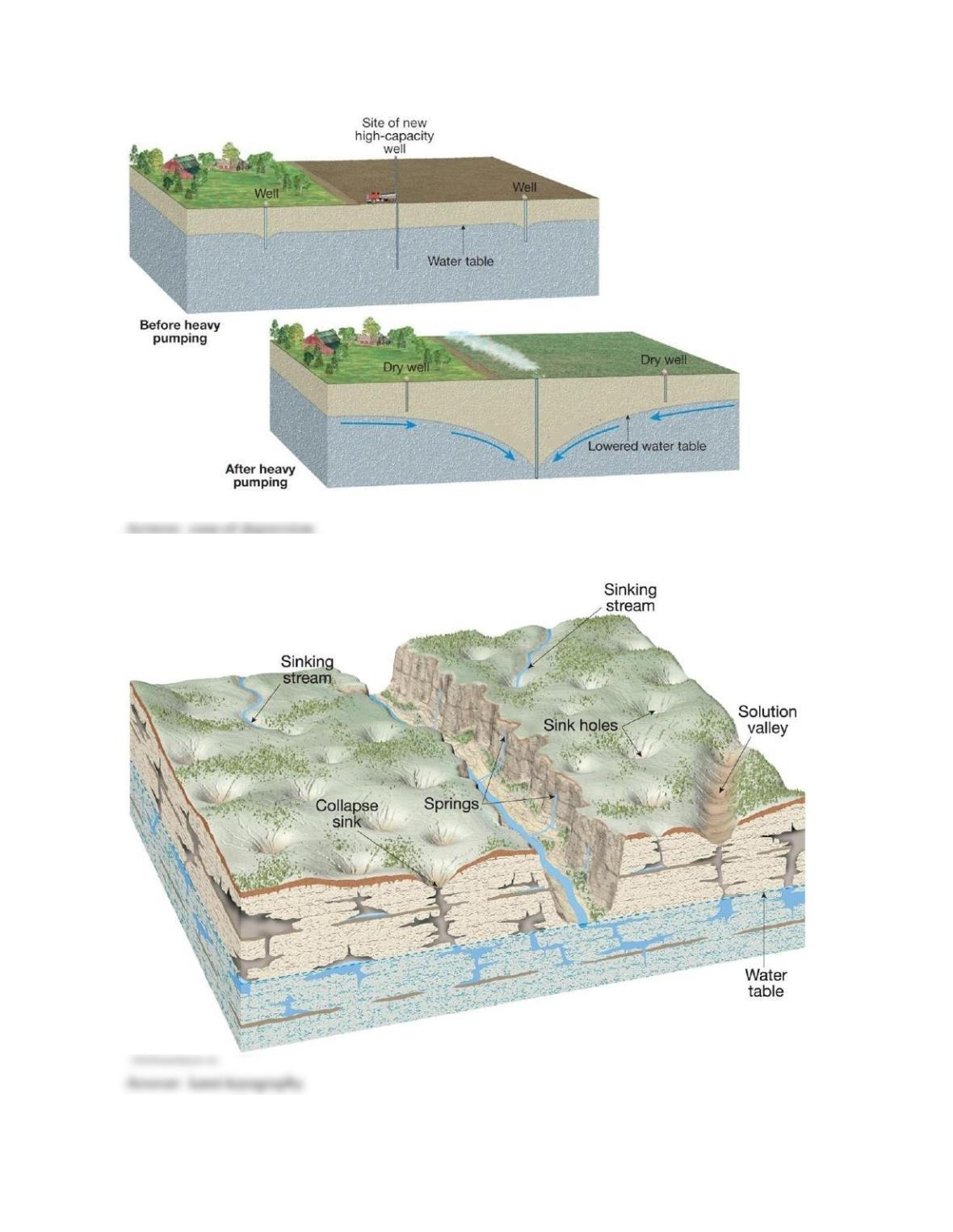
72)
What is the name of the localized lowering of the water table shown in the diagram below?
73)
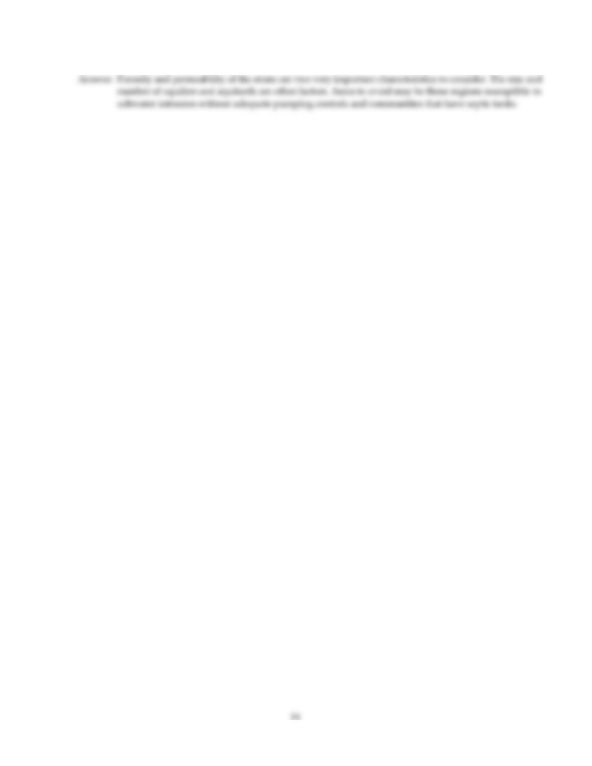
What type of topography is illustrated in the diagram below?
13
74)
When examining the geology of a region for potential aquifers, what characteristics or factors would you
consider? Also, what areas (based on natural and human) factors would you avoid?
Answer Key
Testname: C14
Answer Key
Testname: C14
16