
Exam
Name___________________________________
MULTIPLE CHOICE. Choose the one alternative that best completes the statement or answers the question.
1)
A ________ stream pattern develops on lands underlain by tilted or folded, alternating hard and
soft, sedimentary strata.
1)
A)
boreal
B)
trellis
C)
dendritic
D)
radial
2)
________ generally constitutes the highest percentage of the annual sediment load moved by a
stream.
2)
A)
Dissolved load
B)
Saltation load
C)
Bed load
D)
Suspended load
3)
________ describes the particle transport mode in streams intermediate between suspension and
rolling along the bottom.
3)
A)
Impact leaping
B)
Siltation
C)
Alluviation
D)
Saltation
4)
Many larger rivers in the Colorado Plateau region meander in deep, narrow canyons and have no
floodplains. How could this happen?
4)
A)
Original, youthful streams continued to downcut as the land rose.
B)
Original, old age streams downcut as the land gradually rose.
C)
As sea level rose, the original, old age streams were rejuvenated.
D)
As sea level dropped, the original youthful streams matured into old–age streams.

5)
________ describes the total sediment load transported by a stream.
5)
A)
Discharge
B)
Hydro–load factor
C)
Competence
D)
Capacity
6)
________ in a delta are essentially cross strata inclined toward deeper water.
6)
A)
Topset beds
B)
Bottomset beds
C)
Backset beds
D)
Foreset beds
7)
Which one of the following statements is TRUE concerning natural levees?
7)
A)
They are mostly fine sand and silt that build up during floods.
B)
They are depositional features formed at times of low discharge.
C)
They form the high, steep banks of a downcutting stream.
D)
They are erosional features left behind when meander cutoff occurs.
8)
In the absence of cutoff, how does a river meander loop behave over time?
8)
A)
The gradient is raised as the loop lengthens, and the channel migrates toward the cut or inner
bank of the loop.
B)
The gradient is lowered as the loop shortens, and the channel migrates toward the cut or
inner bank of the loop.
C)
The gradient is lowered as the channel lengthens and migrates toward the cut or outer bank
of the loop.
D)
The gradient is raised as the loop shortens, and the channel migrates away from the cut or
outer bank of the loop.
9)
At the head of a delta, the major channel splits into smaller channels that follow different paths to
the sea. These smaller channels are known as ________.
9)
A)
endotributaries
B)
distributaries
C)
cotributaries
D)
exotributaries

10)
A ________ drainage pattern is common in the Appalachian Valley and Ridge Province.
10)
A)
circular
B)
dendritic
C)
trellis
D)
polygonal
11)
How does urbanization (paving, etc.) affect runoff and infiltration in a small, previously forested,
drainage basin?
11)
A)
both decrease
B)
infiltration decreases; runoff increases
C)
runoff decreases; infiltration increases
D)
both increase
12)
Entrenched meanders are evidence for what sequence of geologic events?
12)
A)
Stream downcutting was followed by a rise in base level.
B)
A sea level rise was followed by stream downcutting.
C)
Lateral cutting by streams was followed by subsidence of the land.
D)
Land uplift was followed by stream downcutting.
13)
A dam and reservoir are constructed on a graded river. What will happen?
13)
A)
deposition upstream and downstream from the dam
B)
channel downcutting upstream and downstream from the dam
C)
deposition upstream from the dam; channel downcutting below
D)
channel downcutting upstream from the dam; deposition below
14)
Which of the following must result in a lower base level for rivers and streams?
14)
A)
Sea level falls; land subsides.
B)
Sea level rises; land subsides.
C)
Sea level falls; land rises.
D)
Sea level rises; land rises.

15)
Which of the following features characterize wide streams and valleys?
15)
A)
rapids; channel bed potholes
B)
V–shaped valley cross–sections
C)
natural levees; broad floodplains
D)
waterfalls; entrenched meanders
16)
A natural, meandering, river channel is modified into a more or less straight and smooth,
canal–like channel. Which of the following statements is correct?
16)
A)
The natural channel had a lower gradient and higher friction than the straight channel.
B)
The straight channel has a higher gradient and more friction than the natural channel.
C)
The natural channel had a lower gradient and less friction than the modified channel.
D)
All of the above statements are true.
A
17)
Which of the following is the correct definition of stream gradient?
17)
A)
the distance traveled by water in a channel times a drop in elevation
B)
the water pressure at the bottom of the stream divided by the stream’s width
C)
the increase in discharge of a stream per unit drop in elevation
D)
the drop in elevation of a stream divided by the distance the water travels
D
18)
A stream begins at an elevation of 200 meters and flows a distance of 400 kilometers to the ocean?
What is the average gradient?
18)
A)
2km/m
B)
0.5 km/in
C)
0.5m/km
D)
2m/km
C
19)
Which one of the following does not apply to stream turbulence and average velocity?
19)
A)
channel shape; bed roughness
B)
stream gradient; channel roughness
C)
discharge; stream gradient
D)
laminar flow; dissolved load
D
C

20)
Why is a bird–foot delta like that of the present–day Mississippi below New Orleans likely to
change naturally toward one with the shape of an equilateral triangle like the upper–case, Greek
letter delta ()?
20)
A)
Increased sediment loads since the mid–nineteenth century have caused the major
distributaries to be filled with sand.
B)
Potential, new, major distributary channels have steeper gradients than existing channels.
C)
Potential, new, distributary channels have higher gradients, causing downcutting of the
existing channels.
D)
Present–day distributaries have higher gradients than potential new ones.
21)
________ is an abandoned, cutoff, meander loop.
21)
A)
A gatorback
B)
A builtrail
C)
A cowhock
D)
An oxbow
D
Explanation:
22)
What is the drop in water surface elevation divided by the distance the water flows?
22)
A)
stream gradient
B)
hydrologic resistance
C)
hydraulic capacity
D)
stream discharge
A
Explanation:
23)
Which one of the following best describes how urbanization affects small–stream watersheds?
23)
A)
Infiltration decreases; lag time between storms and peak runoff is shortened.
B)
Infiltration and lag time between storms and peak runoff increase.
C)
Infiltration is reduced; lag time between storms and peak runoff is increased.
D)
Infiltration increases slightly; lag time between storms and peak runoff decreases.
A
Explanation:
B
Explanation:

24)
________ are components of the hydrologic cycle that release water vapor directly to the
atmosphere.
24)
A)
Precipitation and runoff
B)
Evaporation and transpiration
C)
Discharge and transportation
D)
Runoff and infiltration
25)
Which of the following is the only correct response concerning the location and causes of the
extraordinarily severe, 1993, flooding on the Mississippi River and tributaries?
25)
A)
upper basin; rapid melting of an unusually deep snow pack in early spring
B)
lower basin; very heavy, late summer rains associated with a severe hurricane
C)
lower basin; heavy rains in late spring and early summer
D)
upper basin; very heavy, sustained rainfall in the late spring and early summer
D
26)
A ________ stream pattern is developed only on growing mountains like volcanoes or where the
land surface is tectonically doming upward.
26)
A)
trellis
B)
radial
C)
boreal
D)
dendritic
B
27)
________ is not part of the hydrologic cycle.
27)
A)
Water infiltrating into the soil and bedrock
B)
Calcium carbonate dissolving in soil water and groundwater
C)
Water moving into creeks and streams following a rainstorm
D)
Water evaporating from a lake
B
B

28)
Which one of the following statements correctly describes how stream terraces can form?
28)
A)
Base level rises; the stream downcuts, and the old floodplain is left well above the elevation of
the present–day channel.
B)
A temporary base level is eliminated; the stream aggrades its channel upstream from the old
temporary base level, and the former floodplain is left well above the present elevation of the
stream.
C)
Base level drops; the stream aggrades its channel, and the former floodplain is left below the
present elevation of the stream.
D)
A temporary base level is eliminated; the stream downcuts upstream from the old temporary
base level, and the former floodplain is left well above the present elevation of the stream.
29)
Which one of the following is TRUE concerning a major river system?
29)
A)
Discharge decreases below junctions with perennial tributaries.
B)
Upstream tributaries generally have higher competencies than the major river.
C)
Upstream tributaries generally have lower gradients than the major river.
D)
Channel bed roughness and turbulence generally increase downstream.
30)
Which one of the following statements is correct?
30)
A)
Sea level drops when water is stored in expanding ice sheets and continental glaciers.
B)
Sea level drops when evaporation rates increase over the oceans and when this extra,
atmospheric moisture falls on land as rain.
C)
Sea level rises when water is stored in expanding ice sheets and continental glaciers.
D)
Sea level rises when water is added to the oceans through increased rainfall and increased
inflow from rivers.
31)
________ comprise the suspended loads of most rivers and streams.
31)
A)
Silt and clay–sized, detrital grains
B)
Sand and gravel that move during floods
C)
Dissolved ions and sand
D)
Dissolved salts

32)
________ are characteristics of downcutting streams and a youthful stage of valley evolution.
32)
A)
Meandering channels and natural levees
B)
Wide floodplains
C)
Rapids and lots of whitewater
D)
U–shaped, cross–valley profiles
33)
The ________ River has the largest discharge of any in the world.
33)
A)
Amazon
B)
Congo
C)
Mississippi
D)
Nile
A
34)
The ________ describes the movement of water through Earth’s hydrosphere.
34)
A)
precipitation cycle
B)
aquatic cycle
C)
hydrologic cycle
D)
aqualytic cycle
C
35)
Where is erosion concentrated along a meandering stream?
35)
A)
at the unconsolidated point bars
B)
on the straight channel segments that connect the meander loops
C)
on the outer parts of the meander loops or bends
D)
on the inner banks of the meander loops
C
SHORT ANSWER. Write the word or phrase that best completes each statement or answers the question.
36)
________ is the release of water vapor to the atmosphere by plants.
36)
37)
________ is the total quantity of sediment carried by a river.
37)
38)
________ is the boundary line separating adjacent, stream drainage basins
38)
C

39)
________ is the sediment transport mode in which sand grains alternately bounce up into
the water column, sink, and roll or skip along the bottom before bouncing again.
39)
40)
Which component of the hydrologic cycle describes the recharge of water to the soil and
groundwater systems?
40)
41)
What stream characteristic is measured by the size of the largest particle that a stream can
move?
41)
Word Analysis. Examine the words and/or phrases for each question below and determine the relationship among the
majority of words/phrases. Choose the option that does not fit the pattern.
42)
a. abrasion b. pothole c. cut bank d. natural levee
42)
43)
________ is defined as the drop in elevation of the stream surface divided by the distance
the water flows.
43)
44)
________ refers to sediments deposited from streams.
44)
Alluvium
Word Analysis. Examine the words and/or phrases for each question below and determine the relationship among the
majority of words/phrases. Choose the option that does not fit the pattern.
45)
a. cut bank b. point bar c. oxbow lake d. downcutting
45)
46)
a. gradient b. velocity c. capacity d. discharge
46)
47)
a. natural levees b. rapids c. backswamps d. yazoo
tributaries
47)
48)
________ is the quantity of water flowing past a certain stream cross section per unit time.
48)

49)
The lowest elevation limiting stream erosion is called ________.
49)
Word Analysis. Examine the words and/or phrases for each question below and determine the relationship among the
majority of words/phrases. Choose the option that does not fit the pattern.
50)
a. artificial levees b. dams c. floodplains d.
channelization
50)
TRUE/FALSE. Write ‘T’ if the statement is true and ‘F’ if the statement is false.
51)
Stream discharge is defined as the quantity of water flowing past a specific channel location per
unit time.
51)
52)
The lowest base level for most streams is sea level.
52)
53)
Rapids and waterfalls are characteristic of laterally cutting streams.
53)
54)
Point bars are depositional features located along the outer portions of meander bends.
54)
55)
The lowermost distal portion of the modern Mississippi Delta is a typical bird–foot delta.
55)
56)
Gradients usually decrease downstream in a major river system.
56)
57)
The lower Mississippi River has the largest discharge of any river in North America.
57)
58)
Alluvial fans develop at unusual locations where stream gradients abruptly increase for a short
distance.
58)

59)
Alluvium refers to stream deposits, mainly sand and gravel.
59)
60)
Evapotranspiration and average velocity are both important components of the hydrologic cycle.
60)
61)
Most precipitation in land areas originates by transpiration and by evaporation from lakes and
rivers.
61)
62)
A stream flowing out from a lake cannot downcut below the water surface elevation of the lake.
62)
63)
Urbanization lowers peak discharges on small streams by routing the runoff directly to the stream.
63)
64)
Foreset beds are part of a deltaic, depositional sequence.
64)
65)
Lateral cutting and deposition are important factors in floodplain development.
65)
66)
For the same discharge, gradient, and channel cross–section, a stream with a boulder–strewn bed
would be more turbulent than one with a sandy bed.
66)
67)
After a meander is cut off, the gradient through the newly formed cutoff is steeper than the
gradient along the abandoned meander loop.
67)
68)
A V–shaped valley and no floodplain indicate a youthful, downcutting stream.
68)
69)
Natural levees are constructed of machine–compacted sand and mud; artificial levees are made of
concrete.
69)
ESSAY. Write your answer in the space provided or on a separate sheet of paper.
Critical thinking and discussion questions. Use complete sentences, correct spelling, and the information presented in
chapter 13 to answer the questions below.
70)
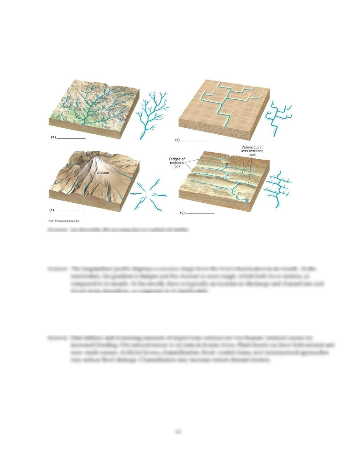
On the blanks provided beside each illustration, name the type of drainage pattern that is illustrated.
71)
Briefly compare those stream characteristics that decrease in a downstream direction with those that increase
downstream. Also, indicate whether or not these changing stream characteristics tend to favor erosion or
deposition of sediments.
72)
A city located on a large river has a history of moderate flooding over its 150–year history. However, the
severity and magnitude of flooding has increased dramatically in the past 30 years. Give some possible reasons,
both natural and human–induced, as to why such increased flooding might occur. What flood control
techniques may be used to reduce flood damage, and how may they contribute to other problems?
73)
What generalizations can you make regarding the geology of a given area by examining stream drainage
patterns on a topographic map? Give some examples. Also, are there limitations to such generalizations?
74)
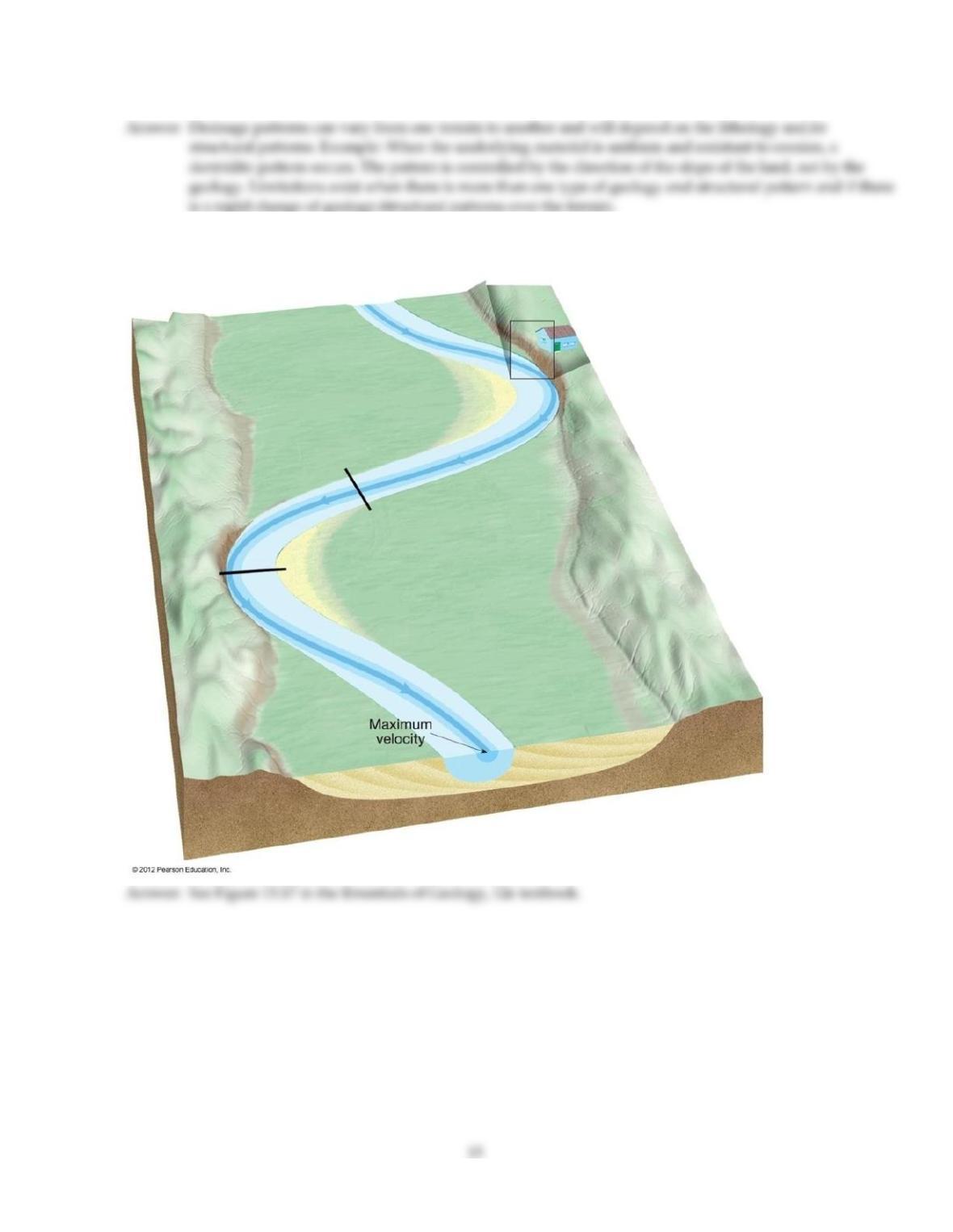
Label a cut bank and the point bar on the diagram below.

Answer Key
Testname: C13
14

Answer Key
Testname: C13