Unlock document.
This document is partially blurred.
Unlock all pages and 1 million more documents.
Get Access
Geosystems: An Introduction to Physical Geography, 9e (Christopherson)
Chapter 13 Tectonics, Earthquakes, and Volcanism
13.1 Multiple Choice Questions
1) Vertical elevation differences in a local landscape are referred to as
A) relief.
B) an order of relief.
C) topography.
D) crust.
2) The general term for the undulations and other variations in the shape of the Earth's surface is
called
A) topography.
B) relief.
C) geomorphology.
D) terrain.
3) Which of the following is an example of the tools scientists use to study topography?
A) LiDAR
B) radar
C) GPS
D) LiDAR, radar, and GPS are all used in the study of topography.
4) ________ provides the highest resolution for mapping Earth's surface.
A) LiDAR
B) Radar
C) GPS
D) Passive remote sensing platforms, such as Landsat 8,
5) The concept of "orders of relief" refers to
A) the ordering of surface features based on height.
B) the ordering of surface features based on their time of origin.
C) the classification of landscapes based on scale.
D) the rate at which stress is relieved in the crust.
6) Which of the following is an example of a first order of relief?
A) the Alps and Rockies
B) the Tibetan Plateau
C) the Shenandoah Valley
D) North America plate
7) Which of the following is an example of a second order of relief?
A) the North American plate
B) Pike's Peak
C) the Canadian and American Rockies
D) Mt. Capulin
8) The most detailed order of relief applies to ________ order relief features.
A) first
B) second
C) third
9) Which of the following is an example of a third order of relief?
A) the Alps
B) the South American Plate
C) Irazú Volcano
D) the Tibetan Plateau
10) Approximately what percentage of Earth's surface is exposed above sea level?
A) 18 percent
B) 29 percent
C) 49 percent
D) 62 percent
11) The measurement of land elevation relative to sea level is known as
A) bathymetry.
B) hypsometry.
C) topography.
D) geodesy.

12)
The average elevation of ocean depth is
A) -2070 m (-6790 ft.).
B) -3800 m (-12,470 ft.).
C) 100 m (325 ft.).
D) 875 m (2870 ft.).
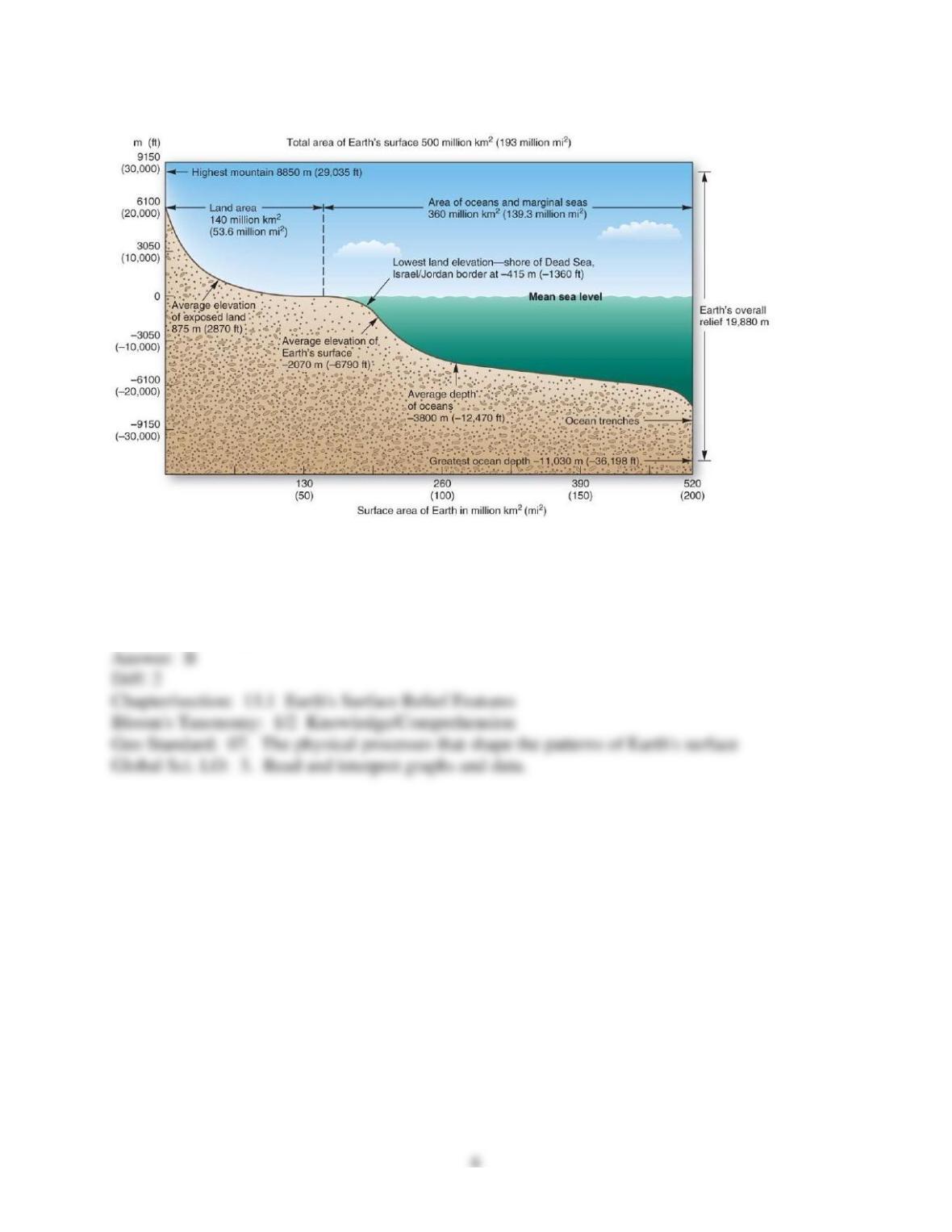
13)
The average elevation of the exposed land is
A) -3800 m (-12,470 ft.).
B) 875 m (2870 ft.).
C) -2070 m (-6790 ft.).
D) 100 m (325 ft.).
14)
The vertical relief of the Earth (highest point to lowest point) is approximately
A) 5 km (3.1 mi).
B) 10 km (6.2 mi).
C) 20 km (12.4 mi).
D) 30 km (18.6 mi).
15) A hypsographic curve is
A) a graph that shows the change in temperature with depth below the surface of a continent.
B) a graph that shows the change in temperature with depth below the surface of the ocean floor.
C) a generalized curve showing Earth's surface by area and elevation in relation to sea level.
D) a graph that shows Earth is of relatively high relief.
E) a graph that shows Earth's relief is great when compared to its diameter.
16) The six types of topographic regions are defined based on
A) arbitrary elevation other descriptive criteria in common use.
B) complex statistical analyses of surface relief variation across the surface of Earth.
C) local criteria that have never been universally recognized.
D) logarithmic relationships applied to elevation.
17) A topographic region that is characterized by local relief of more than 100 m (325 ft.), but
less than 600 m (2000 ft.), is considered a
A) plain.
B) high tableland.
C) hill or low tableland.
D) mountain.
18) A topographic region that is characterized by local relief of less than 100 m (325 ft.) is
considered a
A) plain.
B) high tableland.
C) hill or low tableland.
D) depression.
19) A topographic region that is characterized by local relief of more than 600 m (2,000 ft) is a
A) low tableland.
B) high tableland.
C) mountain.
D) depression.
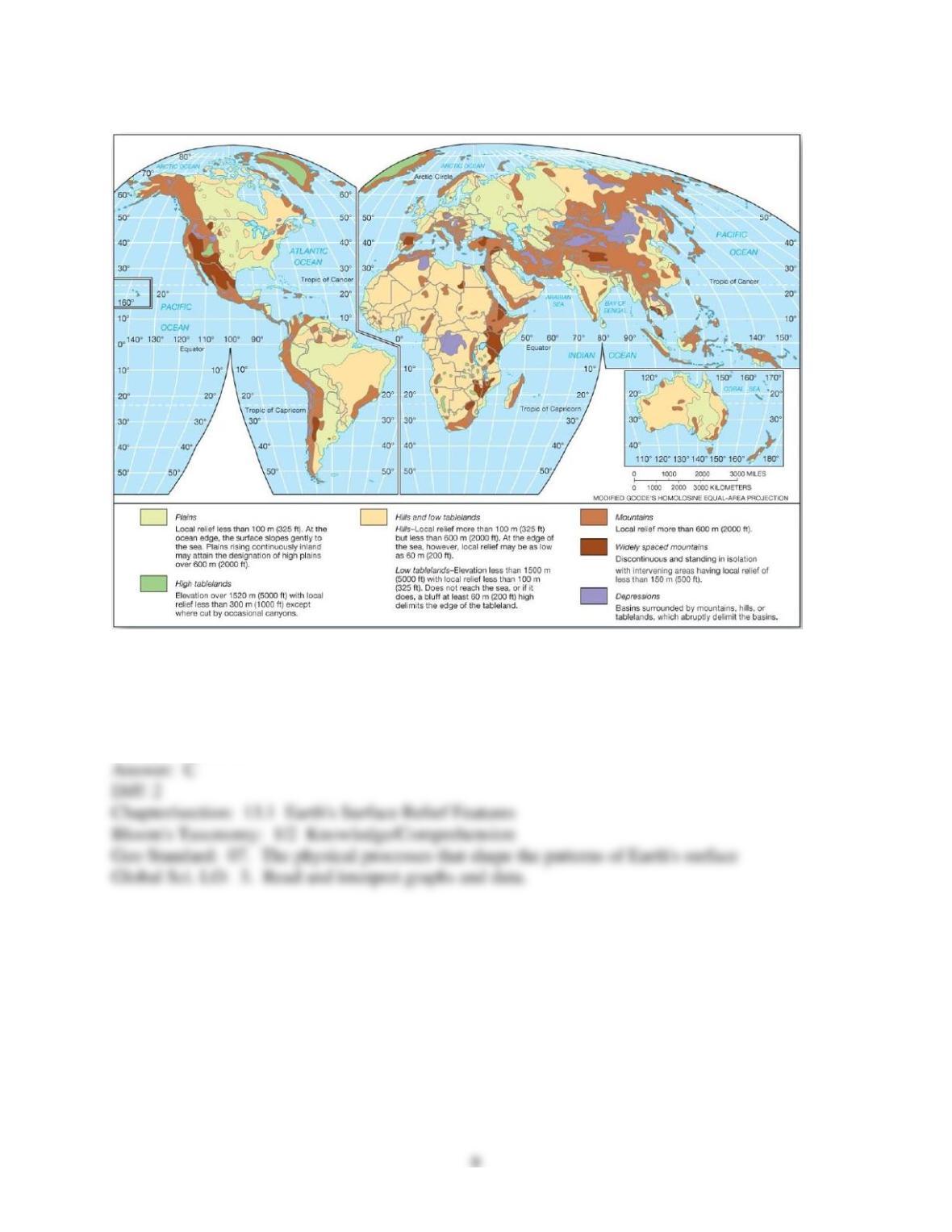
20)
Africa is dominated by which topographic region?
A) plains
B) mountains
C) hills and low tablelands
D) high tablelands
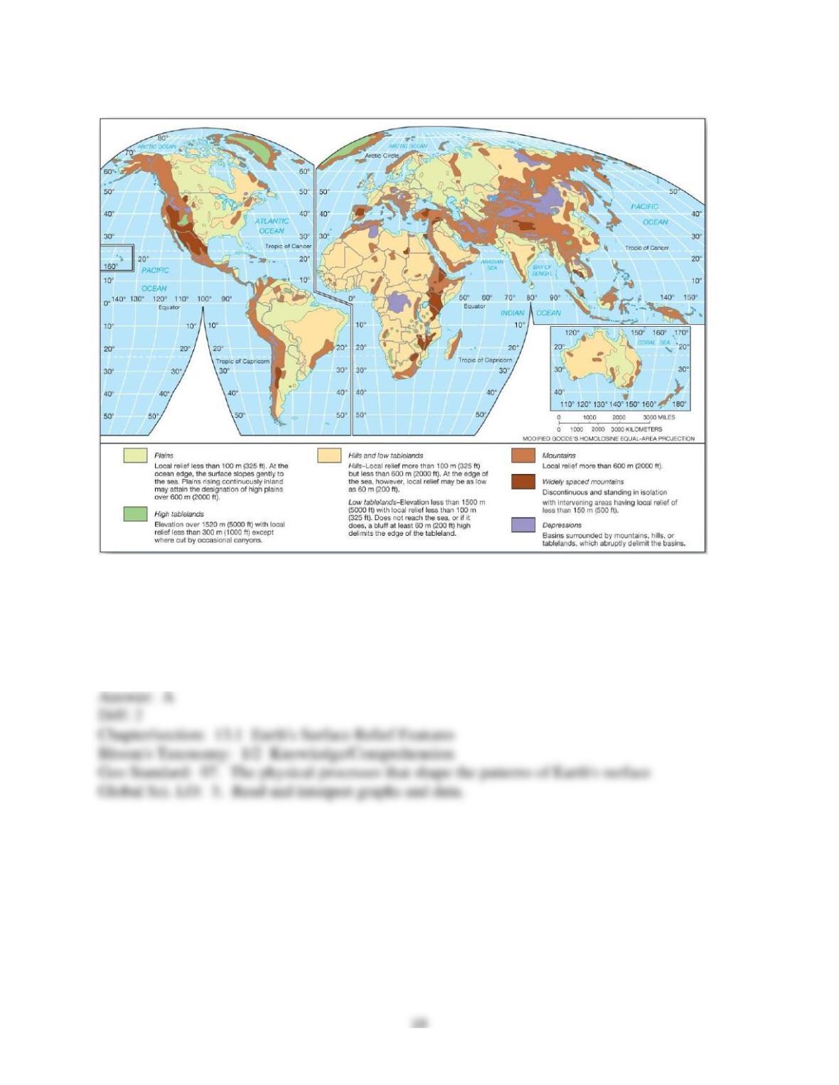
21)
Large portions of North and South America, Asia, and Australia are dominated by which
topographic region?
A) plains
B) basins
C) widely space mountains
D) high tablelands

22)
Large areas of high tablelands are found in
A) Africa.
B) Australia.
C) Greenland.
D) Central Asia.
12
23)
Large areas of depressions are found in
A) North America.
B) Asia.
C) Australia.
D) Antarctica.
24) The variety of surface features on Earth results from
A) endogenic processes only.
B) exogenic processes only.
C) Both endogenic and exogenic processes.
25) A continental craton is best described as
13
A) the product of active folding and faulting.
B) the surface accumulation of molten rock.
C) the inactive remains of ancient tectonic activity.
D) a landform undergoing constant tectonic activity.
26) The nucleus of old crystalline rock in each of the principal continental masses is called a
A) basalt mass.
B) continental shield, or craton.
C) mountain mass.
D) composite zone.
27) Most cratons date to the
A) Precambrian eon.
B) Paleozoic era.
C) Devonian period.
D) Paleocene epoch.
28) If you wanted to avoid earthquakes, which of the following areas would be the safest to live?
A) convergent plate boundary
B) divergent plate boundary
C) island arc along a subduction zone
D) shield
29) The general term used to describes subducted oceanic crusts that incorporates seawater and
sediments is
A) sial.
B) sima.
C) batholiths.
D) melt.
30) Which of the following properly describes the formation of continental crust?
A) All continental crust was formed millions of years ago. There is no active continental crust
being formed.
B) The formation of continental crust is independent of the formation of oceanic crust, involving
only volcanism over the land masses.
C) The formation of continental crust involves the entire sequence of seafloor spreading,
subduction, remelting of oceanic crust, and subsequent rise of the remelted material.
D) New continental crust is formed essentially in the same many as oceanic crust — from
upwelling at mid-continental ridges.
31) Terranes refer to
A) the topography of a tract of land.
B) subducted oceanic crust that is melted and later reaches the surface in volcanic eruptions or
cools in the subsurface as an intrusive body.
C) fragmented crustal material from one plate and accreted to another plate.
D) a large region where a craton is exposed at the surface.
32) Which of the following is not correct regarding terranes?
A) They are smaller-scale migrating crustal pieces; i.e., microplates.
B) They may accrete onto continents and thereby increase the size of the continents.
C) They are framed by fracture zones.
D) They are very similar in composition to the continents to which they attach.
E) They can move thousands of miles from their place of origin.
33) The Wrangellia terranes refer to
A) a former volcanic island arc that migrated 10,000 km (6200 mi.) to its present location along
the western margin of North America.
B) a terrane in southern Tibet that migrated to the region during the Palezoic from Australia.
C) a mountain range that became part of the Himalayas.
D) pieces of crust that moved with the Pacific plate to their present location near Japan.
34) Which of the following is incorrectly matched?
A) tension — normal fault
B) compression — shortening or folding
C) tension — stretching or faulting
D) shearing — stretching or faulting
35) Strain, the amount of deformation undergone by an object, is expressed in rocks by
A) metamorphism.
B) breaking and removal.
C) folding or faulting.
D) bending.
36) Folded layers of rock can form a wavelike pattern of troughs and crests. The layers near the
crest (i.e. the upward fold) form
A) a syncline.
B) a tension zone.
C) an anticline.
D) a thrust fault.
37) Folded layers of rock can form a wavelike pattern of troughs and crests. The layers near the
trough (i.e. downward fold) form
A) a syncline.
B) a tension zone.
C) an anticline.
D) a thrust fault.
38) The horizontal line that defines the portion of the anticline or syncline with the maximum
curvature is known as the
A) valley.
B) hinge.
C) trough.
D) basin.
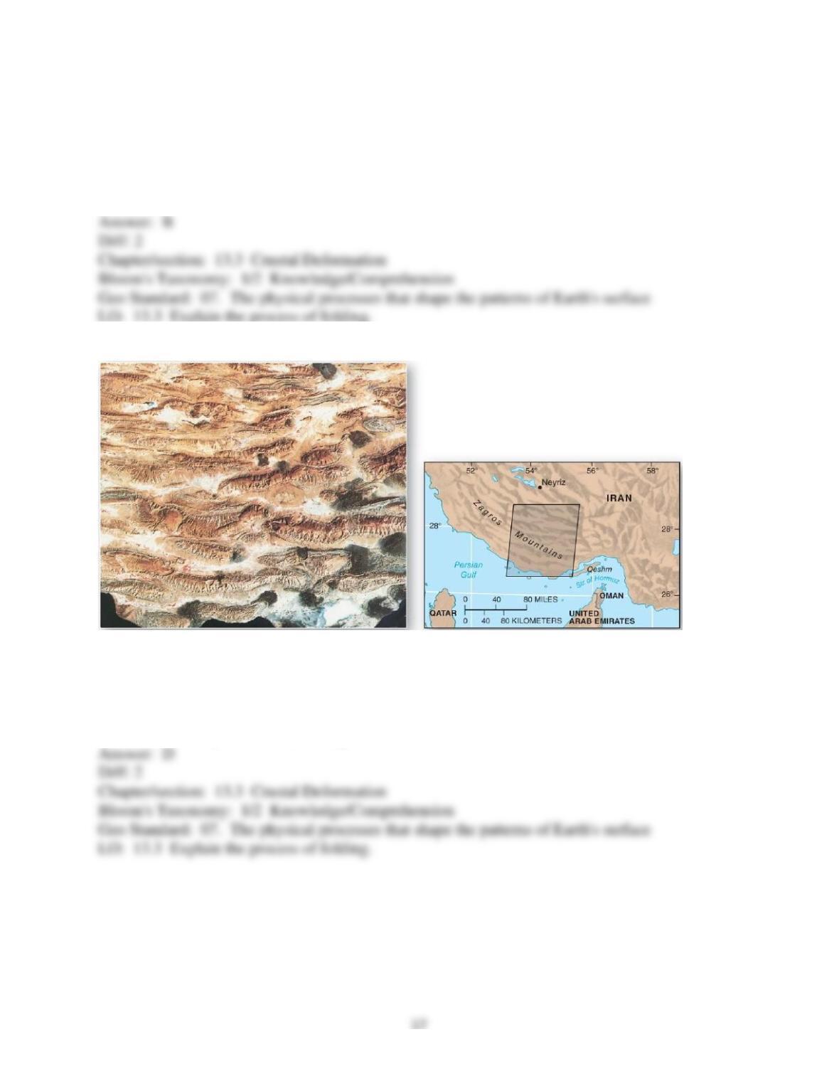
39)
The Zagros mountains of Iran is an example of
A) a series of faulted mountain blocks.
B) a zone of tension.
C) a zone of shearing motions.
D) a zone of compression and folding.

40) High mountains consisting of tightly folded and overthrust sedimentary rock layers, as well
as metamorphic rocks, are formed
A) along midocean ridges during seafloor spreading activity and are subsequently uplifted above
sea level in response to isostatic processes.
B) during plate collisions.
C) during volcanic eruptions.
D) in continental rift zones.
E) exclusively by magma intrusions.
41) Warping produces bends in rocks that are ________ those produced by folding.
A) larger than
B) smaller than
C) the same size as
42) Which of the following is a cause of warping?
A) mantle convection
B) hot spots
C) isostatic adjustment
D) mantle convection, hot spots, and isostatic adjustment all cause warping
43) When rock strata are strained beyond their ability to remain an intact unit, displacement
occurs in a process known as
A) folding.
B) faulting.
C) broad warping.
D) stressing.
44) Fault types are defined by
A) the tilt and orientation of the fault plane.
B) the amount of movement along the fault plane.
C) the amount of energy liberated during movement.
D) the type of rock material in which they occur.
45) Tensional stress along a fault can result in a dropped hanging-wall block relative to the
footwall side, producing a
A) reverse fault.
B) thrust fault.
C) normal fault.
D) strike-slip fault.
46) Normal faults are associated with
A) tensional forces.
B) compressional forces.
C) plate convergence.
D) transcurrent forces.
47) Compressional stress along a fault resulting in rocks moving upward along the fault plane is
an example of a
A) reverse fault.
B) lateral fault.
C) normal fault.
D) strike-slip fault.
48) An exposed fault plane with significant vertical extent is known as
A) a fracture zone.
B) an escarpment.
C) dome.
D) anticline.


