Exam
Name___________________________________
MULTIPLE CHOICE. Choose the one alternative that best completes the statement or answers the question.
1)
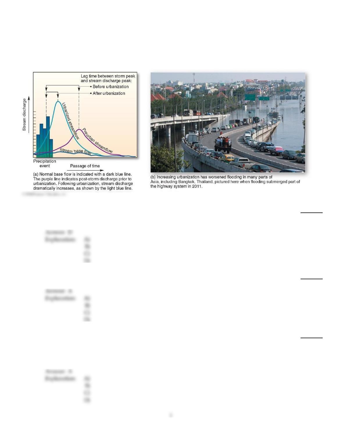
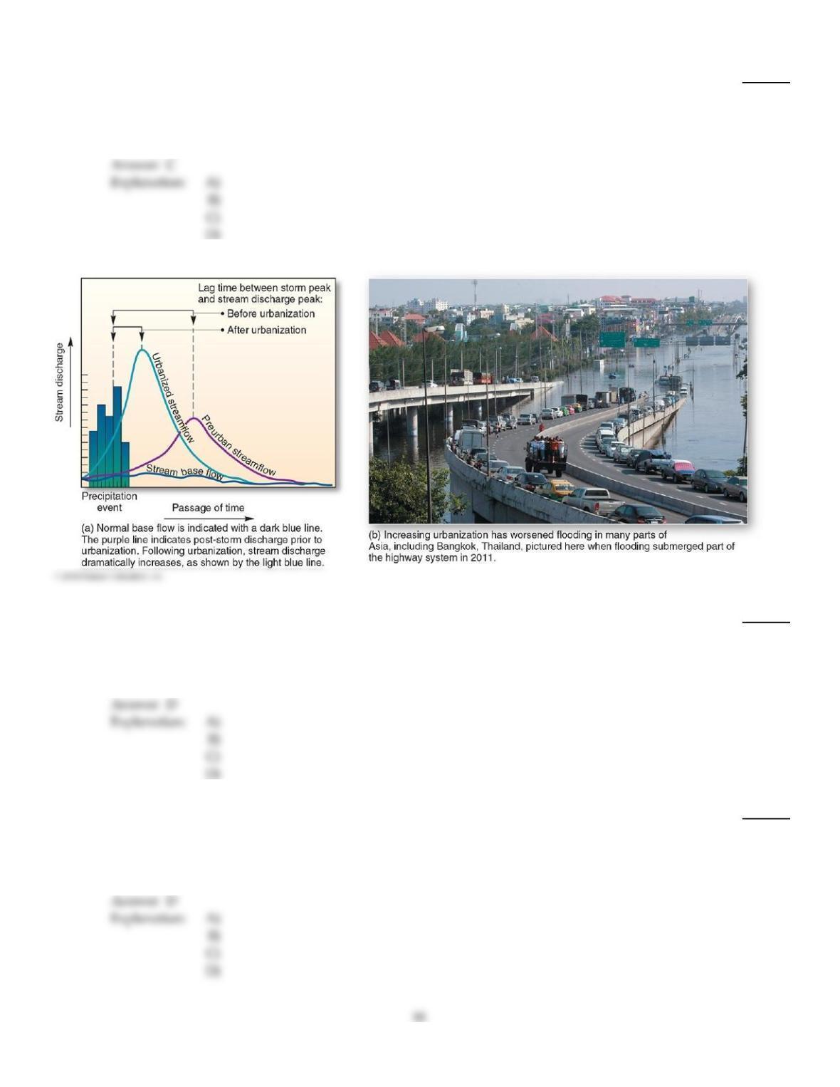
This graph, showing the effects of urbanization on streamflow over time, is an example of a
1)
A)
hydrological cycle.
B)
climograph.
C)
water budget.
D)
hydrograph.
2)
The drop in stream elevation per unit distance is known as
2)
A)
gradient.
B)
aspect.
C)
discharge.
D)
base level.
3)
The the idea of base level refers to
3)
A)
a level below which a stream cannot erode its valley.
B)
the amount of discharge in a particular reach of a stream.
C)
the average height of a stream channel.
D)
an evolutionary cycle of landscape development from fluvial action.
4)
The high ground that separates one valley from another and directs sheetflow is known as
4)
A)
an interfluve.
B)
the continental divide.
C)
drainage divide.
D)
the maximum contour elevation.
5)
The largest material that can be carried by a stream is carried as
5)
A)
flow load.
B)
suspended load.
C)
dissolved load.
D)
bed load.
6)
A basin in which water leaves via evapotranspiration or subsurface gravitational flow instead of
reaching the ocean is said to have
6)
A)
internal drainage.
B)
a closed system.
C)
sheetflow.
D)
a disappearing stream.
7)
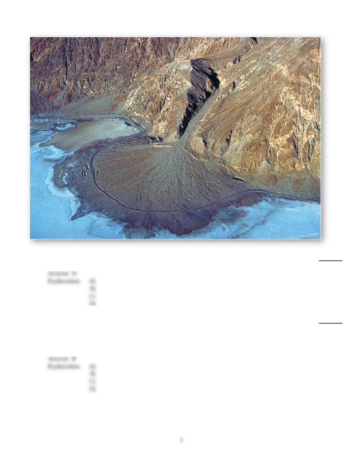
This landform results when water exists a constricted channel and loses velocity.
7)
A)
Meander scar
B)
Alluvial terrace
C)
Delta
D)
Alluvial fan
8)
As the discharge of a stream increases, which of the following also happens?
8)
A)
Stream channels narrow, become shallower, and lose velocity.
B)
Width, depth, and velocity all increase.
C)
The rate of flow decreases.
D)
Channel width increases but channel depth decreases.
9)
When a dam and reservoir are constructed, the natural response of the river and its channel
gradient come under the control of
9)
A)
the government.
B)
the same base level that existed prior to construction.
C)
a local, or temporary, base level.
D)
an ultimate base level.
10)
The sediment load consisting of fine–grained clastic particles held aloft in the stream is the
10)
A)
bed load.
B)
flow load.
C)
suspended load.
D)
dissolved load.
11)
The sediment load consisting of coarse material too large to remain in suspension, moving along
the channel bottom via traction and saltation is the
11)
A)
dissolved load.
B)
suspended load.
C)
flow load.
D)
bed load.
12)
A central peak, such as a volcanic mountain, generally produces a ________ drainage pattern.
12)
A)
trellis
B)
radial
C)
parallel
D)
annular
13)
The sediment load that travels in solution is
13)
A)
suspended load.
B)
flow load.
C)
bed load.
D)
dissolved load.
14)
The portion of each meandering curve subject to the slowest water velocity undergoes aggradation.
This results in a(n)
14)
A)
point bar.
B)
oxbow.
C)
cutback.
D)
meander scar.
15)
Natural levees are created during
15)
A)
degradation.
B)
normal flow conditions.
C)
low flow conditions.
D)
floods.
16)
Watersheds are defined by
16)
A)
continental divides.
B)
stream orders.
C)
drainage divides.
D)
fluvial units.
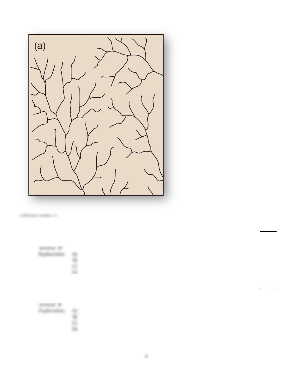
17)
This tree–like drainage pattern efficiently moves water and sediment through its system due to
minimization of the total length of each branch.
17)
A)
Radial
B)
Trellis
C)
Deranged
D)
Dendritic
18)
The entrenchment of a river into its own floodplain produces
18)
A)
river deltas.
B)
alluvial terraces.
C)
backswamps.
D)
natural levees.
19)
The area of land from which all water in it drains into the same place is known as a(n)
19)
A)
interfluve.
B)
drainage divide
C)
watershed.
D)
fluvial units.
20)
The degradation of a landscape by weathering, erosion, and transportation will ultimately reduce
the landscape down to
20)
A)
valley level.
B)
base level.
C)
continental shelf.
D)
the mountain tops.
B
21)
A(n) ________ is a stream that maintains an equilibrium between the processes of erosion and
deposition and, therefore degradation and aggradation.
21)
A)
graded stream
B)
anabranching river
C)
oxbow
D)
meandering stream
A
22)
Maximum velocity in a meandering stream is
22)
A)
at the inner portion of the meander curve.
B)
near the bottom.
C)
at the outer portion of the meander curve.
D)
at the center and near the surface.
C
23)
Excess sediment may result in which of the following channel patterns?
23)
A)
Braided stream
B)
Meandering stream
C)
V–shaped valleys
D)
Straight, steep–walled channels
A
C
24)
A(n) ________ is a meander that becomes isolated from the rest of the river.
24)
A)
cutoff
B)
point bar
C)
oxbow lake
D)
undercut bank
25)
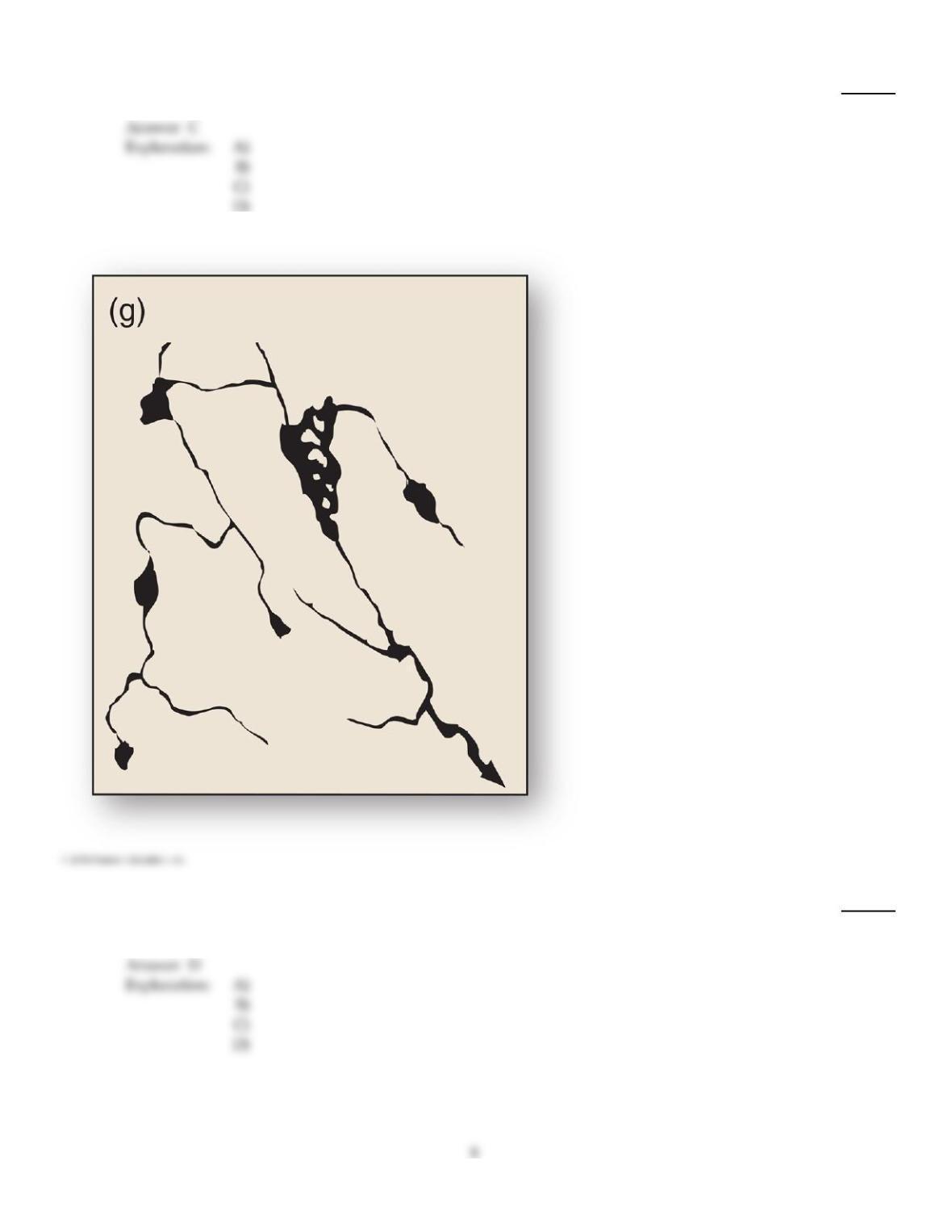
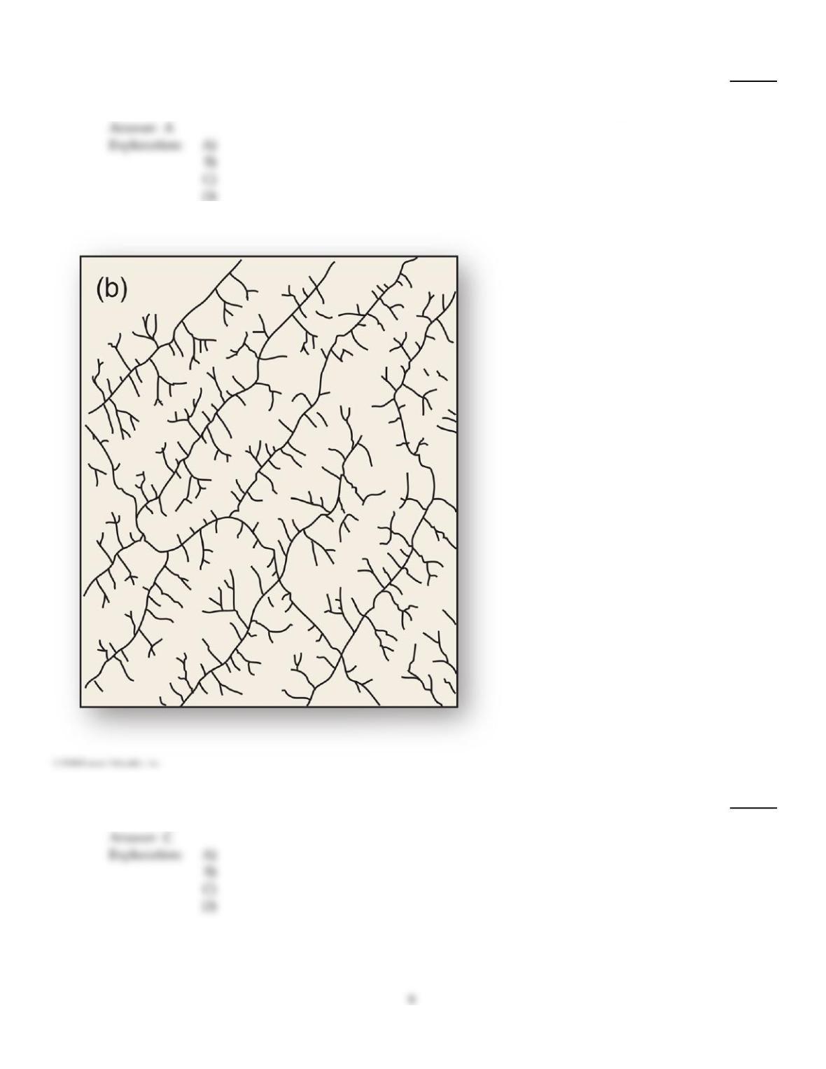
With no clear geometry and no true stream valley, this drainage pattern occurs in areas such as
glaciated shield regions.
25)
A)
Dendritic
B)
Parallel
C)
Radial
D)
Deranged
26)
________ streams are not connected to groundwater systems and only flow after precipitation
events.
26)
A)
Ephemeral
B)
Perennial
C)
Intermittent
D)
Temporary
27)
This drainage pattern is characteristic of dipping or folded topography.
27)
A)
Rectangular
B)
Radial
C)
Trellis
D)
Annular
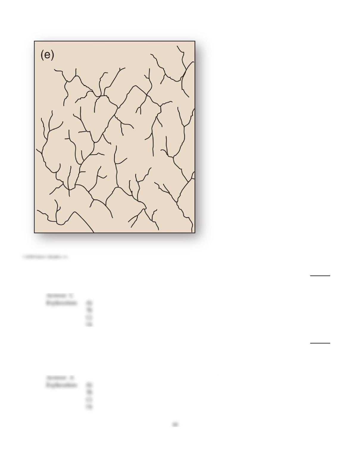
28)
Faulted and jointed landscapes directs streams courses in patterns of right–angle turns forming this
drainage pattern.
28)
A)
Trellis
B)
Dendritic
C)
Rectangular
D)
Radial
29)
If you live in an area that was flooded by the 100–year flood last year, you can conclude that
29)
A)
there is a 1% chance you could be flooded by the 100–year flood again this year.
B)
the next 100–year flood will occur in exactly 100 years.
C)
the next 100–year flood will occur in exactly 99 years.
D)
you do not have to worry about another flood of that size during your lifetime.

30)
The general term for channelized water flow, regardless of size, is
30)
A)
rill.
B)
gully.
C)
stream.
D)
river.
31)
A drainage divide that separates drainage basins that empty into different bodies of water
surrounding a continent are known as
31)
A)
continental divides.
B)
deltas.
C)
interfluves.
D)
catchments.
A
32)
A 50–year flood has an annual exceedance probability of
32)
A)
50%.
B)
0.5%.
C)
5%.
D)
25%.
C
33)
Alluvial fans are formed as flowing water ________ as it leaves a constricted channel.
33)
A)
down cuts
B)
gains velocity
C)
changes direction
D)
loses velocity
D
34)
Steep slopes and some relief generally produce which drainage pattern?
34)
A)
Deranged
B)
Parallel
C)
Annular
D)
Dendritic
B
C
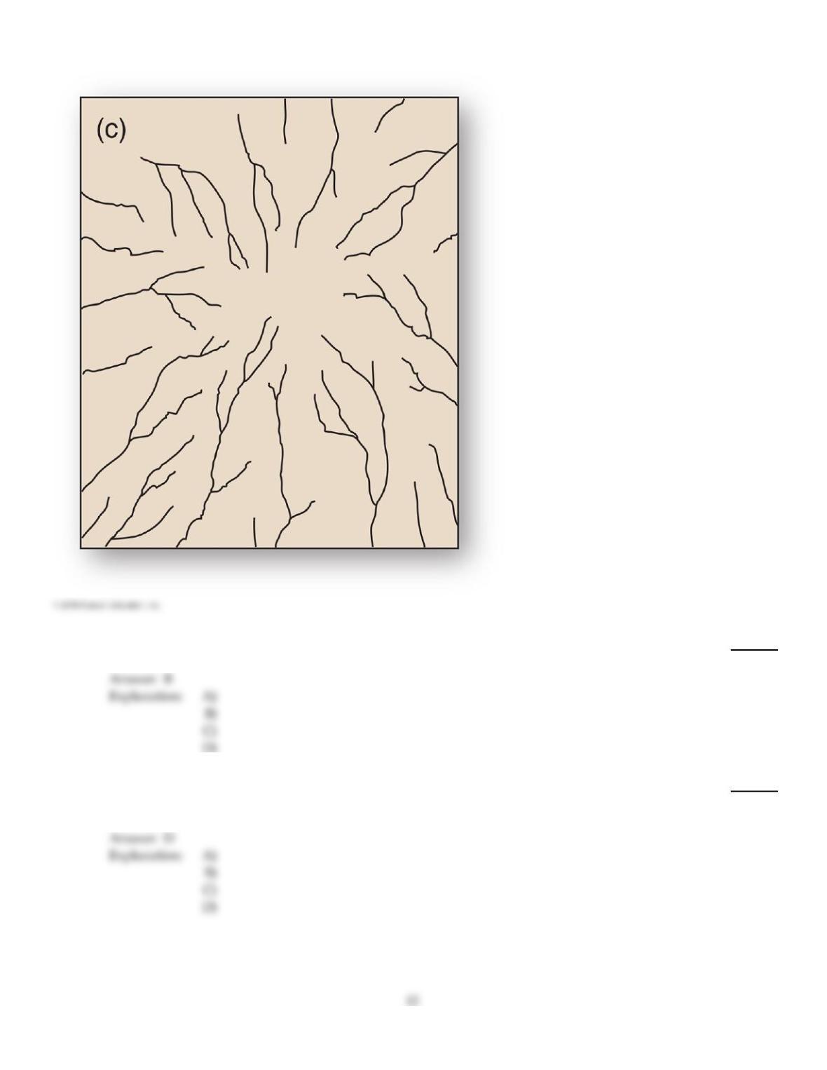
35)
This drainage pattern results when streams flow off a central peak or dome.
35)
A)
Trellis
B)
Radial
C)
Annular
D)
Rectangular
36)
Cone–shaped deposits of sediment often found at mouth of canyons in arid and semiarid climates
are called
36)
A)
deltas.
B)
clastics.
C)
deposition.
D)
alluvial fans.
37)
A cutoff on a meandering stream results in the formation of
37)
A)
a levee.
B)
a terrace.
C)
an oxbow lake.
D)
a braided stream.
E)
a point bar.
38)
Which of the following lists of processes are in the CORRECT sequence from beginning to end?
38)
A)
Deposition, erosion, transport, weathering
B)
Weathering, deposition, erosion, transport
C)
Weathering, erosion, transport, deposition
D)
Weathering, erosion, deposition, transport
39)
Which of the following is INCORRECTLY matched?
39)
A)
Aggradation sediment accumulation in the stream channel
B)
Cutbank outer portion of a stream meander
C)
Point bar area of substantial erosion
D)
Braided stream maze of interconnected channels
40)
The total possible load a stream can transport is its ________, whereas a stream’s ability to move
particles of specific size is its ________.
40)
A)
discharge; competence
B)
bed load; sediment load
C)
capacity; competence
D)
competence; capacity
41)
If the load exceeds a stream’s capacity, sediment accumulates in the bed in a process called
41)
A)
degradation.
B)
downcutting.
C)
saltation.
D)
aggradation.
42)
The ultimate base level is
42)
A)
sea level.
B)
dependent on the geological substrate.
C)
a drainage divide.
D)
a dam.
A
43)
The process whereby streams deepen their channel is known as
43)
A)
stream piracy
B)
headwater erosion.
C)
saltation.
D)
channel incision.
D
44)
Which of the following tends to occur when an area experiences tectonic uplift in its headwater
region?
44)
A)
The stream will begin to deposit more of its load.
B)
The amount of turbulence will decrease.
C)
The stream will lose energy.
D)
The channel will begin to erode downward at a faster rate.
D
45)
Which of the following is INCORRECT regarding floodplains?
45)
A)
They are characterized by rapids and low waterfalls.
B)
They are formed by recurrent flooding in the area adjacent to the stream.
C)
Natural levees on either side of a stream are formed during times when the stream is at flood
stage and overflows the bank.
D)
They are generally low–lying areas.
A
D

46)
Overland flow can concentrate in small grooves called ________, which can enlarge to form
________.
46)
A)
striations; gullies
B)
gullies; rills
C)
potholes; striations
D)
striations; potholes
E)
rills; gullies
47)
Which of the following is CORRECT of a floodplain?
47)
A)
Despite the name, they are rarely subjected to flooding.
B)
Floodplains are not associated with deposition.
C)
It is an erosional feature located within a depositional feature.
D)
It is generally filled with layers of alluvium.
48)
Which of the following is INCORRECTLY matched?
48)
A)
Competence a stream’s ability to move particles of a specific size
B)
Capacity the total possible load that a stream can transport
C)
Particles rolled and bounced along a stream bed saltation
D)
Abrasion a hydraulic squeeze–and–release action
E)
Fine particles physically held aloft in a stream suspended load
49)
The main process contributing material in solution in sediment load is
49)
A)
chemical weathering.
B)
biological weathering.
C)
erosion.
D)
physical weathering.
50)
A yazoo tributary stream cannot join with the main river in an area because
50)
A)
a man–made flow control structure keeps the rivers separate.
B)
a small structural ridge separates the rivers.
C)
a natural levee on the main river prevents its joining.
D)
the yazoo flows in a different valley.
51)
The effect of urbanization on a typical stream hydrograph is to
51)
A)
decrease runoff.
B)
create a base flow.
C)
increase lag time between storm peak and peak stream discharge.
D)
decrease lag time between storm peak and peak stream discharge.
52)
Rectangular drainage patterns form primarily as a result of
52)
A)
differential resistance to erosion.
B)
flow through anticlinal and synclinal topography.
C)
domal uplift.
D)
flow through a faulted landscape.
53)
Which of the following is CORRECT of the longitudinal profile of most rivers?
53)
A)
It is convex in shape.
B)
It always changes at a constant rate from the headwater region to the sea.
C)
It is concave in shape.
D)
It is gentle upstream and steep downstream.
54)
Of the world’s largest rivers, which has the greatest discharge?
54)
A)
Missouri–Ohio–Mississippi river system
B)
Chang Chiang (Yangtze) of Asia
C)
Amazon River
D)
Zaire (Congo) River
Explanation:
55)
Drainage basins are ________ systems.
55)
A)
open
B)
closed
C)
open in terms of energy, closed in terms of matter
D)
closed in terms of energy, open in terms of matter
Explanation:
56)
A stream’s volume of flow per unit of time is its
56)
A)
speed.
B)
flow rate.
C)
velocity.
D)
discharge.
Explanation:
57)
Bed load is moved by
57)
A)
traction.
B)
saltation.
C)
suspension.
D)
saltation, traction, and suspension
E)
both saltation and traction, but not suspension.
Explanation:
Explanation:
58)
If a stream originates in a humid region, but subsequently flows through an arid region, discharge
is likely highest
58)
A)
midstream.
B)
at an estuary or confluence with another stream.
C)
upstream.
D)
downstream.
59)
An interruption in a stream’s graded profile of equilibrium is called a
59)
A)
base level.
B)
gradation.
C)
longitudinal interruption.
D)
nickpoint.
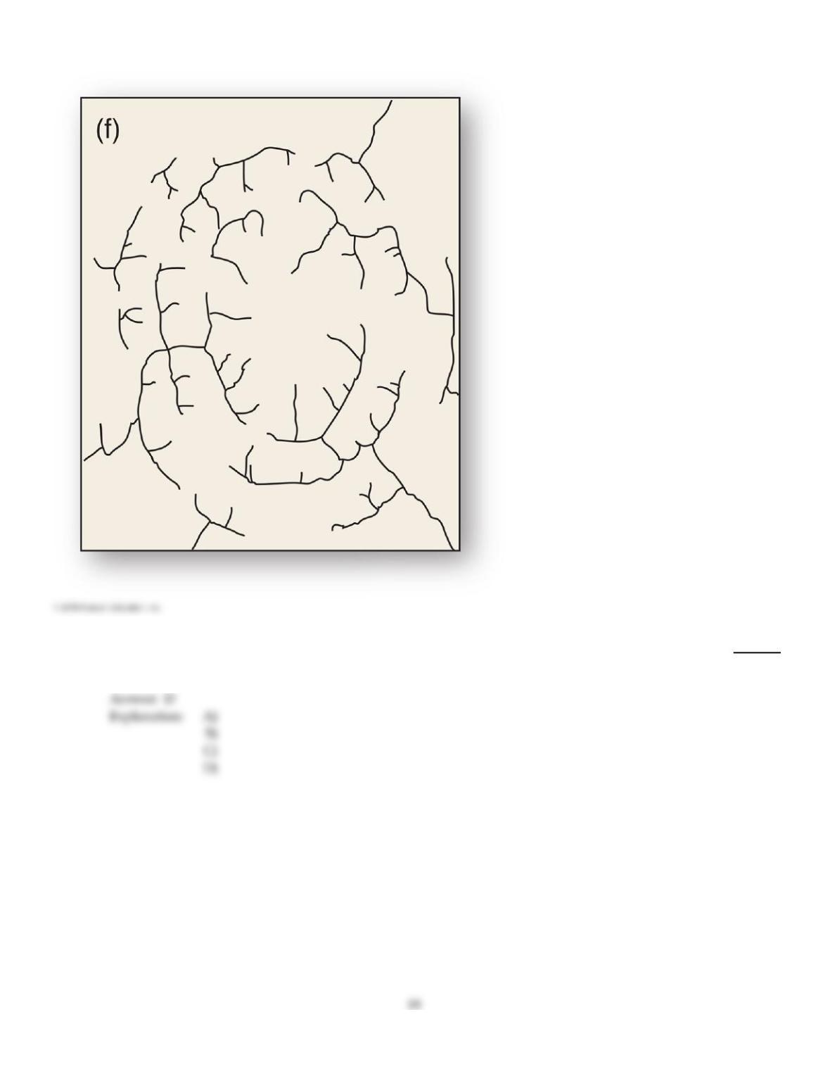
60)
Structural domes with concentric patterns of rock strata guide stream courses to form this drainage
pattern.
60)
A)
Dendritic
B)
Radial
C)
Parallel
D)
Annular
61)
Which of the following best describes the relationship of deforestation to sediment load?
61)
A)
Trees roots help “anchor” soil; as the trees are removed, the soil more readily erodes into the
river channels.
B)
Forestry waste is often dumped in streams, contributing to the suspended loads.
C)
Trees provide dissolved sediments to the stream; as trees are removed, the dissolved loads are
diminished.
D)
The loss of trees along banks of streams increases stream velocity.
62)
What is the drainage density of a 100 mi2 drainage basin with 25 miles of stream, running through
three rivers?
62)
A)
0.25 mi./mi2.
B)
33.333.
C)
4 mi./mi2.
D)
3.
A
63)
A drainage system that maintains its original course and pattern as it erodes into older underlying
rock of a different geological structure is called a(n)
63)
A)
discordant stream.
B)
superposed stream.
C)
annular pattern.
D)
deranged pattern.
B
64)
Drainage density is determined by
64)
A)
dividing the total length of all stream channels in a basin by the area of the basin.
B)
averaging the discharge values across a drainage basin.
C)
dividing the number of streams in a basin by the basin area.
D)
dividing the actual path length of a stream by the shortest path length of the stream.
A
A
65)
The downstream portion of a river
65)
A)
generally is of higher velocity, although it is masked by reduced turbulence.
B)
has lower discharges than do upstream portions.
C)
generally becomes more sluggish.
D)
features greater hydraulic action than do upstream portions.
66)
Drainage density refers to
66)
A)
the thickness of the water in the stream.
B)
the arrangement of channels in a given area.
C)
the number of channels in an area.
D)
a measure determined by dividing the length of all the the channels by the area of its drainage
basin.
D
67)
Which is typical of a rejuvenated system?
67)
A)
Oxbow lakes
B)
Entrenched meanders
C)
Terraces
D)
Increased downcutting
E)
Entrenched meanders, increased downcutting and terraces
E
68)
When a river reaches a base level, its forward velocity rapidly decelerates as it enters a larger body
of standing water and ________ is formed.
68)
A)
an estuary
B)
a stream terrace
C)
a delta
D)
an alluvial terrace
C
A
69)
A meandering stream is one that is
69)
A)
completely stable.
B)
completely unstable.
C)
closed in terms of energy and matter input.
D)
delicately balanced between equilibrium and chaos.
70)
A squeeze–and–release action works to loosen and lift rocks in a stream channel. This is an
example of
70)
A)
deposition.
B)
suspension.
C)
abrasion.
D)
hydraulic action.
Explanation:
71)
The science of water and its global circulation, distribution, and properties is known as
71)
A)
geomorphology.
B)
hydrology.
C)
climatology.
D)
lithology.
Explanation:
Explanation:
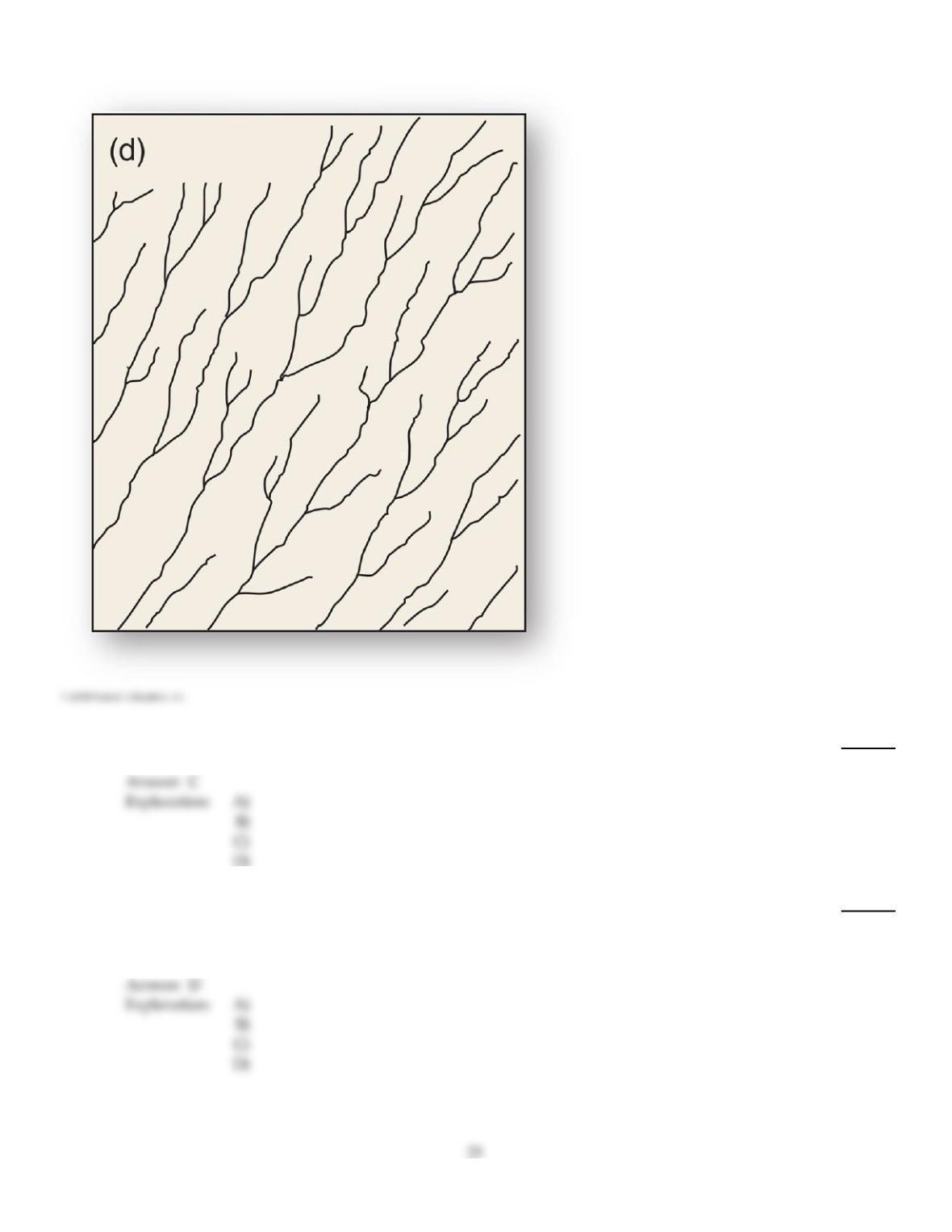
72)
This drainage pattern is associated with steep slopes.
72)
A)
Deranged
B)
Dendritic
C)
Parallel
D)
Trellis
73)
A stream that downcuts at the same rate as tectonic uplift, thereby maintaining its course is called
a(n)
73)
A)
meandering stream.
B)
rejuvenated river.
C)
anabranching river.
D)
antecedent stream.
74)
Which of the following is NOT factored when considering discharge?
74)
A)
Channel length
B)
Velocity
C)
Channel width
D)
Channel depth
75)
In most river basins in humid regions, discharge is highest
75)
A)
at the headwaters.
B)
downstream.
C)
midstream.
D)
upstream.
76)
A mass of water above base level in a stream has ________ energy; as it flows downstream, this
energy becomes ________ energy.
76)
A)
kinetic; potential
B)
potential; kinetic
C)
kinetic; kinetic
D)
potential; potential
77)
Channels with gradual slopes often develop a sinuous form called a ________ pattern.
77)
A)
braided stream
B)
meandering stream
C)
anabranching
D)
straight
78)
As a stream‘s velocity decreases, which of the following sizes of sediments will be deposited last?
78)
A)
Sand
B)
Silt
C)
Clay
D)
Gravel
79)
The suspended load of a stream consists of particles that are
79)
A)
rolled and bounced along the stream bed.
B)
dragged along the stream bed.
C)
dissolved in solution.
D)
held aloft in the stream flow.
80)
Which of the following landforms is INCORRECTLY matched with a drainage pattern?
80)
A)
Topographically disrupted areas parallel
B)
Folded mountain belt trellis
C)
Volcano radial
D)
Eroded dome annular
81)
A tributary that is physically unable to join the main channel on a floodplain due to natural levees
is called a
81)
A)
yazoo tributary.
B)
meandering tributary.
C)
alluvial stream.
D)
levee tributary.
82)
The average size of sediment in a natural levee is ________ that found in the surrounding
floodplain.
82)
A)
larger than
B)
the same size as
C)
smaller than
83)
Stream transport involves all of the following EXCEPT
83)
A)
bed load.
B)
saltation.
C)
traction.
D)
sheet flow.

84)
A stream becomes graded when
84)
A)
its basin becomes rejuvenated.
B)
a local base level controls the stream.
C)
erosion and deposition are in equilibrium.
D)
a river achieves a longitudinal stream profile of a steeper upstream portion.
85)
Entrenchment of a channel occurs because
85)
A)
a decrease in stream gradient occurs.
B)
isostatic downwarping of the crust occurs.
C)
a change in the bed load size–distribution occurs.
D)
the river flows from consolidated rock into a region composed of loose sediments.
E)
rejuvenation occurs due to uplift.
86)
Stream drainage patterns are determined by which of the following?
86)
A)
Variations in rock resistance
B)
Climate
C)
Regional steepness and relief
D)
Climate, regional steepness and relief, and variations in rock resistance
87)
Maximum velocity in a straight channel is found
87)
A)
at the center and near the surface, corresponding with the shallowest parts of the stream
channel.
B)
near the bottom.
C)
at the center and near the surface, corresponding with the deepest parts of the stream channel.
D)
near the inside of a meander.

88)
________ streams have some groundwater input, but only flow for certain periods during a year.
88)
A)
Ephemeral
B)
Temporary
C)
Intermittent
D)
Perennial
89)
As they migrate, meandering streams erode their out outside banks, often forming a narrow neck of
land that eventually erodes through and forms a ________ and the stream becomes ________.
89)
A)
cutoff; straighter
B)
cutback; more sinuous
C)
point bar; wider
D)
meander scar; narrower
90)
Which of the following may act as a local base level?
90)
A)
The upper surface of a waterfall
B)
A drainage divide
C)
An interfluve
D)
A lake that a river flows into
91)
Processes that are related expressly to streams and rivers are termed
91)
A)
geomorphic.
B)
limnetic.
C)
lotic.
D)
fluvial.
92)
The portion of each meandering curve subject to the fastest water velocity undergoes the greatest
erosive action. This action forms a steep
92)
A)
oxbow.
B)
cutback.
C)
point bar.
D)
meander scar.
93)
The statistical rating of flood discharge is based on
93)
A)
historical records of discharge during precipitation events.
B)
average channel depth.
C)
floodplain width.
D)
the rate of aggradation or degradation of a stream.
94)
Which of the following is used to measure streamflow?
94)
A)
Statistical methods of probability
B)
Barometer and sling psychrometer
C)
Stilling well and staff gauge
D)
Reservoirs
95)
________ is the general term for unconsolidated clay, silt, sand, gravel, and mineral fragments
deposited by running water.
95)
A)
Deposition
B)
Aggradation
C)
Alluvium
D)
Degradation
96)
________ streams flow year–round, fed by snowmelt, rainfall, groundwater, or a combination
thereof.
96)
A)
Perennial
B)
Intermittent
C)
Permanent
D)
Ephemeral
97)
Which of the following is likely to occur if the gradient of a stream increases? (Assume that the
discharge and sediment load remain unchanged.)
97)
A)
The stream will begin to deposit more of its load.
B)
The amount of bed load transport will decrease.
C)
The amount of aggradation in the channel will increase.
D)
The stream will begin to erode its channel and/or its banks.

TRUE/FALSE. Write ‘T’ if the statement is true and ‘F’ if the statement is false.
98)
Only larger rivers and streams have their own drainage basins.
98)
99)
Physical weathering is the main process that contributes to the dissolved load of streams.
99)
100)
A 10–year flood has an annual exceedance probability of 10%.
100)
101)
The ultimate base level is sea level.
101)
102)
A graded stream is one that has achieved a dynamic equilibrium between degradation and
aggradation.
102)
103)
A perennial stream can go months and even years between flow events.
103)
104)
Stream velocity is often measured for different subsections of a stream using a moveable current
meter.
104)
105)
Because rivers constitute such a small percentage of Earth’s total water supply, they play a small
role in landform change.
105)
106)
The higher the sinuosity, the straighter the stream channel.
106)
107)
An alluvial terrace is evidence of aggradation.
107)
108)
The suspended load of a stream is the coarser materials that are dragged along the stream bed.
108)

109)
An oxbow lake is a former meander that has become isolated from the rest of the river.
109)
110)
A floodplain is composed of alluvium.
110)
111)
The mouth of a river is where the river reaches base level.
111)
112)
Rivers have played a relatively minor role in the geography of human history.
112)
113)
Erosion is a degrading process whereas deposition is an aggradating process.
113)
114)
Variations in rock resistance, climate, and hydrology can influence drainage patterns.
114)
115)
The meaning of the terms “river” and “stream” sometimes overlap although, in general, a river is a
large stream.
115)
116)
Drainage basins are closed systems in terms of matter.
116)
117)
Peak flow refers to the highest discharge that occurs during a precipitation event.
117)
118)
Stream drainage always eventually reaches the ocean.
118)
119)
Nickpoints migrate downstream.
119)
120)
Drainage divides control into which basin surface runoff drains.
120)

121)
A braided stream is indicative of excess sedimentation.
121)
122)
A flood recurrence interval of 100 years means that floods of that size will occur only once every
100 years.
122)
123)
In most rivers in humid regions, discharge increases downstream.
123)
124)
Alluvial fans are produced when flowing water loses velocity as it leaves a constricted canyon.
124)
125)
Terraces form when a river’s energy increases.
125)
126)
Erosion of the bank of a stream channel normally occurs on the outside curve of a meander.
126)
127)
Drainage basins may cross into multiple countries, compounding the difficulties in proper
watershed management.
127)
128)
Deforestation in the headwater regions of a river can cause the river to flood more frequently
downstream.
128)
129)
Floodplain formation occurs while a stream is downcutting rapidly.
129)
130)
A drainage basin is defined by ridges that form drainage divides.
130)
131)
In a straight channel, the greatest flow velocities are found along the bottom in the middle of the
stream.
131)
132)
Natural levees block yazoo streams from joining the main river on a flood plain.
132)
133)
Flood control often produces conditions of worse flooding in subsequent high–water events.
133)
134)
Base level refers to the average stream depth immediately following a normal precipitation event.
134)
135)
The construction of levees can actually increase the risk of a catastrophic flood.
135)
136)
Give the equation for stream discharge. What happens to stream velocity if discharge and depth remain the
same, but width increases?
137)
Define the following terms: drainage basis, drainage divide, interfluve, and valley.
138)
Describe the formation of alluvial fans and bajadas.
139)
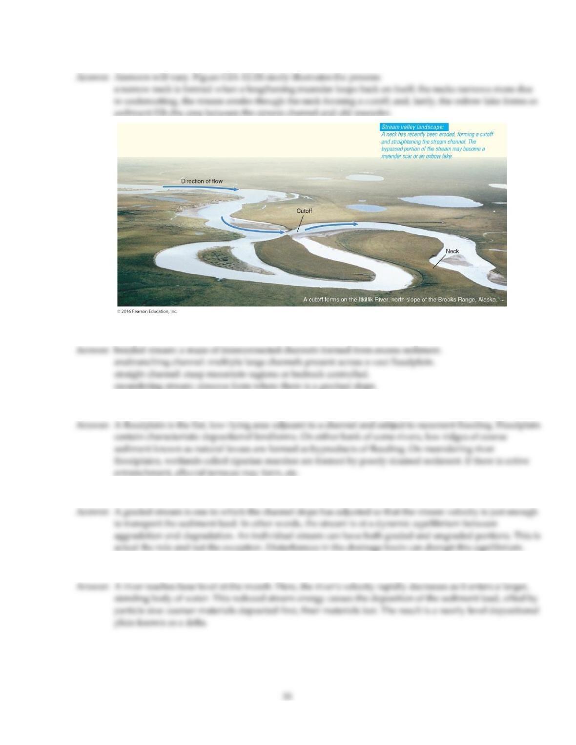
Describe or draw and label the stages of development of an oxbow lake, from meander bend to cut off to oxbow
lake, including the location of cut banks and point bars.
140)
Describe the common stream channel patterns.
141)
Describe the formation and typical characteristics of a floodplain.
142)
Discuss the concept of the graded stream. Do most streams approximate a graded stream? Why or why not?
143)
Describe the formation of deltas.
144)
Describe five common drainage patterns and the conditions that typically form them.
145)
Describe the various ways in which streams can transport material.
Answer Key
Testname: C12
35
Answer Key
Testname: C12
36

Answer Key
Testname: C12
37
Answer Key
Testname: C12
38