Exam
Name___________________________________
MULTIPLE CHOICE. Choose the one alternative that best completes the statement or answers the question.
1)
The energy released by a magnitude 8 quake on the Richter scale is how many times greater than
that of a magnitude 6 quake?
1)
A)
3.15
B)
31.5
C)
63
D)
992
E)
31,255
2)
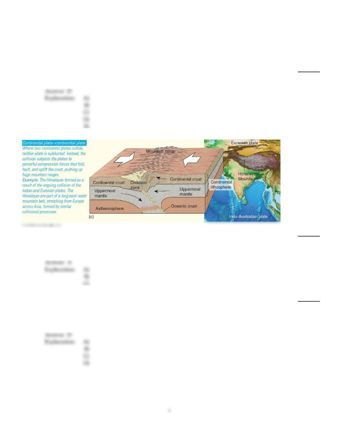
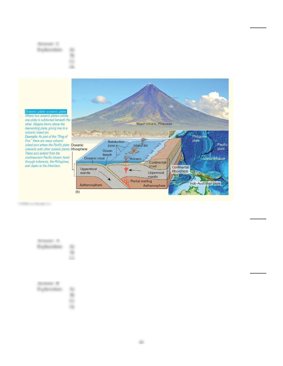
What type of convergent boundary associated with orogeny is illustrated here?
2)
A)
Continental plate–continental plate collision
B)
Oceanic plate–oceanic plate collision
C)
Oceanic plate–continental plate collision
3)
Increased seismicity in Colorado, New Mexico, and Oklahoma has been linked to
3)
A)
a continental plate–continental plate subduction zone.
B)
a strike–slip fault.
C)
a rift valley hot spot in the mid–continental region.
D)
injection wells associated with hydraulic fracturing.
4)
An earthquake is best described as
4)
A)
The point within Earth where seismic waves originate.
B)
The amount of ground displacement along a fault.
C)
the sharp release of energy in Earth’s crust that creates seismic waves.
D)
The amount of stress rocks along plate boundaries experience.
5)
Normal faults are associated with
5)
A)
compressional forces.
B)
transcurrent forces.
C)
tensional forces.
D)
plate convergence.
6)
Volcanic activity generally does NOT occur
6)
A)
in association with hot spots over plumes in the mantle.
B)
along subduction boundaries.
C)
in association with plutons.
D)
along sea–floor spreading centers.
7)
The horizontal line that defines the portion of the anticline or syncline with the maximum
curvature is known as the
7)
A)
valley.
B)
trough.
C)
basin.
D)
hinge.
8)
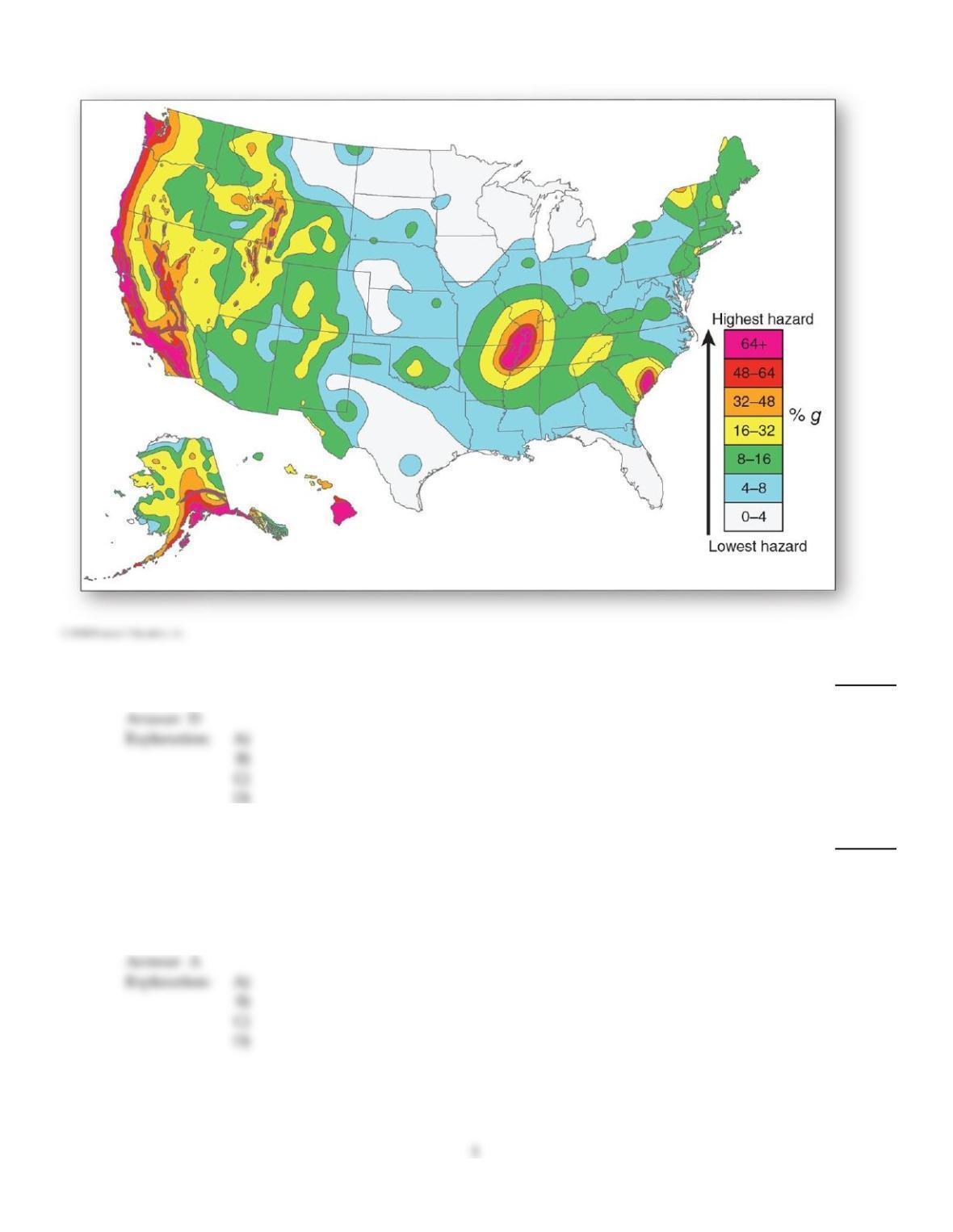
Within the United States, which area has the highest earthquake hazards?
8)
A)
East Coast
B)
Mid–continent.
C)
Gulf Coast
D)
West Coast
9)
The Wrangellia terranes refer to
9)
A)
a former volcanic island arc that migrated 10,000 km (6200 mi.) to its present location along
the western margin of North America.
B)
pieces of crust that moved with the Pacific plate to their present location near Japan.
C)
a mountain range that became part of the Himalayas.
D)
a terrane in southern Tibet that migrated to the region during the Paleozoic from Australia.
10)
________ applies to upward–faulted blocks, whereas ________ applies to downward–faulted
blocks.
10)
A)
Thrust; normal
B)
Graben; horst
C)
Normal; thrust
D)
Horst; graben
11)
The most detailed order of relief applies to ________ order relief features.
11)
A)
first
B)
second
C)
third
12)
Which of the following is NOT used to rate an earthquake on the moment magnitude scale?
12)
A)
The nature of the ground materials affected by the quake
B)
The amount of fault slippage that occurred
C)
The amount of death and destruction that occurred
D)
The size of the subsurface or surface area that ruptured
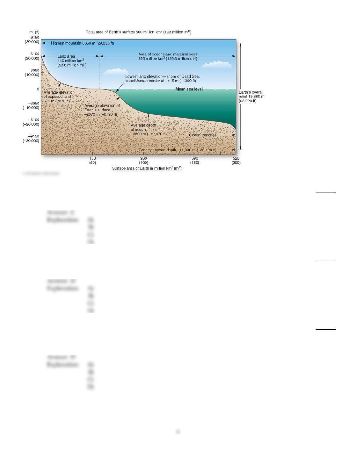
13)
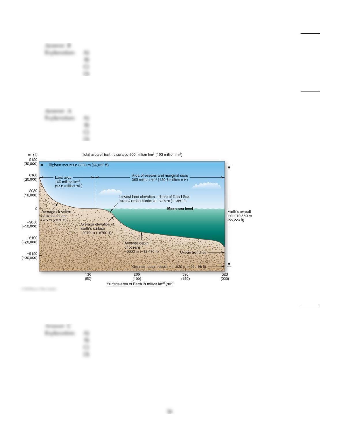
The average elevation of the depth of the oceans is
13)
A)
875 m (2870 ft.).
B)
100 m (325 ft.).
C)
–3800 m (–12,470 ft.).
D)
–2070 m (–6790 ft.).
14)
The average elevation of the exposed land is
14)
A)
–2070 m (–6790 ft.).
B)
100 m (325 ft.).
C)
–3800 m (–12,470 ft.).
D)
875 m (2870 ft.).
15)
Compressional stress along a fault resulting in rocks moving upward along the fault plane is an
example of a
15)
A)
normal fault.
B)
lateral fault.
C)
strike–slip fault.
D)
reverse fault.
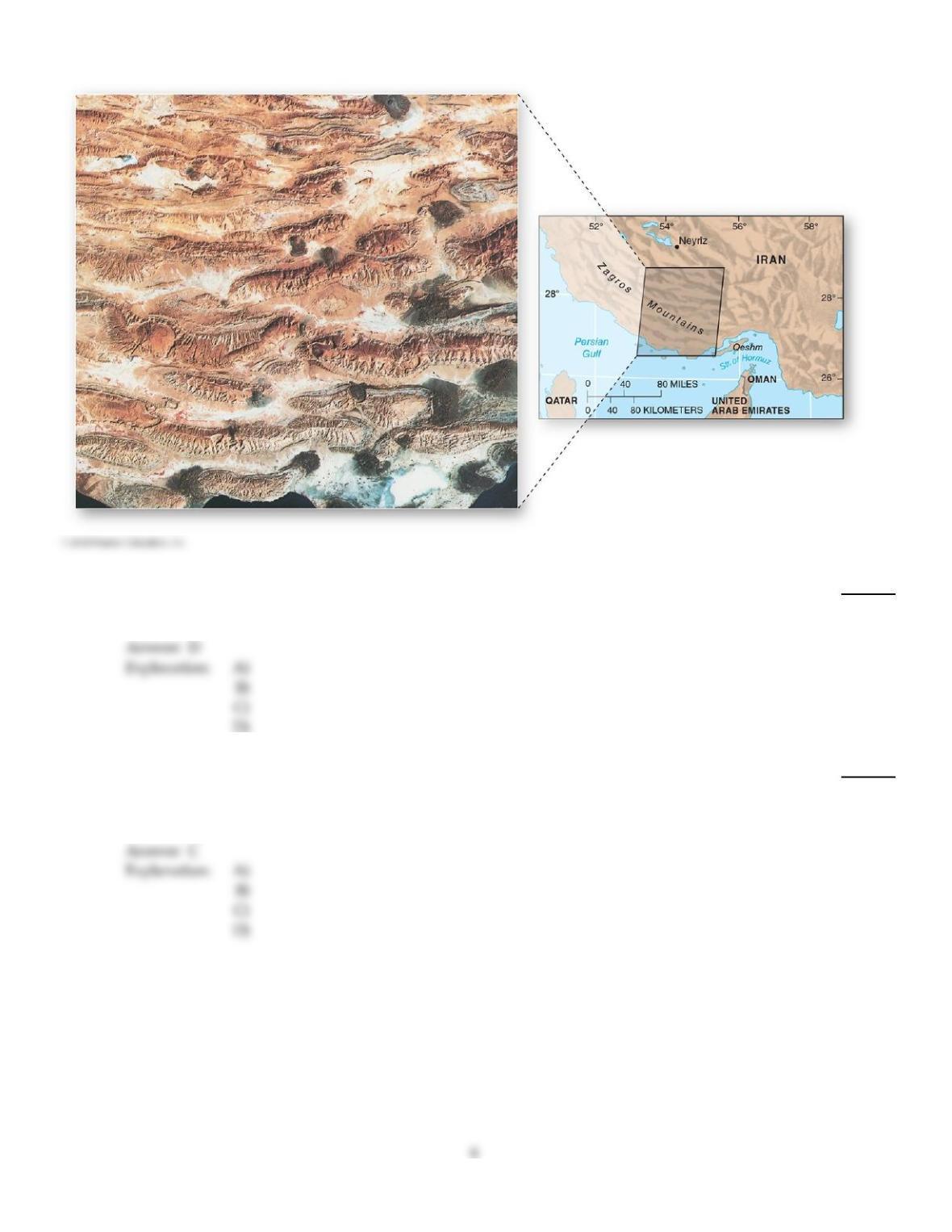
16)
The Zagros mountains of Iran is an example of
16)
A)
a zone of tension.
B)
a zone of shearing motions.
C)
a series of faulted mountain blocks.
D)
a zone of compression and folding.
17)
The Basin and Range Province in the western United States is a result of ________ faulting
produced by ________ forces.
17)
A)
normal; compressional
B)
reverse; tensional
C)
normal; tensional
D)
reverse; compressional
18)
Which of the following is NOT one of the three types of tectonic activity that causes orogenesis
along convergent boundaries?
18)
A)
Oceanic plate–oceanic plate collision
B)
Continental plate–continental plate collision
C)
Oceanic plate–continental plate collision
D)
Oceanic plate–continental plate collision, oceanic plate–oceanic plate collision, and
continental plate–continental plate collision are all correct.
19)
Volcanic activity located away from plate boundaries is associated with
19)
A)
rift zones.
B)
subduction and melting of plates along collision zones.
C)
hot spots.
D)
all of the above.
20)
________ provides the highest resolution for mapping Earth’s surface.
20)
A)
Passive remote sensing platforms, such as Landsat 8,
B)
GPS
C)
LiDAR
D)
Radar
21)
If one were to stack thick fabric on top of one another, then push the opposite ends towards one
another, resulting and bending and rumpling, this would illustrate what physical process?
21)
A)
Faulting
B)
Shear
C)
Tension
D)
Folding
22)
Folded layers of rock can form a wavelike pattern of troughs and crests. The layers near the crest
(i.e. the upward fold) form
22)
A)
an anticline.
B)
a thrust fault.
C)
a syncline.
D)
a tension zone.
23)
Which of the following is a cause of warping?
23)
A)
Hot spots
B)
Mantle convection
C)
Isostatic adjustment
D)
Mantle convection, hot spots, and isostatic adjustment all cause warping.
D
24)
The phrase “considerable–to–serious damage to buildings” would be used in the ________ scale.
24)
A)
Moh’s
B)
Beaufort
C)
Modified Mercalli Intensity
D)
Richter
C
25)
Which of the following is an example of a first order of relief?
25)
A)
The Shenandoah Valley
B)
The Tibetan Plateau
C)
North America plate
D)
The Alps and Rockies
C
26)
A ________ occurs when the fault plane forms a low angle relative to the horizontal, resulting in the
overlying block being shifted over the underlying block.
26)
A)
normal fault
B)
lateral fault
C)
thrust fault
D)
strike–slip fault
C
A
27)
A continental craton is best described as
27)
A)
the inactive remains of ancient tectonic activity.
B)
the product of active folding and faulting.
C)
the surface accumulation of molten rock.
D)
a landform undergoing constant tectonic activity.
28)
The concept of “orders of relief” refers to
28)
A)
the ordering of surface features based on height.
B)
the ordering of surface features based on their time of origin.
C)
the rate at which stress is relieved in the crust.
D)
the classification of landscapes based on scale.
29)
A gently sloping mountain landform built from effusive eruptions is known as a
29)
A)
crater.
B)
cinder cone.
C)
caldera.
D)
shield volcano.
30)
Warping produces bends in rocks that are ________ those produced by folding.
30)
A)
larger than
B)
the same size as
C)
smaller than
31)
The variety of surface features on Earth results from
31)
A)
exogenic processes only.
B)
endogenic processes only.
C)
Both endogenic and exogenic processes.
32)
Large, basin–shaped depressions that form when summit materials on a volcanic mountain
collapse inward after an eruption or loss of magma are known as
32)
A)
cinder cones.
B)
craters.
C)
calderas.
D)
domes.
33)
What type of convergent boundary associated with orogeny is illustrated here?
33)
A)
Oceanic plate–oceanic plate collision
B)
Oceanic plate–continental plate collision
C)
Continental plate–continental plate collision
34)
Circular surface depressions usually found at or near the summit of a volcano are known as
34)
A)
cinder cones.
B)
craters.
C)
calderas.
D)
domes.
35)
The subsurface area where the motion of seismic waves is initiated along the fault plane is called
the
35)
A)
fault area.
B)
focus, or hypocenter.
C)
epicenter.
D)
Richter zone.
36)
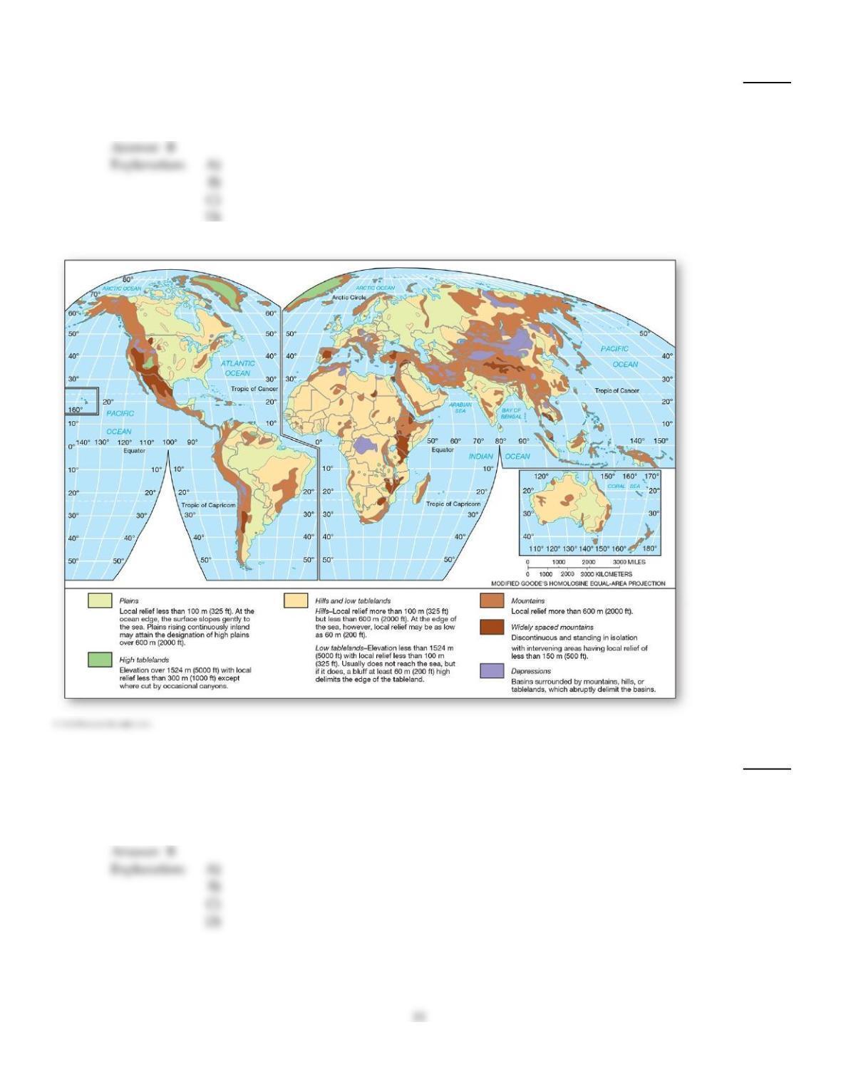
The six types of topographic regions are defined based on
36)
A)
logarithmic relationships applied to elevation.
B)
arbitrary elevation or other descriptive criteria in common use.
C)
local criteria that have never been universally recognized.
D)
complex statistical analyses of surface relief variation across the surface of Earth.
37)
A large region identifiable by several topographic or geological traits is known as a
37)
A)
physiographic province.
B)
ecoregion.
C)
biome.
D)
topographic region.
38)
Orogenesis refers to
38)
A)
the beginning of extensive faulting.
B)
the formation of mountains without faulting, folding, or the capture of migrating terranes.
C)
a general thinning of the crust.
D)
a general term for a mountain–building episode that thickens continental crust.
D
39)
Folded layers of rock can form a wavelike pattern of troughs and crests. The layers near the trough
(i.e. downward fold) form
39)
A)
an anticline.
B)
a thrust fault.
C)
a syncline.
D)
a tension zone.
C
40)
When lateral shear causes horizontal movement along a fault plane, the resulting fault is called a
40)
A)
normal fault.
B)
thrust fault.
C)
lateral fault.
D)
strike–slip fault.
D
41)
Which of the following is NOT correct regarding terranes?
41)
A)
They can move thousands of miles from their place of origin.
B)
They are framed by fracture zones.
C)
They are very similar in composition to the continents to which they attach.
D)
They are smaller–scale migrating crustal pieces; i.e., microplates.
E)
They may accrete onto continents and thereby increase the size of the continents.
C
A
42)
Which of the following is an example of a third order of relief?
42)
A)
The Alps
B)
The Tibetan Plateau
C)
Irazú Volcano
D)
The South America Plate
43)
An active volcano is defined as one that
43)
A)
exhibits activity indicative of an imminent eruption.
B)
has erupted at least once within recorded history
C)
has erupted at least once within the past century.
D)
has erupted at least once within the past decade.
44)
Effusive eruptions are NOT related to which of the following?
44)
A)
Magma with a 50–75 percent silica content, high in aluminum
B)
Magma rich in iron and magnesium
C)
Low–viscosity magma
D)
The volcanic activity in Hawaii
45)
Vertical elevation differences in a local landscape are referred to as
45)
A)
an order of relief.
B)
crust.
C)
relief.
D)
topography.
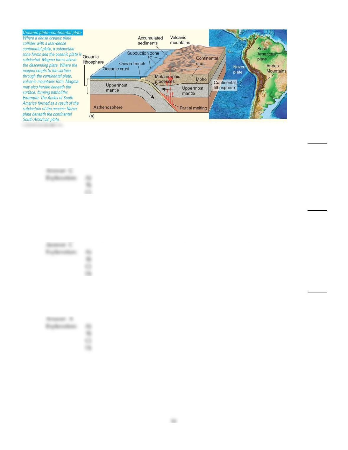
46)
What type of convergent boundary associated with orogeny is illustrated here?
46)
A)
Continental plate–continental plate collision
B)
Oceanic plate–oceanic plate collision
C)
Oceanic plate–continental plate collision
47)
Which of the following shows the general sequency of an orogeny?
47)
A)
Weathering and/or erosionupliftthickening of crust through accretion or magma intrusion
B)
Thickening of crust through accretion or magma intrusionweathering and/or erosionuplift
C)
Thickening of crust through accretion or magma intrusionupliftweathering and/or erosion
D)
Upliftthickening of crust through accretion or magma intrusionweathering and/or erosion
C
48)
The study of plate boundaries and the frequency of past earthquakes in order to forecast
earthquakes is known as
48)
A)
paleoseismology.
B)
perceptual studies.
C)
geodesy.
D)
dilatancy.
A
C
49)
Explosive eruptions tend to build up
49)
A)
many subsequent lava flows.
B)
plateau basalts.
C)
composite volcanoes.
D)
shield–shaped volcanoes.
50)
The general term that describes subducted oceanic crusts that incorporate seawater and sediments
is
50)
A)
batholiths.
B)
sima.
C)
melt.
D)
sial.
51)
The measurement of land elevation relative to sea level is known as
51)
A)
hypsometry.
B)
topography.
C)
geodesy.
D)
bathymetry.
52)
Strain, the amount of deformation undergone by an object, is expressed in rocks by
52)
A)
metamorphism.
B)
breaking and removal.
C)
bending.
D)
folding or faulting.
53)
A hypsographic curve is
53)
A)
a graph that shows the change in temperature with depth below the surface of a continent.
B)
a graph that shows the change in temperature with depth below the surface of the ocean floor.
C)
a graph that shows Earth is of relatively high relief.
D)
a graph that shows Earth’s relief is great when compared to its diameter.
E)
a generalized curve showing Earth’s surface by area and elevation in relation to sea level.
54)
The San Andreas system in California is an example of a
54)
A)
thrust fault.
B)
strike–slip fault.
C)
transform fault.
D)
both a strike–slip and transform fault.
55)
Which of the following is CORRECT regarding the moment magnitude scale?
55)
A)
It is a closed scale that begins at 0.0 and ends at 10.0.
B)
It is a scale of magnitude based on arithmetical progressions (1,2,3,4, etc.).
C)
It considers the amount of fault slippage produced by the earthquake, the size of the surface
(and subsurface) area that ruptured, and the nature of the materials that faulted.
D)
It is the same as the Mercalli scale.
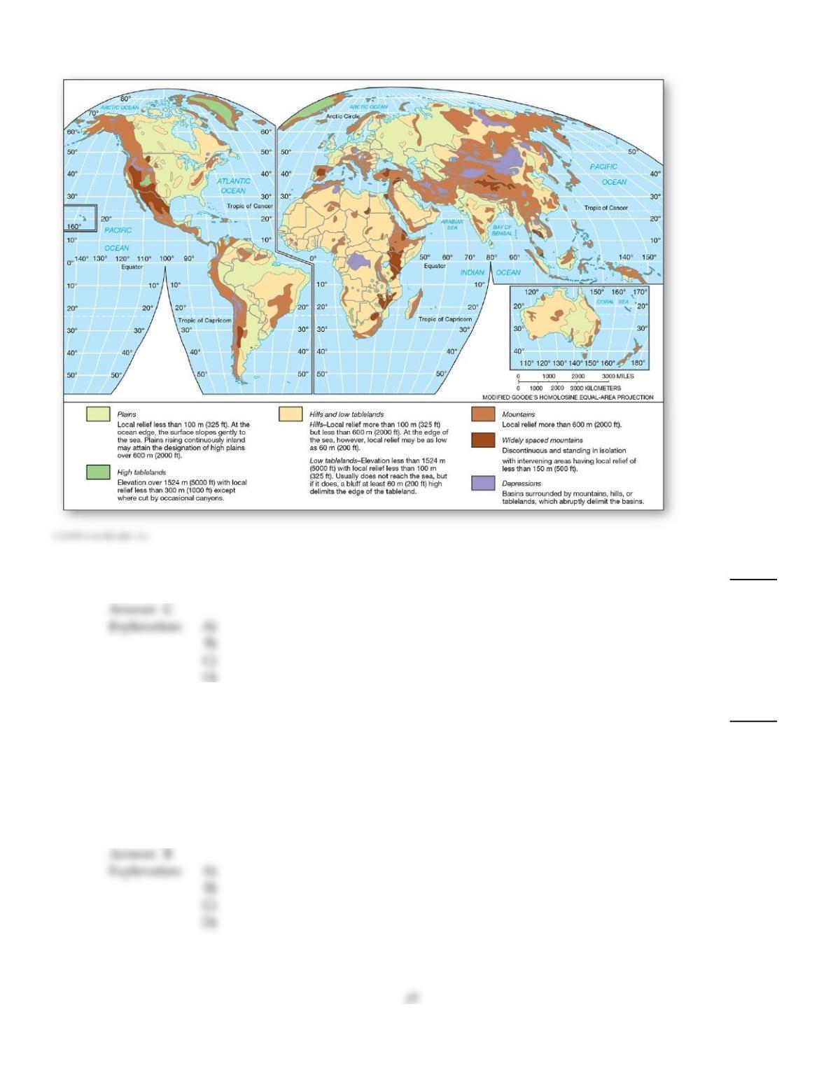
56)
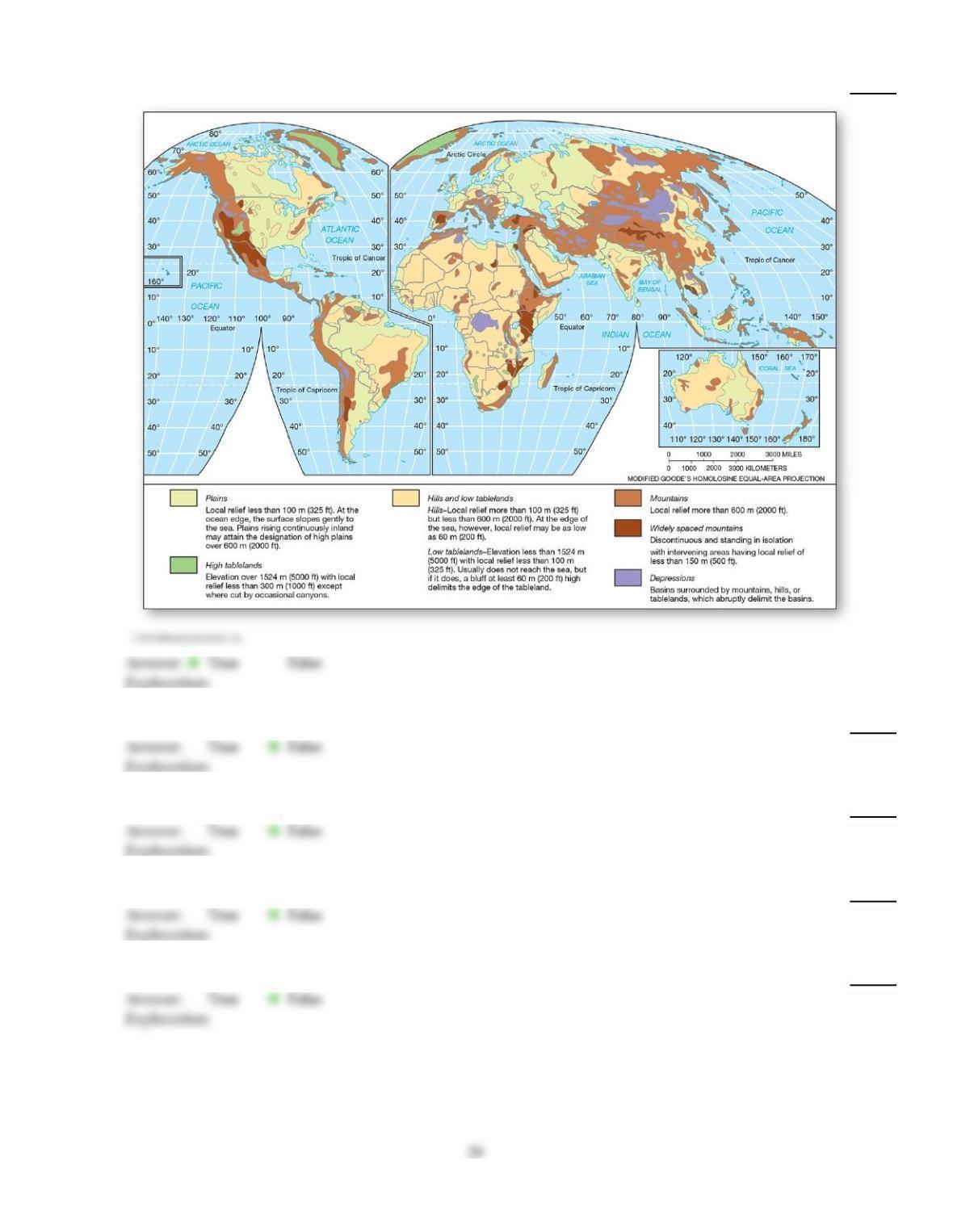
A topographic region that is characterized by local relief of more than 600 m (2,000 ft) is a
56)
A)
depression.
B)
low tableland.
C)
mountain
D)
high tableland.
57)
Which of the following most accurately describes the current status of volcano forecasting?
57)
A)
The eruption of Mount Pinatubo was the impetus for the Volcano Disaster Assistance
Program (VDAP).
B)
Integrated seismographic networks and monitoring play an important role in early warning
systems for volcanic activity.
C)
Scientists have hypothesized that early warning systems are possible, but none have been
developed yet.
D)
Forecasting volcanoes is not possible given the abrupt nature of explosions.
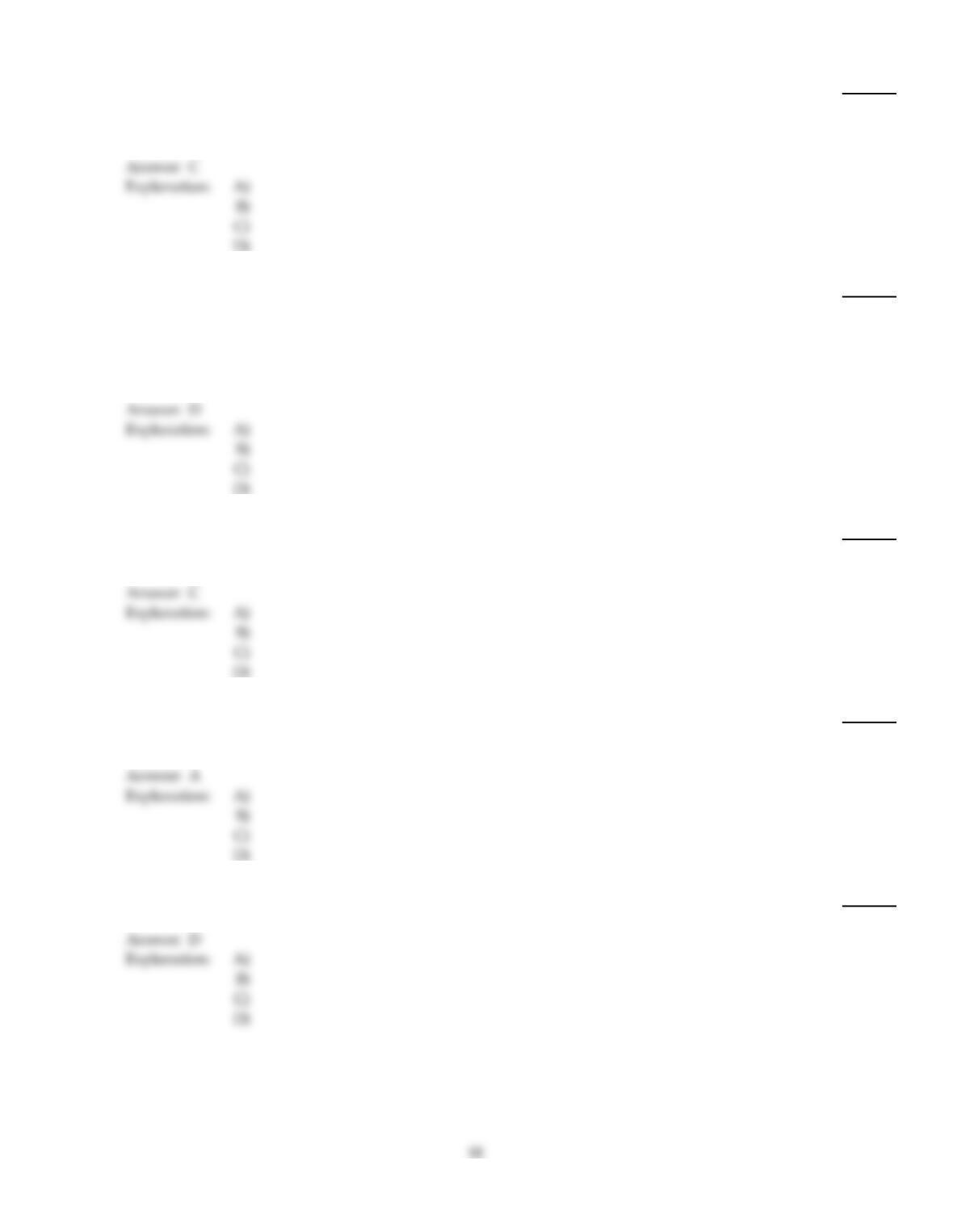
58)
The relatively young mountains along the western margins of the North America and South
America plates are referred to as the
58)
A)
Eurasian–Himalayan system.
B)
Sierra Nevadan orogeny.
C)
Cordilleran system.
D)
Allegheny orogeny.
59)
An effusive eruption ________, whereas an explosive eruption ________.
59)
A)
produces composite volcanoes; is an outpouring of low–viscosity magma onto the ground
B)
is a violent explosion of magma, gas, and pyroclastics; produces shield volcanoes
C)
produces composite volcanoes; produces shield volcanoes
D)
is an outpouring of low–viscosity magma onto the ground; is a violent explosion of magma,
gas, and pyroclastics
60)
The Appalachians formed as a result of the
60)
A)
Cordilleran orogeny.
B)
Laramide orogeny.
C)
Allegheny orogeny.
D)
Alpine orogeny.
61)
The general term for the undulations and other variations in the shape of Earth’s surface is called
61)
A)
topography.
B)
relief.
C)
terrain.
D)
geomorphology.
62)
Molten rock that pours forth on Earth’s surface is called
62)
A)
intrusive.
B)
metamorphic.
C)
magma.
D)
lava.
63)
What is the expected number of an M 5–5.9 or Mercalli V–VII earthquakes per year?
63)
A)
134
B)
1
C)
1319
D)
13,000
64)
Which of the following properly describes the formation of continental crust?
64)
A)
All continental crust was formed millions of years ago. There is no active continental crust
being formed.
B)
New continental crust is formed essentially in the same many as oceanic crustfrom
upwelling at mid–continental ridges.
C)
The formation of continental crust involves the entire sequence of seafloor spreading,
subduction, remelting of oceanic crust, and subsequent rise of the remelted material.
D)
The formation of continental crust is independent of the formation of oceanic crust, involving
only volcanism over the land masses.
65)
When rock strata are strained beyond their ability to remain an intact unit, displacement occurs in a
process known as
65)
A)
faulting.
B)
folding.
C)
stressing.
D)
broad warping.
66)
A seismic gap refers to an area that
66)
A)
is overdue for an earthquake, based on past earthquake frequency.
B)
has had tectonic plates separate, leaving large cracks in the surface.
C)
has significant surface fracturing due to fault movement.
D)
is lacking seismometers or other measuring devices.
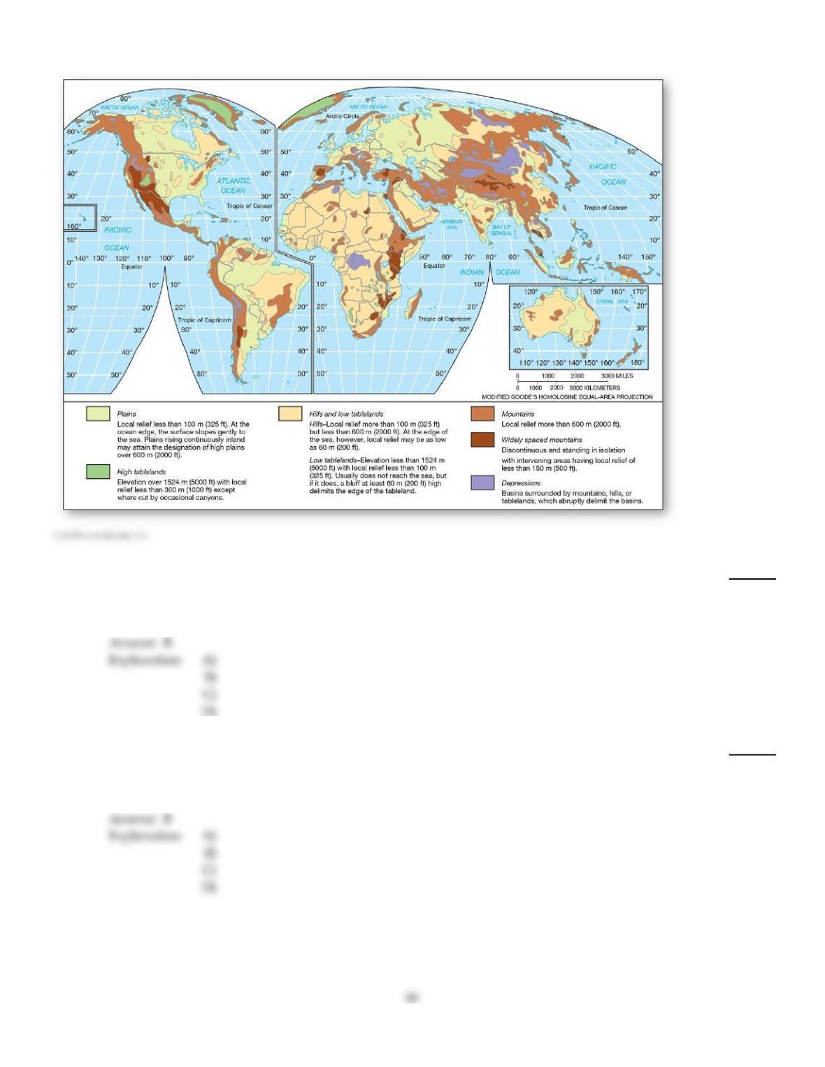
67)
A topographic region that is characterized by local relief of more than 100 m (325 ft.), but less than
600 m (2000 ft.), is considered a
67)
A)
mountain.
B)
hill or low tableland.
C)
plain.
D)
high tableland.
68)
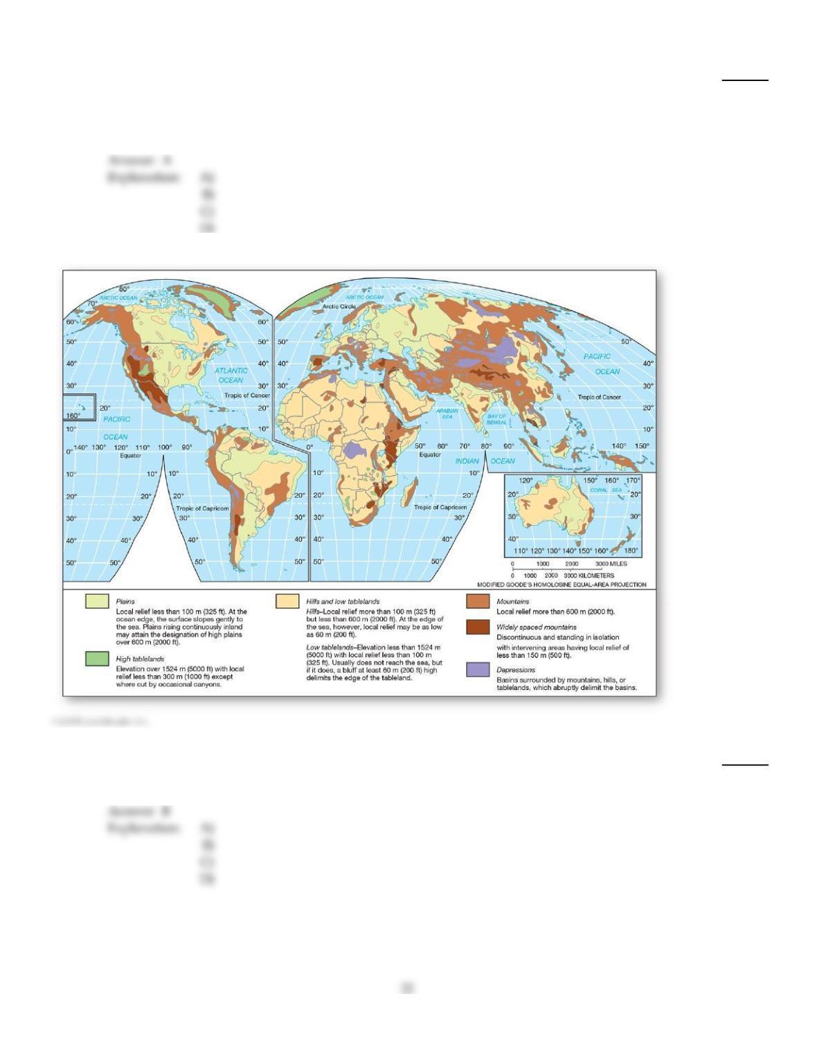
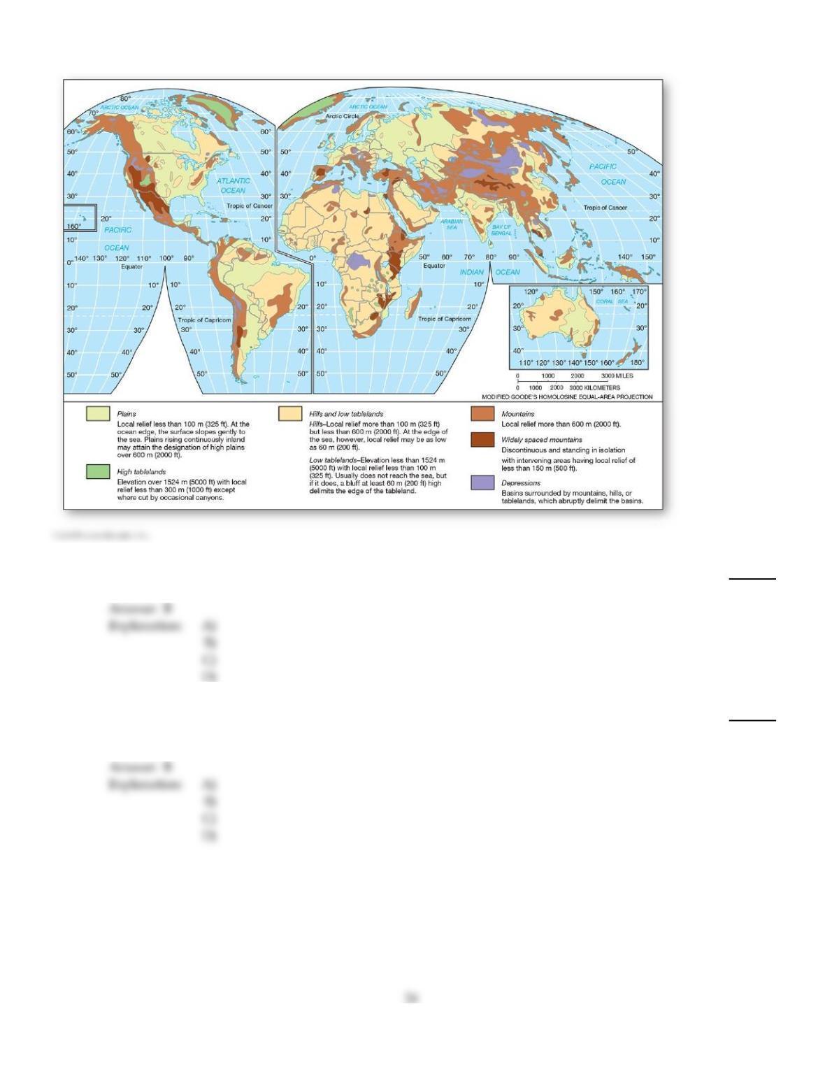
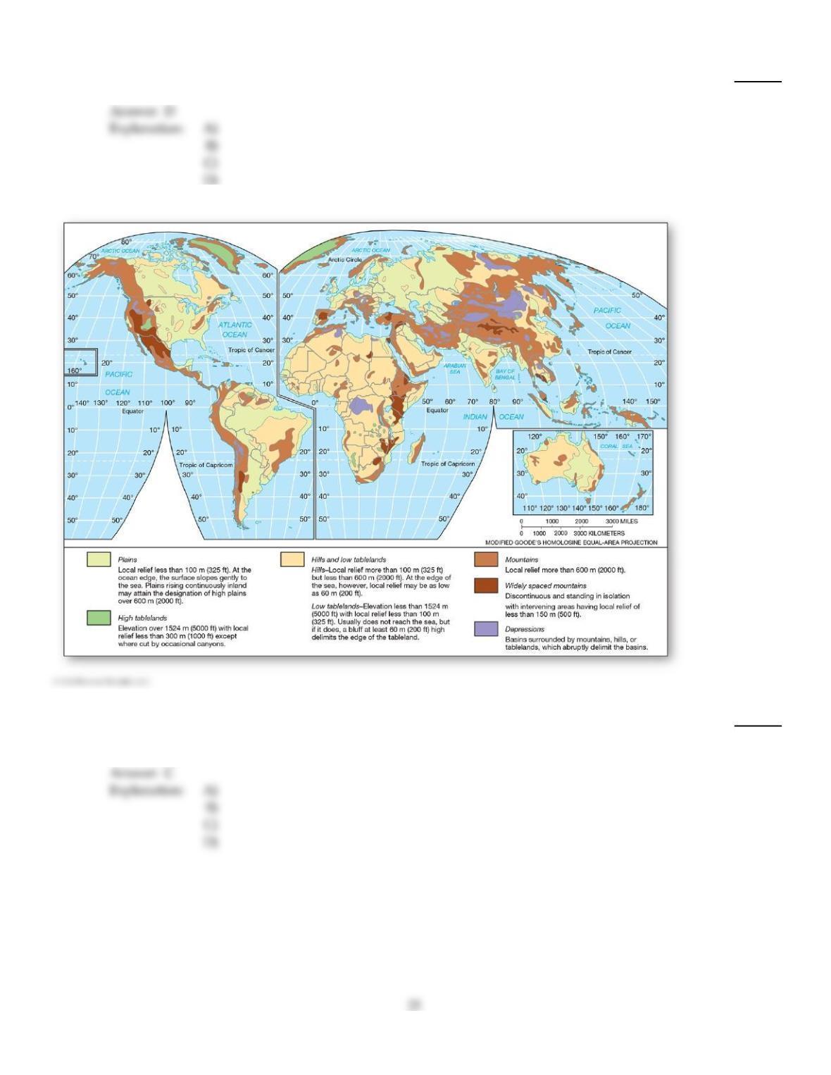
Large portions of North and South America, Asia, and Australia are dominated by which
topographic region?
68)
A)
Widely space mountains
B)
Plains
C)
High tablelands
D)
Basins
69)
An earthquake that occurs in association with anthropogenic activity, such as waste water injection
wells, is known as
69)
A)
a tectonic earthquake.
B)
tectonic seismicity.
C)
induced seismicity.
D)
an earthquake. (There is no special name for such an implausible event.)
70)
Small surface irregularities along a fault plane that prevent movement and are generally areas of
high strain are termed
70)
A)
asperities.
B)
fore points.
C)
elastic spots.
D)
focal points.
71)
The slight increase in rock volume produced by small cracks that form under stress and
accumulated strain is known as
71)
A)
dilatancy.
B)
seismic gaps.
C)
geodesy.
D)
paleoseismology.
72)
Which of the following is an example of the tools scientists use to study topography?
72)
A)
Radar
B)
LiDAR
C)
GPS
D)
LiDAR, radar, and GPS are all used in the study of topography.
73)
Fault types are differentiated by
73)
A)
the tilt and orientation of the fault plane.
B)
the type of rock material in which they occur.
C)
the amount of movement along the fault plane.
D)
the amount of energy liberated during movement.
74)
A topographic region that is characterized by local relief of less than 100 m (325 ft.) is considered a
74)
A)
depression.
B)
plain.
C)
high tableland.
D)
hill or low tableland.
75)
Tensional stress along a fault can result in a dropped hanging–wall block relative to the footwall
side, producing a
75)
A)
thrust fault.
B)
strike–slip fault.
C)
reverse fault.
D)
normal fault.
76)
What is the expected number of an M 8.0 or Mercalli XII earthquakes per year?
76)
A)
120
B)
13,000
C)
800
D)
1
77)
Which of the following is INCORRECTLY matched?
77)
A)
Compression shortening or folding
B)
Tension stretching or faulting
C)
Shearing stretching or faulting
D)
Tension normal fault
78)
Most cratons date to the
78)
A)
Paleozoic era.
B)
Precambrian eon.
C)
Devonian period.
D)
Paleocene epoch.
79)
Terranes refer to
79)
A)
subducted oceanic crust that is melted and later reaches the surface in volcanic eruptions or
cools in the subsurface as an intrusive body.
B)
fragmented crustal material from one plate and accreted to another plate.
C)
a large region where a craton is exposed at the surface.
D)
the topography of a tract of land.
80)
Large areas of depressions are found in
80)
A)
Antarctica.
B)
Asia.
C)
Australia.
D)
North America.
81)
The nucleus of old crystalline rock in each of the principal continental masses is called a
81)
A)
composite zone.
B)
continental shield, or craton.
C)
mountain mass.
D)
basalt mass.
82)
An exposed fault plane with significant vertical extent is known as
82)
A)
dome.
B)
anticline.
C)
a fracture zone.
D)
an escarpment.
83)
Africa is dominated by which topographic region?
83)
A)
High tablelands
B)
Mountains
C)
Hills and low tablelands
D)
Plains
84)
Large areas of high tablelands are found in
84)
A)
Central Asia.
B)
Greenland.
C)
Australia.
D)
Africa.
85)
Small conical–shaped hills with truncated tops that formed during moderately explosive volcanic
eruptions are known as
85)
A)
cinder cones.
B)
craters.
C)
calderas.
D)
domes.
86)
The vertical relief of Earth (highest point to lowest point) is approximately
86)
A)
5 km (3.1 mi).
B)
10 km (6.2 mi).
C)
20 km (12.4 mi).
D)
30 km (18.6 mi).
87)
Pulverized rock and clastic materials ejected violently during an eruption are called
87)
A)
explosive debris.
B)
tephra, or pyroclastics.
C)
cinders.
D)
volcanic ash.
88)
An instrument used to record vibrations in the crust is the
88)
A)
tiltmeter.
B)
the Richter scale.
C)
seismometer.
D)
land barometer.
C
89)
The area at the surface directly above the subsurface location where seismic waves are initiated is
termed the
89)
A)
fault area.
B)
Richter zone.
C)
focus, or hypocenter.
D)
epicenter.
D
90)
Which of the following is an example of a second order of relief?
90)
A)
Mt. Capulin
B)
Pike’s Peak
C)
The North America plate
D)
The Canadian and American Rockies
D
TRUE/FALSE. Write ‘T’ if the statement is true and ‘F’ if the statement is false.
91)
Modern technologies, such as GPS, LiDAR, and radar are important tools for studying Earth’s
topography.
91)
92)
The San Andreas fault is principally the result of compressional stress.
92)
B
93)
Radon gas emissions and changes in the magnetic field are some of the phenomena that often occur
prior to a quake.
93)
94)
Scientists have been able to accurately forecast earthquakes for approximately a decade.
94)
95)
Oceanic trenches form when one oceanic plate collides with another oceanic plate.
95)
96)
The elastic–rebound theory explains what happens to Earth’s plates during an earthquake.
96)
97)
The Basin and Range Province of the interior western United States is a type of horst–and–graben
topography.
97)
98)
The first order of relief is the most detailed order and includes mountains, cliffs, valleys, hills, and
other landforms.
98)
99)
Earth’s landscapes are generalized to 12 topographic regions, each defined based on specific,
statistical criteria.
99)
100)
A tall, conically–shaped volcanic peak is generally the result of effusive eruptions.
100)
101)
Amplitude is the height of a seismic wave and is directly related to the amount of ground
movement.
101)
102)
Whereas mountains occur on every continent, depressions (basins) only occur in Asia and Africa.
102)
103)
In an oceanic plate–continental plate collision, denser continental crust dives beneath oceanic crust.
103)
104)
A seismic gap refers to ruptures in the land surface that result from an earthquake.
104)
105)
A normal fault is associated with compressional stress.
105)
106)
Oil and natural gas tend to concentrate in the low areas of a fold; i.e., near the bottom of a syncline.
106)
107)
Landscapes are grouped into orders of relief by scale, from continents and ocean basins to
individual landforms.
107)
108)
Shortening or folding of the crust is produced by strain caused by tension.
108)
109)
An orogeny is usually caused by large–scale deformation and uplift of crust.
109)
110)
Cratons are generally of low elevation and old in age.
110)
111)
Terranes refer to the topography of a tract of land.
111)
112)
History seems to teach us that humans are generally unable or unwilling to perceive hazards in a
familiar environment.
112)
113)
A reassessment of pre–1993 earthquakes using the moment magnitude scale has increased the
rating of all earthquakes based on the Richter scale.
113)
114)
The Hawaiian Islands are near one end of a hot–spot track that stretches to the Aleutian Islands.
114)
115)
Compressional forces associated with converging plates produce blocks that move upward relative
to the footwall block; this is called a thrust or reverse fault.
115)
116)
Tension creates stretching and results in thinning crust.
116)
117)
The Appalachian Mountains are older than the Rocky Mountains.
117)
118)
Explosive eruptions produce composite volcanic peaks.
118)
119)
The relief from Earth’s highest point to its lowest point is approximately 50 km (31 mi).
119)
120)
The Alps is an example of the second order of relief.
120)
121)
An earthquake with a high rating on the moment magnitude scale can receive a low rating on the
Mercalli scale.
121)
122)
A thrust fault is associated with compressional stress.
122)
123)
An active volcano is one that has erupted at least once in the last 25 years.
123)
124)
Earthquakes associated with human activity, such as waste water injection wells, are known as
induced seismicity.
124)
125)
Geologically speaking, the continents began forming relatively recently.
125)
126)
Crater Lake in southern Oregon is an example of a caldera.
126)
127)
The Richter scale replaced the moment magnitude (M) scale for measuring earthquake magnitude.
127)
128)
In a reverse fault, the hanging wall moves upward relative to the footwall.
128)
129)
The Sierra Nevada and Grand Tetons are examples of tilted–fault–block mountain systems.
129)
130)
Terranes often differ in rock composition and structure from the continental plate to which they
accreted.
130)
131)
Individual mountains, cliffs, valleys, hills, and other landforms are examples of third order of relief.
131)
132)
A playa is a dry lakebed characterized by an area of salt crust left behind by evaporation of water.
132)
133)
Paleoseismology estimates expected earthquake activity based on past earthquake activity.
133)
134)
In a normal fault, the hanging wall drops (moves downward) relative to the footwall.
134)
135)
The average elevation of all Earth’s surface is slightly above sea level at this time in Earth’s history.
135)
136)
A continental shield is a large region where a craton is exposed at the surface.
136)
137)
Orogens are remarkably well correlated with the plate tectonics model.
137)
138)
The magnitude of some aftershocks rival that of the main earthquake.
138)
139)
The measurement of land elevations relative to sea level is known as hypsometry.
139)
140)
Extensive plains are found in North and South America, Asia, and Australia.
140)
141)
Human populations are growing in areas prone to seismic activity and near active volcanoes.
141)
142)
Orogenesis may begin with the capture of migrating terranes.
142)
143)
Folding occurs when rocks are deformed as a result of compressional stress and shortening.
143)
144)
Prior to the invention of seismometers, damage to terrain and structures and severity of shaking
were used to assess an earthquakes size.
144)
145)
The topography of Earth’s surface has had relatively little influence on human activities and
culture.
145)
ESSAY. Write your answer in the space provided or on a separate sheet of paper.
146)
Compare and contrast explosive and effusive eruptions. Include their locations, the chemical composition of the
magma, and the landforms they typically produce.
147)
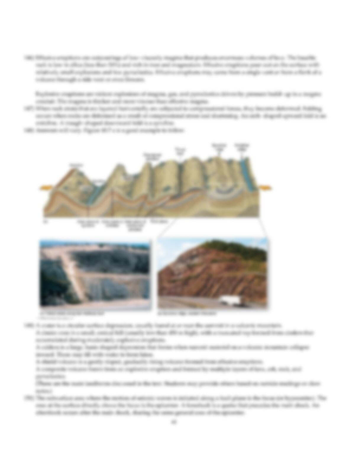
Discuss the process and causes of folding and distinguish between anticline and syncline.
148)
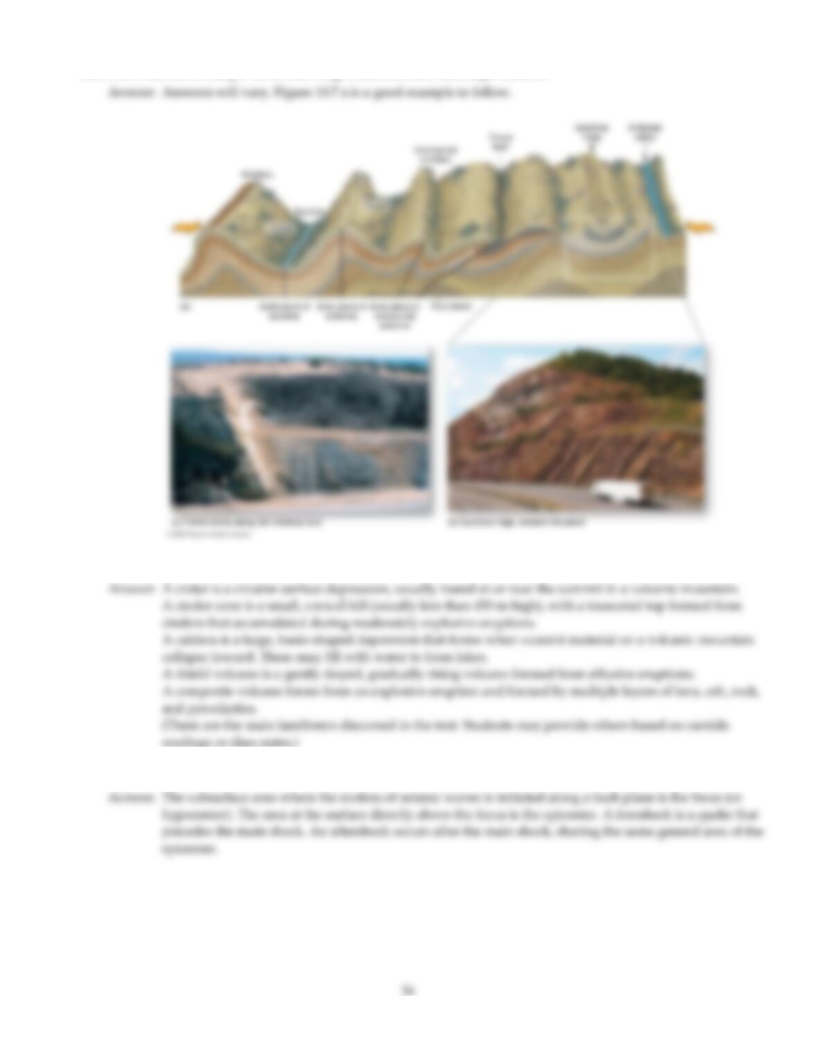
Draw and label a simple sketch showing common folded landscape features.
149)
Describe various volcanic landforms.
150)
Define and distinguish between the following: epicenter, focus, foreshock, aftershock.
151)
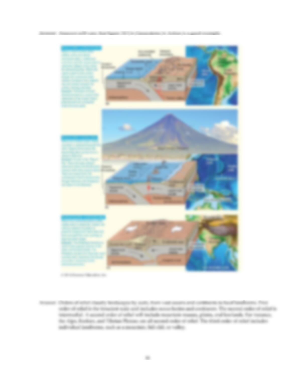
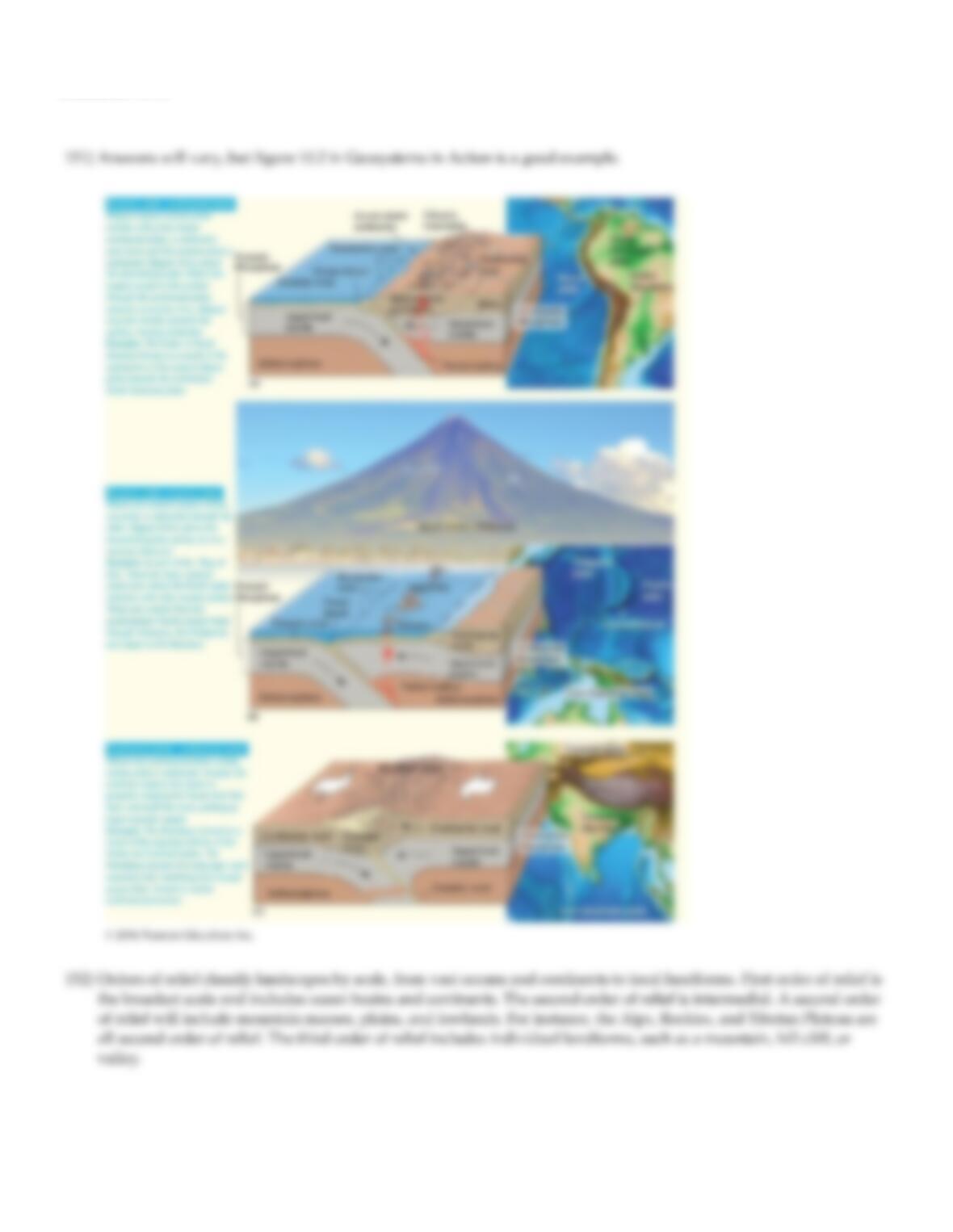
Draw and label a diagram of the three types of convergent plate boundaries and their typical orogenies.
152)
Describe the three orders of relief and give one example of each.
153)
Describe the creative forces and typical characteristics of the three major types of faults.
154)
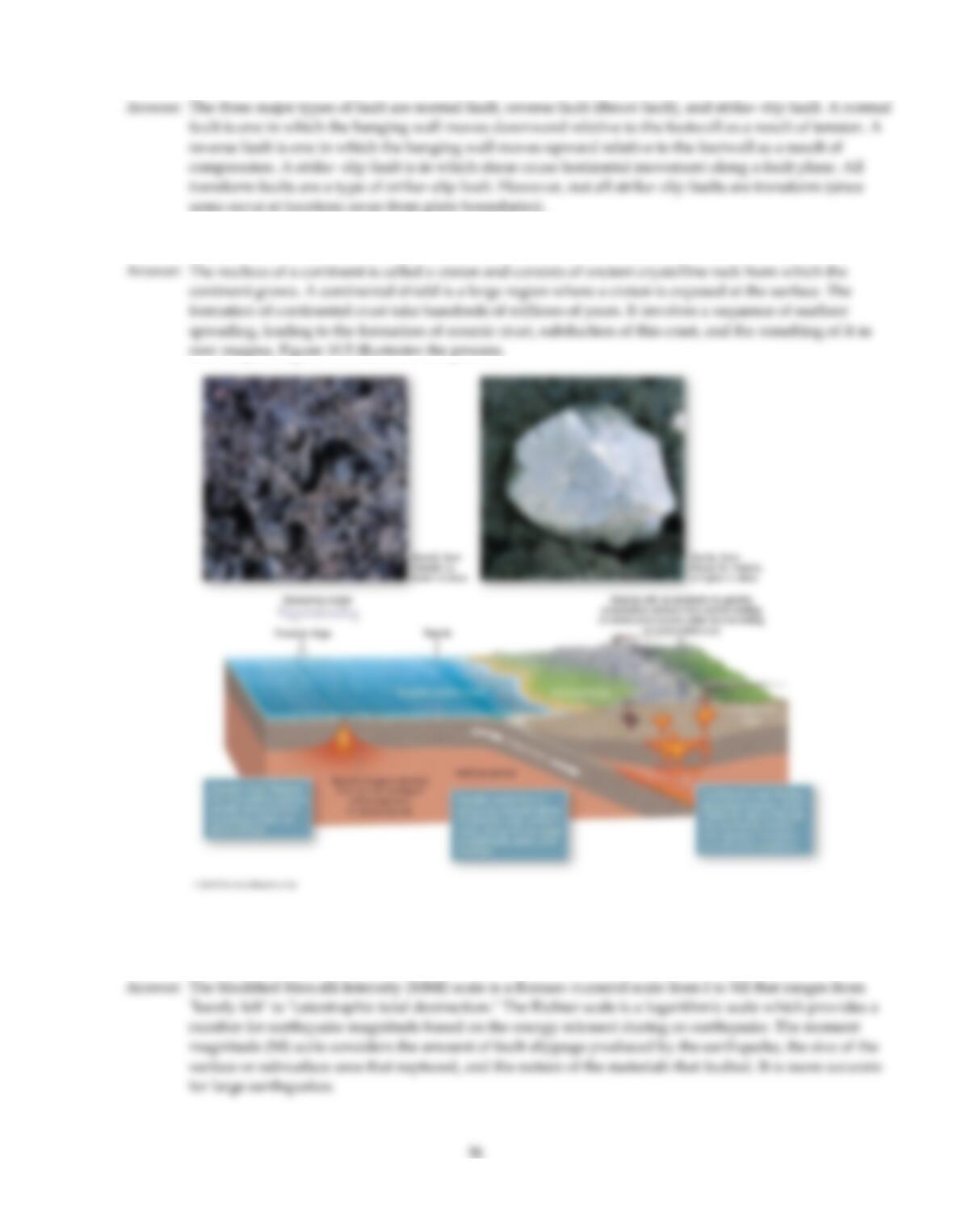
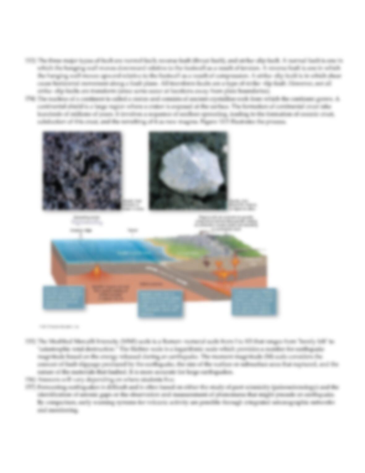
Describe the typical formation and characteristics of a continental shield.
155)
What are the different ways of measuring the intensity and/or effects of earthquakes? Which do you think is
best, and why?
156)
Discuss the seismic hazards in your area. Are these tectonically driven or induced seismicity?
157)
Discuss why short term predictions of earthquakes are not yet entirely reliable, while volcanoes are more easily
predicted.
158)
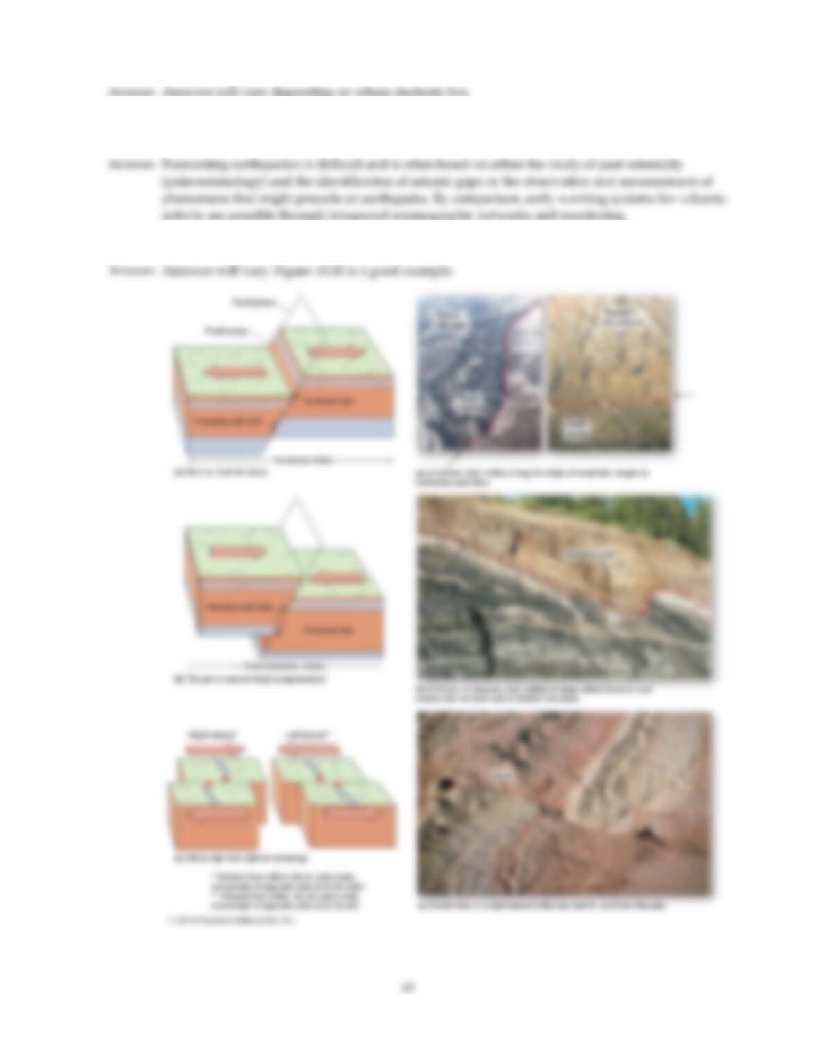
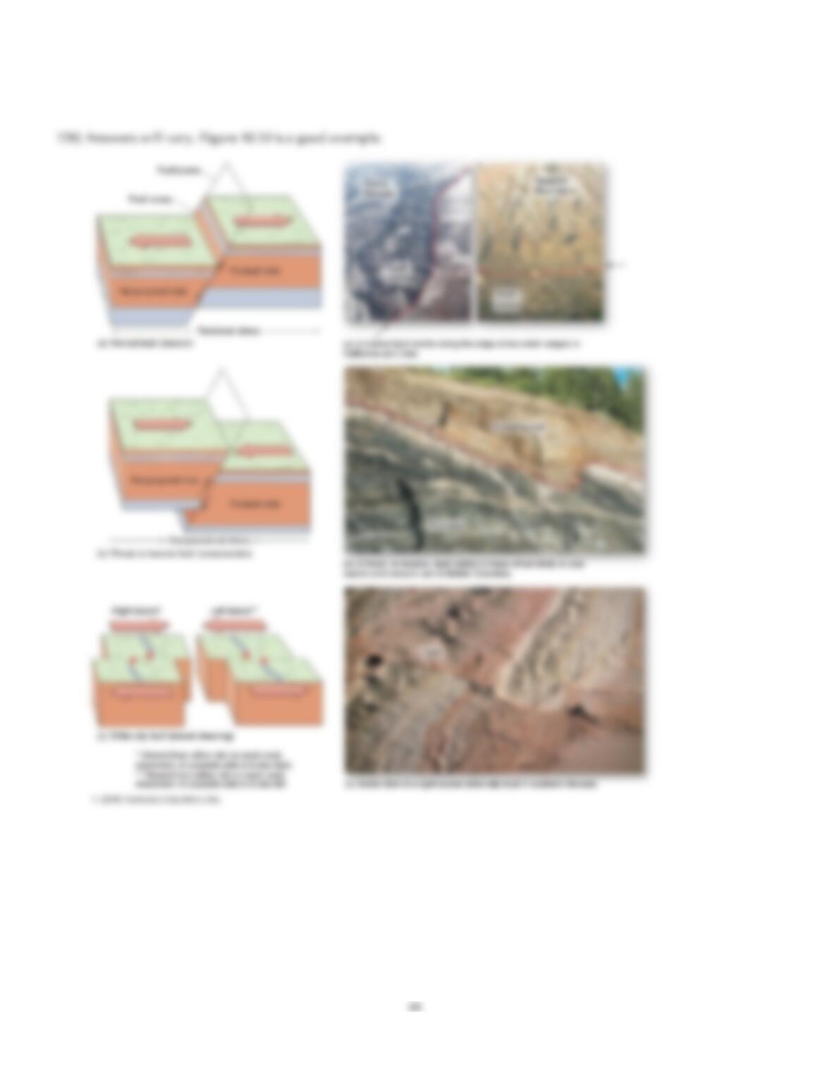
Draw and label a simple sketch showing the three major types of faults.
Answer Key
Testname: C10
Answer Key
Testname: C10
Answer Key
Testname: C10
40
Answer Key
Testname: C10
Answer Key
Testname: C10
42
Answer Key
Testname: C10
43
Answer Key
Testname: C10