
52) Common practices of ________ include exploiting the distinctive economic assets of
different countries and regions, organizing production according to a spatial division of labor,
placing earnings in offshore bank accounts to avoid paying taxes, and moving factories from
high wage regions to low wage regions.
A) transnational corporations
B) nonessential employees
C) democratic governments
D) nationalized corporations
E) locally owned corporations
53) The township and range system
A) established a gridlike pattern for much of present-day land use in the United States.
B) is in use nearly everywhere in the world.
C) was used for navigation by early pioneers, traders, and explorers in North America.
D) established a gridlike pattern for much of present-day Europe and the United States.
E) was used throughout Europe until the mid-1800s, after which the United States adopted it.
54) The U.S. Land Ordinance of 1785 divided much of the country into a system of
A) townships, towns, cities, municipalities, and major urban centers.
B) ranges, distances, scales, projections, and map symbols.
C) town-county boundaries.
D) quarter sections, range sections, town land sections, and county sections.
E) townships, ranges, sections, and quarter sections.
55) The arrangement of a phenomenon across Earth’s surface is
A) dispersal.
B) spatial analysis.
C) spatial association.
D) distribution.
E) regional dissociation.
56) The frequency of something within a given unit of area is
A) concentration.
B) density.
C) distribution.
D) pattern.
E) dispersion.
57) A ________ is the spread of something over a given study area.
A) concentration
B) density
C) distribution
D) pattern
E) diffusion
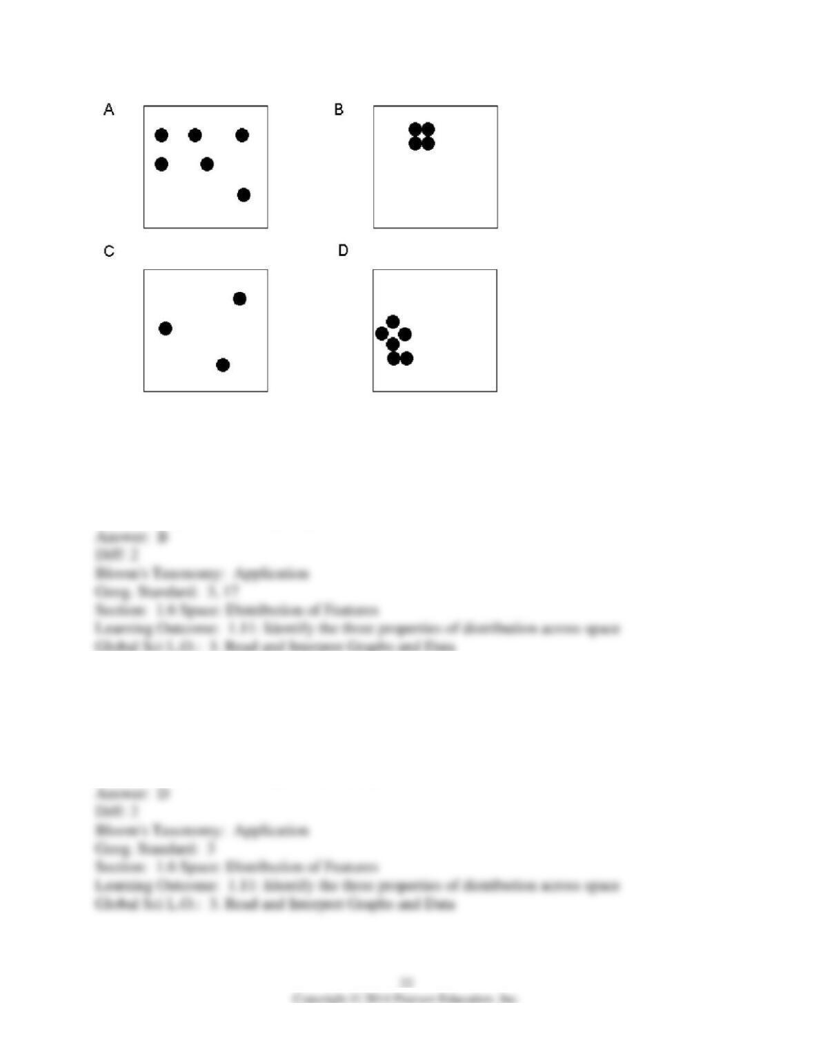
58) In this figure, which two boxes have the highest concentration of dots?
A) A, C
B) B, D
C) A, B
D) C, D
E) All of these boxes have the same concentration of dots.
59) In this figure, which two of the four boxes have the highest density of dots?
A) A, B
B) B, C
C) C, D
D) A, D
E) all of these boxes have equivalent density
60) A hearth is
A) a region from which a phenomenon originates.
B) the process by which a feature or trend spreads.
C) an area defined by one or more distinctive features or trends.
D) the modification of a culture as a result of contact with a more powerful one.
E) the perimeter or boundary marked by a regional feature.
61) Which of the following are forms of expansion diffusion?
A) contagious and eponymous
B) hierarchical and formal
C) economic and relocation
D) contagious and hierarchical
E) relocation and stimulus
62) The historic diffusion of HIV/AIDS in the United States is an example of which type of
diffusion?
A) contagious
B) hierarchical
C) relocation
D) stimulus
E) geospatial
63) The diffusion of HIV/AIDS prevention methods and treatments in the United States is an
example of which type of diffusion?
A) contagious
B) hierarchical
C) relocation
D) stimulus
E) geospatial
64) The concept that the physical environment sets broad limits on human actions, but that
people have the ability to adjust to a wide variety of physical environments is
A) climate.
B) environmental determinism.
C) possibilism.
D) spatial association.
E) cultural relativism.
65) The study of how humans and the environment interact is called
A) environmental determinism.
B) cultural ecology.
C) cultural diffusion.
D) cultural possibilism.
E) natural science.
66) Hurricane Katrina’s landfall on the United States is an interesting geographic case study
because
A) its effects are an intersection of human and physical geography.
B) its winds reached incredible speeds near the eye of the hurricane.
C) the damage was largely a result of flooding from rivers and a storm surge, not the winds.
D) the federal government was poorly prepared for the storm and its aftermath.
E) people of all ethnic and racial groups were equally devastated by the storm.
67) According to environmental determinism,
A) the physical environment causes different types of social and cultural development.
B) the physical environment sets loose limits on cultural and social actions.
C) people cannot adjust to different physical environments because of cultural traditions.
D) people can choose a course of action from many alternatives offered by the physical
environment, and they can also engage in cultural behaviors that seem contradictory to the
environment.
E) people determine their physical environment.
68) Parallels converge at the North and South Poles.
69) The numbering system used to indicate the location of meridians is called latitude.
70) For each 15° change in longitude, time changes by one hour.
71) Every map projection distorts the surface of Earth in some way.
72) A map displays in full detail what lies on Earth’s surface.
73) If you flew south along the International Date Line you would reach the South Pole, and if
you continued flying straight ahead (with unlimited fuel) you would eventually cross the equator
along the prime meridian.
74) Formal regions cannot overlap.
75) Regions are found only where physical and economic characteristics are strongly related.
76) A functional region can exhibit the distance-decay phenomenon.
77) The communication revolution that promotes globalization of culture also permits
preservation of cultural diversity.
78) Globalization of the economy has led to more specialization at the local level.
79) Distribution refers to the arrangement of observable phenomena across a surface.
80) A high degree of dispersion within an area indicates high density.
81) The frequency of a phenomenon in a given study area is known as density.
82) The spread of an idea through the movement of people is known as stimulus diffusion.
83) Geography is concerned with the study of physical processes, although some geographic
studies do not focus primarily on physical processes.
84) A new piece of land created by draining the area is called a polder.
85) Geographers generally reject environmental determinism for possibilism.
86) The idea that the physical environment limits human actions but that people have the ability
to adjust to or act counter to that environment is called possibilism.
87) Written scale and ratio or fraction scale are two ways to express map scale. What is the third
way to indicate scale?
88) Geographers draw two types of lines (arcs) on maps to indicate location. The lines (or arcs)
drawn between the North and South Poles are known as ________. The Equator and other circles
north and south of it are known as ________.
89) List the four ways to indicate location.
90) Oxford, Ohio, is located five miles east of the Indiana state line and thirty-five miles
northwest of Cincinnati. This is an example of which of the four ways of indicating location?
91) What are the three kinds of regions that geographers identify?
92) The signal area of radio station WOXY is an example of which kind of region?
93) The area where people have heard of the rising reputation of radio station WOXY is an
example of which kind of region?
94) What force or trend is in opposition to the force of globalization?
95) The frequency of a phenomenon over a given study area is defined as ________.
96) If someone said that people living in the desert are lazy because of the intense heat, this
would be an example of what geographic approach?
97) If someone said that human activities may be limited by intense heat, but that humans have
adapted to living in the desert through the use of air conditioning, this would be an example of
what geographic approach?
98) It has been said that “all maps lie” and that most maps include political biases. What types of
biases or distortions might you suspect or imagine while looking at the maps in this chapter?
What other ways might map boundaries, place names, or symbols have been used to either
reduce biases or show other types of biases?
99) If a cartographer approached you claiming that she had produced the world’s most accurate
and useful world map, with none of the shortcomings of previous maps, why would you need to
doubt her claims? Give details or examples from this chapter to support your ideas.
100) If, on a piece of scrap paper, you drew a quick map of your hometown, state, or native
country, what kinds of mental connections or “invisible” information would this map reveal
about you? What does your sketch map reveal about your biases, your knowledge of the larger
world, and your attention to some types of details rather than others (for example, place names
versus landmarks). Do you tend to organize your thoughts and memories in terms of maps,
illustrations, words, songs, or in some other manner?
101) List each type of region described in the textbook and give an example of each.
102) Name and discuss various (and perhaps overlapping) “regions” that your community or
school is located within. Why does it pertain to each? What types of regions are these, according
to the types discussed in this chapter?
103) Think of a recent armed conflict or war discussed in the news. How do geographic concepts
help you to better understand the issues surrounding that conflict, within its specific regional
setting?
104) Discuss the ethical or moral implications of dedicating geographical research to the
diffusion of a large corporation such as McDonald’s. If you could design such a research project,
explain whether and how you might focus more on consumer behaviors, environmental impacts
(including the global market for meat), health issues involved in eating fast food (and the U.S.
obesity epidemic), or other ethical issues. How important should these issues be to geographers,
and why?
105) In more developed countries, a McDonald’s meal is considered to be inexpensive. But in
many less developed countries, a meal at a McDonald’s restaurant may cost as much as a high-
quality steak dinner at a traditional restaurant; moreover, on a weekend night, middle– and upper-
class teenagers prefer to gather at McDonald’s when they can. Suggest some factors that might
explain this. Hypothesize as to the mixture of logistical or cultural factors that might be involved
in raising McDonald’s prices in a less developed country.
106) To whom might globalization represent a threat? Name a group in your community or
elsewhere in the world and explain why. What alternatives or kinds of resistance to globalization
might be shown by this group?
107) Name one or two changes that have recently occurred in your town, community, or college
that could have been improved by attention to spatial perspectives or geographic studies. Refer to
recent news stories, construction, transportation projects, or social concerns that you can apply to
the discussions in this chapter.
108) Several groups would be interested in the results of a geographical study of McDonald’s
restaurants. In your judgment, what group or entity would benefit the most from such a study? A
corporation, government, nonprofit health advocacy group, or certain individuals? Discuss how
the economic and/or social ramifications of geographical research connect with this element of
society.
109) What immediate and long-term affects could you envision if rainfall and drinking water
suddenly became unavailable in your state or province? What roles might economic and cultural
networks play in dealing with this drastic change? Assuming that major efforts were made to
continue to sustain part of the population in your state, what traditional networks would either
fail completely or have to be drastically revised, and what kind of population could continue to
survive there?
110) Discuss opposition to a major development project which has garnered attention in your
area, or which you have learned about in the news media. Is most of the opposition primarily
economic, ecological, or cultural in essence? Employing geographic concepts from this chapter,
discuss the project and its opposition. Do you believe that the project should be completed? Why
or why not?
111) Natural disasters strike around the world and are certainly not limited to hurricanes. Discuss
the environmental, economic, and cultural ramifications of a natural disaster (not a hurricane)
that has recently been reported in the news media. How have geographic concepts helped people
either prepare for such disasters or cope with the aftermath? How has a lack of geographic
perspective harmed these efforts?
112) The environmental determinist approach to cultural ecology still appears in casual
conversation, as well as in news media and in scholarly studies. In your observations of home,
work, school, and government actions, what evidence have you seen of the persistence of
environmental determinism? In contrast, where or in what contexts have you seen evidence of
possibilist approaches to cultural ecology?