Exam
Name___________________________________
MULTIPLE CHOICE. Choose the one alternative that best completes the statement or answers the question.
1)
A scale of 1:900,000 is ________a scale of 1:24,000.
1)
A)
smaller than
B)
twice as much as
C)
larger than
D)
equal to
2)
What type of feedback maintains stability in a system; i.e., what type of feedback keeps a system
functioning properly?
2)
A)
Negative
B)
Positive
C)
Neutral
3)
Which of the following is an example of an active remote sensing device?
3)
A)
Infrared sensor
B)
Video camera
C)
LiDAR
D)
Film
4)
A large flood in a river may cause abrupt shifts leading to the carving of a new channel. The point
at which this change occurs is a(n) ________.
4)
A)
type of dynamic equilibrium condition
B)
input
C)
threshold
D)
type of metastable equilibrium
5)
A scale given as “one centimeter to one kilometer” is an example of a
5)
A)
relative scale.
B)
graphic scale.
C)
written scale.
D)
representative fraction.
6)
Relative to the five fundamental themes of geography, areas that display uniform characteristics
refer to
6)
A)
location.
B)
place.
C)
human–Earth relationships.
D)
movement.
E)
regions.
7)
Relative to the five fundamental themes of geography, the Cienega de Santa Clara, an ecotourism
destination on the Colorado River delta, is best described within which of the five themes?
7)
A)
location
B)
place
C)
human–Earth relationships
D)
movement
E)
regions
8)
The adjusting of geospatial datasets in real time to make changes to maps and other visual models
is called
8)
A)
global positioning.
B)
remote sensing.
C)
geovisualization.
D)
geographic synchronization.
9)
GPS units are
9)
A)
not available to the public; they are only available to the military.
B)
1
60th of a Greenwich Precision Second.
C)
a metric version of longitude and latitude.
D)
accurately allow determination of longitude and latitude.
10)
A satellite imaging system that beams electromagnetic energy at a surface and then records the
energy that is reflected is classified as a(n) ________ system.
10)
A)
photographic
B)
holographic
C)
active
D)
passive
11)
The scientific method is described by which of the following?
11)
A)
The development of hypotheses for testing and prediction.
B)
The acceptance of supernatural explanations for phenomenon until science proves otherwise.
C)
Irreproducible results accepted as theory.
D)
A single, definitive method for doing science.
A
12)
If you were standing at 60° north latitude you would be within which latitudinal geographic zone?
12)
A)
Midlatitude
B)
Antarctic
C)
Subantarctic
D)
Subarctic
E)
Subtropical
D
13)
Coordinated Universal Time (UTC) is
13)
A)
established 24 standard meridians around the globe at equal intervals from the prime
meridian.
B)
replaced Greenwich Mean Time (GMT) and became the legal reference for official time in all
countries.
C)
two–hours ahead of Zulu time, indicating the single moment when all locations on the planet
are on the same calendar day.
D)
the same as Greenwich Mean Time (GMT).
B
C
14)
Geography
14)
A)
does not consider process in explaining systems.
B)
is derived from geo and graphein; literally, “to write Earth.”
C)
is not a science.
D)
does not use systems analysis.
15)
Relative to the five fundamental themes of geography, characteristics of a site refers to
15)
A)
location.
B)
place.
C)
human–Earth relationships.
D)
movement.
E)
regions.
B
Explanation:
16)
Which map project preserves the property of true shape?
16)
A)
Equidistant
B)
Proximal
C)
Equivalent
D)
Conformal
D
Explanation:
17)
Which of the following is NOT true of scientific theories?
17)
A)
They are based on hypothesis testing.
B)
They are based on natural laws (such as those pertaining to gravity, relativity, atomic theory,
etc.).
C)
They are broad in scope because they unify known facts about the world.
D)
They are absolute truths and can never be proven wrong.
D
Explanation:
B
Explanation:
18)
Which of the following is TRUE of the prime meridian?
18)
A)
It was not established until 1884 and is centered on an observatory near London.
B)
It is that place on Earth where the days officially change.
C)
It is used to determine latitude using lines that run east and west.
D)
It was first used in the 1500s at the time of initial circumnavigation voyages.
19)
Relative to the five fundamental themes of geography, resource management and sustainable
growth refer to
19)
A)
location.
B)
place.
C)
human–Earth relationships.
D)
movement.
E)
regions.
20)
Which is NOT true of geographers?
20)
A)
They use spatial analysis.
B)
They are primarily concerned with place names.
C)
They are Earth systems scientists.
D)
They are concerned with spatial and temporal relationships.
21)
How far north you live from the equator is measured as your ________, whereas an imaginary line
marking all those places at that same distance north of the equator is called a ________.
21)
A)
location; place
B)
parallel; latitude
C)
meridian; longitude
D)
longitude; meridian
E)
latitude; parallel
22)
UTC is based on
22)
A)
average time calculations from atomic clocks collected worldwide
B)
Big Ben
C)
the pulse rate of pulsar stars.
D)
very precise pendulum motion in Greenwich, U.K.
23)
Which of the following is INCORRECT?
23)
A)
Earth represents a closed system in terms of matter.
B)
Earth represents a vast integrated system.
C)
Earth represents an open system in terms of energy.
D)
New resources and matter are being added to Earth’s systems all the time.
24)
Which of the following best describes the field of physical geography?
24)
A)
The study of weather.
B)
Understanding soil development.
C)
Mapping of rock types.
D)
The spatial analysis of all the physical elements, processes, and systems that make up the
environment.
25)
A scale of 1:24,000 is regarded as
25)
A)
a large scale.
B)
a small scale compared to a scale of 1:20,900,000.
C)
a scale appropriate for a world globe.
D)
an intermediate scale.
26)
Shale gas extraction using hydraulic fracturing falls within which of the five themes?
26)
A)
location
B)
place
C)
human–Earth relationships
D)
movement
E)
regions
27)
Which of the following most accurately characterizes the goal of geography?
27)
A)
Memorization of the names of places on world and regional maps.
B)
The production of maps.
C)
Memorization of the imports and exports of a country.
D)
Understanding distributions and movements across Earth.
28)
Systems encountered in nature at Earth’s surface, such as a forest, are
28)
A)
open systems in terms of matter.
B)
closed systems in terms of energy.
C)
open systems in terms of energy.
D)
both open systems in terms of energy and open systems in terms of matter.
E)
both closed systems in terms of energy and open systems in terms of matter.
29)
Standard time zones
29)
A)
are 15° wide because Earth rotates through that distance in one hour.
B)
are spaced at 5° intervals of longitude in North America.
C)
have yet to be generally established.
D)
are only used in the developed countries.
30)
Remote sensing is
30)
A)
based on the principle that surfaces must be physically handled and directly measured for
study.
B)
a subjective determination of temperature.
C)
an earthbound technique not used in modern satellites.
D)
the monitoring of a distant object without physical contact.
31)
Which of the following best describes geographic information science (GISci)?
31)
A)
Field that develops the capabilities of GIS for use within geography and other disciplines.
B)
Deriving accurate measurements from photographs.
C)
Computer–based tool for management and analysis of geographic information.
D)
Techniques for adjusting geospatial datasets in real time.
32)
A great circle is
32)
A)
any parallel of latitude.
B)
a correct magnetic compass direction on a flat map.
C)
a circle of circumference whose center coincides with the center of Earth.
D)
the longest distance between two places on the surface of Earth.
33)
Which of the following statements regarding the development of models by scientists is NOT true?
33)
A)
Most scientists believe that any system can eventually be modeled with 100 percent accuracy.
Thus, models can be perfect representations of reality.
B)
A model is only as good as the assumptions and accuracy of information upon which it is
based.
C)
Adjusting the variables in a model simulates different conditions and allows predictions of
possible system operations.
D)
A model is a simplification designed to help us understand complex processes.
34)
If a clock on a ship indicates that it is 2:00 P.M. in its home port, while another clock on the ship
indicates that it is 12:00 noon at the ship’s present location, what is the difference in longitude
between the ship‘s position and its home port?
34)
A)
The ship is 30° east of its home port.
B)
The ship is 2° west of its home port.
C)
The ship is 30° west of its home port.
D)
The ship is 2° east of its home port.
E)
The ship is 45° west of its home port.
35)
With respect to air, water, and material resources, which of the following is TRUE?
35)
A)
A forest is an open system in terms of water, but closed in terms of energy resources.
B)
A forest is an open system.
C)
A forest is an open system in terms of air, but closed in terms of material resources.
D)
A forest is a closed system.
36)
Which of the following terms characterizes the discipline of geography?
36)
A)
Integrative
B)
Eclectic
C)
Unscientific
D)
Both eclectic and integrative
37)
Earth’s equator is an example of
37)
A)
a line of equal longitude.
B)
a small circle.
C)
a great circle.
D)
a prime meridian.
38)
If you began a trip at 60° west, 20° north and traveled 120° farther west and 50° south, your new
position would be
38)
A)
the Greenwich meridian at 70° north latitude.
B)
30° north, 120° west.
C)
the International Dateline at 30° south latitude.
D)
the International Dateline at 70° north latitude.
E)
the Greenwich meridian at 30° south latitude.
39)
________ is mass that assumes a physical shape and occupies space.
39)
A)
Matter
B)
Energy
C)
Entropy
D)
A system
40)
Which of the following best describes Geographic Information Systems?
40)
A)
Deriving accurate measurements from photographs.
B)
Computer–based tool for management and analysis of geographic information.
C)
A constellation of satellites for accurately determining location anywhere near Earth’s surface.
D)
Acquiring information about objects without having physical contact with them.
41)
On which one of the following projections do great circle routes appear as straight lines?
41)
A)
A gnomonic projection
B)
Any conic projection
C)
Goode’s homolosine projection
D)
Mercator projection
42)
A parallel of latitude
42)
A)
is used to measure distances north or south of the equator.
B)
is a line which passes through both poles.
C)
is called a meridian.
D)
is used to measure distances east and west of the equator.
E)
measures longitude.
43)
Which of the following is TRUE of models?
43)
A)
They are simplified, idealized representations of the real world.
B)
They perfectly replicate the real world, but at a different scale.
C)
They are never used in physical geography because of their inherent limitations.
D)
They complicate our understanding of Earth system science.
44)
On the Mercator projection, areas at high latitudes appear
44)
A)
the same size as areas of the same size nearer to the equator.
B)
larger than areas of the same size nearer to the equator.
C)
smaller than areas of the same size nearer to the equator.
45)
The main methodology governing geographic inquiry
45)
A)
involves spatial analysis.
B)
is field work.
C)
uses chronological organization.
D)
is behavioral analysis.
46)
The letters P.M. stand for
46)
A)
post meridiem.
B)
previous morning.
C)
possible meridian.
D)
prior majolica.
47)
Geography is described as
47)
A)
a human science.
B)
a physical science.
C)
a spatial science.
D)
an Earth science.
48)
The practice of setting time ahead or behind during the year, out of coordination with the Sun, is
termed
48)
A)
Coordinated Universal Time.
B)
Daylight Saving Time.
C)
Greenwich Mean Time.
D)
Standard time.
B
49)
If feedback information encourages a change in a system, what type of feedback has occurred?
49)
A)
Positive
B)
Neutral
C)
Negative
D)
Not enough information is given to indicate what type of feedback has occurred.
A
50)
Which of the following is TRUE of the biosphere?
50)
A)
It is the least important of the four “spheres.”
B)
It is more a hypothetical concept than an actual “sphere” in physical geography terms.
C)
It only occurs in the hydrosphere.
D)
Life processes generally are shaped to the abiotic spheres.
D
C
51)
If global temperatures increased and caused more water vapor to enter the air and more snow to
fall in cooler latitudes, then the initial increase in snowfall would be a ________ feedback, whereas
a sustained increase in the temperatures could lead to the loss of snow cover even at those latitudes
and cause a ________ feedback.
51)
A)
positive; negative
B)
positive; positive
C)
negative; positive
D)
negative; negative
52)
Which of the following satellite remote sensing platforms was launched in 2013?
52)
A)
Topex Poseidon
B)
Goes–12
C)
Radarsat–1
D)
Landsat 8
53)
Which of the following is TRUE regarding the 0° prime meridian?
53)
A)
Earth’s prime meridian passes through the old Royal Observatory at Greenwich, England, as
set by an 1884 treaty.
B)
The prime meridian passes through Paris, France.
C)
The key to measuring angular distances east and west of the prime meridian was the
development of accurate compasses.
D)
International agreement regarding the location of the prime meridian was not resolved until
the 1980s when a treaty was completed.
54)
Longitude is
54)
A)
determined by Sun altitude above the horizon.
B)
the basis for establishing parallels.
C)
an angular distance measured east or west of a prime meridian.
D)
an angular distance measured north or south of the equator.
55)
The part of geography that embodies map making is known as
55)
A)
cartography.
B)
theodesy.
C)
geodesy.
D)
calligraphy.
56)
If increased levels of carbon dioxide lead to further increases in temperature by promoting the
release of even more carbon dioxide from the oceans, this means that ________ feedback has
occurred and that the planet is ________.
56)
A)
positive; in equilibrium
B)
positive; out of equilibrium
C)
negative; out of equilibrium
D)
negative; in equilibrium
57)
The difference in Sun time between two places located 30° in longitude apart from one another is
57)
A)
30 seconds.
B)
30 minutes.
C)
one hour.
D)
two hours.
E)
three hours.
58)
The letters A.M. stand for
58)
A)
ante majolica.
B)
after midnight.
C)
after morning.
D)
after meridian.
E)
ante meridiem.
59)
The amount of detail on large scale maps is generally ________ than on than on small scale maps.
59)
A)
greater
B)
less
C)
It is impossible to compare the relative detail of the same features on maps of different scales.
60)
Which of the following is the most strongly supported by extensive hypothesis testing?
60)
A)
Speculation
B)
Theory
C)
Educated guess
D)
Dogma
B
61)
Relative to the five fundamental themes of geography, communication and diffusion refer to
61)
A)
human–Earth relationships.
B)
location.
C)
movement.
D)
place.
E)
regions.
C
62)
A map scale of 1:63,360 is equivalent to
62)
A)
one inch on the map equals 24,000 inches on the ground.
B)
one inch on a map equals 5 miles on the ground.
C)
one inch on the map equals 2,000 feet on the ground.
D)
one inch on a map equals 1 mile on the ground.
D
63)
The oblateness of Earth occurs at the
63)
A)
subtropics.
B)
poles.
C)
prime meridian.
D)
equator.
B
A
64)
“Geography” literally means
64)
A)
to write (about) Earth.
B)
map making.
C)
place memorization.
D)
the study of rocks.
65)
UTC refers to
65)
A)
the International Date Line.
B)
Universal Time Circles.
C)
Coordinated Universal Time.
D)
Universal Time Conference.
66)
The capacity to change the motion of, or to do work on, matter is the definition of
66)
A)
energy.
B)
acceleration.
C)
plasma.
D)
system.
E)
thermodynamics.
67)
Which of the following comprise the fundamental duality in the field of geography?
67)
A)
Physical versus human/cultural
B)
Political versus environmental
C)
Physical versus economic
D)
Economic versus political
68)
The diameter of Earth is largest when measured around the
68)
A)
prime meridian.
B)
poles.
C)
equator.
D)
subtropics.
69)
In terms of matter and resources, Earth is essentially a(n) ________ system; In terms of energy,
Earth is a(n) ________ system.
69)
A)
closed; open
B)
open; closed
C)
closed; closed
D)
open; open
70)
A line of tangency (also called a standard line) is a line
70)
A)
that always corresponds to a great circle.
B)
divides Earth into two equal halves.
C)
along which shearing occurs.
D)
along which no distortion occurs.
71)
The carbon dioxide absorbed by plants is an example of an ________ to a forest and an ________
from the atmosphere.
71)
A)
input; output
B)
output; output
C)
output; input
D)
input; input
72)
As arctic temperatures rise, summer sea ice and glacial melt accelerates; lighter color surfaces are
thereby replaced with darker–colored surfaces leading to more absorption and surface heating.
This is an example of a(n) ________ feedback.
72)
A)
positive
B)
negative
C)
reverse
D)
dynamic
73)
Which map projection is best at eliminating distortion?
73)
A)
Mercator projection.
B)
Robinson projection.
C)
Albers equal–area projection.
D)
All map projections distort.
74)
The realization that Earth was a sphere
74)
A)
was made by Isaac Newton.
B)
had to wait until the modern era (1800s).
C)
was first made by Pythagoras, 580–500 B.C.
D)
did not occur in Europe until the first voyages of Columbus.
75)
The basis for defining the length of a day is the fact that
75)
A)
Earth does not rotate; rather, it revolves.
B)
Earth moves through 365.25 days a year in its orbit about the Sun.
C)
Earth rotates on its axis in 24 hours; i.e., it rotates 15° of longitude per hour.
D)
Earth rotates east to west.
76)
Which of the following is TRUE of the 1884 international treaty establishing the prime meridian
(0°)?
76)
A)
The United States designated the Washington meridian for land maps and marine maps.
B)
No consensus was met at the 1884 treaty, putting off the decision until a 1907 treaty was
passed.
C)
Each country selected its own prime meridian for their marine maps.
D)
The Greenwich meridian was established as the prime meridian by the treaty.
77)
Which of the following is TRUE of the biosphere?
77)
A)
It extends from the floor of the oceans to 8 km (5 mi.) into the atmosphere.
B)
It is static, never to rarely changing.
C)
It is not connected to the overlapping inorganic spheres.
D)
It is never referred to as the ecosphere.
78)
Which of the following is an example of a closed system?
78)
A)
An automobile
B)
A river drainage basin
C)
A forest
D)
Earth (in terms of matter)
79)
The science that specifically attempts to determine Earth’s shape and size by surveys and
mathematical means is called
79)
A)
geology.
B)
astronomy.
C)
geography.
D)
geodesy.
E)
cartography.
D
Explanation:
80)
Which of the following possesses all of Earth’s properties of area, shape, direction, proximity, and
distance, CORRECTLY?
80)
A)
Mercator projection
B)
A world globe
C)
Alber’s equal–area conic projection
D)
Robinson projection
B
Explanation:
81)
Isaac Newton reasoned that Earth was NOT perfectly spherical because of
81)
A)
centrifugal force created by Earth’s more rapid rotation at the equator.
B)
gravitational force created by Earth’s more rapid rotation at the poles.
C)
centrifugal force created by Earth’s more rapid rotation at the poles.
D)
gravitational force created by Earth’s more rapid rotation at the equator.
A
Explanation:
82)
The larger the denominator in a representative fraction, the ________ the scale of the map.
82)
A)
larger
B)
smaller
B
Explanation:
D
Explanation:
83)
An angular distance measured east or west of a prime meridian is termed
83)
A)
longitude.
B)
latitude.
C)
Greenwich distance.
D)
zenith.
84)
The transformation of a spherical global to a 2D surface is a
84)
A)
cone.
B)
diagram.
C)
map projection.
D)
globe.
85)
Where does the greatest distortion in a Mercator projection occur?
85)
A)
In the middle latitudes
B)
Towards the poles
C)
The equator
D)
There is no distortion in a Mercator projection.
86)
The larger the scale of a map, the ________ the area covered by the map and the ________ detail it
provides.
86)
A)
larger; less
B)
larger; more
C)
smaller; more
D)
smaller; less
87)
Which of the following is TRUE about Global Positioning System (GPS)?
87)
A)
GPS is used solely by the military, who share information with physical geographers.
B)
GPS helped accurately determined the height of Mt. Everest.
C)
GPS has no scientific uses, but are great for recreational purposes.
D)
GPS is the same as remote sensing.
88)
Living systems are considered
88)
A)
abiotic.
B)
biotic.
C)
inorganic.
D)
part of the lithosphere.
89)
If it is 10:00 PM on July 3rd at 30° west, what date and time is it at 15° east?
89)
A)
July 4th; 2 A.M.
B)
July 4th; 1 A.M.
C)
July 3rd; 9 P.M.
D)
July 3rd; 11 P.M.
E)
July 3rd; 6 P.M.
90)
Which of the following is CORRECTLY matched?
90)
A)
Steady state equilibriumsmall fluctuations about an average condition
B)
Thresholdbalance of inputs and outputs
C)
Dynamic equilibriumlarge fluctuations that changes abruptly over time
D)
Tipping pointsame as steady state equilibrium
91)
Which of the following is NOT true of meridians?
91)
A)
They cross parallels at right angles.
B)
They are used to measure east–west angular distances along parallels.
C)
All meridians are the same length.
D)
They are lines that run in an east–west direction.
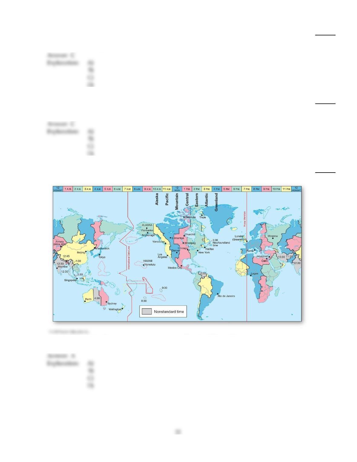
92)
If you wanted a map with a lot of detail of a small area you would want a
92)
A)
a world globe.
B)
a small scale map.
C)
a large scale map.
D)
an intermediate scale.
93)
An angular distance measured north or south of the equator is termed
93)
A)
longitude.
B)
zenith.
C)
latitude.
D)
Greenwich distance.
94)
As Figure 1.15 shows, the International Dateline follows generally the
94)
A)
daylight savings line.
B)
prime (0°) meridian.
C)
180° meridian.
D)
principal meridian.
95)
Who made a significant, early contribution to cartography by adding a grid and orienting the map
with north at the top? He also divided the circumference of Earth into 360°, with each degree
comprising 60 minutes, and each minute comprising 60 seconds.
95)
A)
Magellanin the sixteenth century A.D.
B)
Pythagorasin the sixth century B.C.
C)
Ptolemyin the second century A.D.
D)
Sir Isaac Newtonin the seventeenth century A.D.
96)
Relative to the five fundamental themes of geography, latitude and longitude refer to
96)
A)
location.
B)
place.
C)
human–Earth relationships.
D)
movement.
E)
regions.
97)
Which of the following best describes the condition of steady–state equilibrium?
97)
A)
Systems slowly adjust to long–term changes in input and output.
B)
System inputs always exactly balance outputs so the system never changes.
C)
System inputs and outputs fluctuate around a stable average so the system does not move far
from its average condition.
D)
System inputs produce large, random fluctuations in output, forcing the system into a new
state of equilibrium.
98)
If you were standing at 20° north latitude you would be within which latitudinal geographic zone?
98)
A)
Subtropical
B)
Midlatitude
C)
Equatorial
D)
Tropical
E)
Subarctic
99)
Which type of map scale would be appropriate to use if the map were to be enlarged by
photocopying?
99)
A)
Written
B)
Graphic
C)
Relative
D)
Representative fraction
100)
The word spatial refers to
100)
A)
things that are unique and special.
B)
eras of time.
C)
items that relate specifically to society.
D)
the nature and character of physical space and the distribution of phenomena within it.
101)
According to the text, the three inorganic Earth realms are the
101)
A)
atmosphere, geoid, and homosphere.
B)
hydrosphere, lithosphere, and atmosphere.
C)
stratosphere, magnetosphere, and troposphere.
D)
thermosphere, lithosphere, heterosphere.
102)
Latitude is
102)
A)
the angular distance measured north or south of the equator.
B)
portrayed on a globe as lines that cross the equator at right angles.
C)
the basis for establishing meridians.
D)
the angular distance measured east or west of a prime meridian.
103)
The key idea behind the scientific method is
103)
A)
an appeal to supernatural explanations when natural explanations have not yet been found
for a phenomenon.
B)
unbridled speculation about the world.
C)
the use of intuition in testing theories.
D)
the testing of ideas through controlled observations and experiments.
104)
Travelers flying west from Los Angeles (118° W) to Tokyo (139° E) will cross the ________ and, as a
result, they will ________ when crossing this meridian.
104)
A)
prime meridian; lose a day (Example: Saturday becomes Sunday.)
B)
prime meridian; gain a day (Example: Sunday becomes Saturday.)
C)
International Dateline; lose a day (Example: Saturday becomes Sunday.)
D)
International Dateline; gain a day (Example: Sunday becomes Saturday.)
105)
A physical geographer would likely NOT study
105)
A)
the effects of the removal of dams on the Elwha River in Washington.
B)
the impact of Hurricane Sandy’s landfall along the U.S. East Coast.
C)
the 9.0 magnitude earthquake in Japan in 2011.
D)
The diffusion of various religions from the so–called Middle East.
106)
A scale of 1 inch = 8 miles is an example of a
106)
A)
written scale.
B)
relative scale.
C)
graphic scale.
D)
representative fraction.
107)
Which of the following describes the property of equal area on a map?
107)
A)
Conformality
B)
Equidistance
C)
Proximity
D)
Equivalence
108)
If City A is located 35° west of City B, the time at City A is ________ that at City B.
108)
A)
earlier than
B)
later than
C)
earlier during daylights saving only than
D)
the same as
109)
If it is 10:00 A.M. in Miami, Florida (Eastern time zone), what time is it in Los Angeles, California,
located 3 time zones to the west in the Pacific Time zone?
109)
A)
8 A.M.
B)
7 A.M.
C)
2 P.M.
D)
1 P.M.
110)
A line connecting all points along the same longitudinal angle is called a
110)
A)
meridian.
B)
great circle.
C)
parallel.
D)
prime latitudinal angle.
111)
Which of the following statements about Earth is CORRECT?
111)
A)
The equatorial diameter is 42 km (26 mi.) greater than the polar diameter.
B)
Earth is the second largest planet in the solar system.
C)
It is elongated.
D)
Earth is perfectly spherical.
112)
Which of the following is FALSE?
112)
A)
GIS stands for geographic information system.
B)
GIS represents an important planning tool.
C)
Satellite weather images are an example of remote sensing.
D)
A GIS model does not require the use of a map.
TRUE/FALSE. Write ‘T’ if the statement is true and ‘F’ if the statement is false.
113)
The “balance of nature” that characterizes well–functioning ecosystems occurs because of
predominantly positive feedback mechanisms.
113)
114)
Negative feedback tends to stabilize a system.
114)
115)
A map scale of 1:24,000 is considered a small scale as compared to a scale of 1:20,900,000, which is
considered a large scale.
115)
116)
There are 180° of latitude (90° N and S, respectively) and 360° of longitude (180° E and W,
respectively).
116)
117)
A Mercator projection preserves area of all poleward geographic features.
117)
118)
Photosynthesis in a plant leaf is an example of an open–system operation.
118)
119)
The prime meridian and the 180th meridian are opposite halves of the same great circle.
119)
120)
Longitude measures distances east or west of a prime meridian on Earth’s surface.
120)
121)
Coordinated Universal Time is the present name for world standard time.
121)
122)
Pure science frequently involves the making of value judgments about the moral or political
correctness of a fact, idea, or theory.
122)
123)
Areas that display a degree of uniformity are called regions.
123)
124)
GIS use satellites to find locations precisely.
124)
125)
Positive feedback tends to amplify or encourage response in system operations.
125)
126)
Because scientific ideas are tested, they can be corrected when they are wrong.
126)
127)
A model is essentially a simplification of natural systems.
127)
128)
When Daylight Saving Time is in effect, clocks “spring forward” one hour in the Spring (Example:
1:00 A.M. becomes 2:00 A.M.) and “fall back” one hour in the Fall (Example: 2:00 A.M. becomes 1:00
A.M.).
128)
129)
Latitude is the angular distance measured north or south of the equator from the center of Earth
and it describes a parallel line on the surface.
129)
130)
Global positioning systems, while useful in navigation, have little utility in physical geography.
130)
131)
All parallels are 360° in length.
131)
132)
An equivalent map projection preserves true shape.
132)
133)
A standard parallel is a line of tangency.
133)
134)
Scientific theories are capable of generating predictions.
134)
135)
Migration and diffusion across Earth’s surface is described under the principal geographic theme of
movement.
135)
136)
The geographic theme of place refers to absolute and relative position on Earth.
136)
137)
A meridian is 360° in length.
137)
138)
The day officially changes on Earth at the prime meridian.
138)
139)
If it is July 3rd in Tokyo (139° E), it is July 4th in Los Angeles (118° W).
139)
140)
Geodesy is the science concerned with the size and shape of Earth.
140)
141)
The Greek astronomer, geography, and mathematician Ptolemy, despite his early works in
mapping, has had little lasting impact on cartography.
141)
142)
Maps that are intended to show spatial distributions should be based on projections that minimize
area distortion, rather than shape distortion.
142)
143)
Conditions that change in an experiment or model are called variables.
143)
144)
“Longitude” is the name of an angle, and “meridian” is the name of an imaginary line that connects
all points along the same longitude.
144)
145)
The midlatitudes stretch from approximately 66.5° N/S to the poles.
145)
146)
A geographic information system is unable to create maps with a three–dimensional perspective.
146)
147)
A large scale map shows a large area, but with less detail than a small scale map.
147)
148)
The globe is the only map that accurately portrays all spatial relationships characteristic of Earth’s
surface.
148)
149)
GIS can create dynamic maps for visualization purposes.
149)
150)
Geography is a discipline primarily concerned with place names.
150)
151)
A great circle route is the shortest distance between any two points on Earth’s surface.
151)
152)
The essential approach in geographic studies is spatial analysis.
152)
153)
A sensor that measures the emitted radiation of an object is an example of passive remote sensing.
153)
154)
The Landsat series of satellites is an example of passive remote sensing.
154)
155)
There are 48 time zones, each approximately 7.5° in width.
155)
156)
A rhumb line is a line of constant direction (crosses all meridians at the same angle).
156)
157)
LiDAR is an example of passive remote sensing?
157)
ESSAY. Write your answer in the space provided or on a separate sheet of paper.
158)
Use examples to distinguish positive and negative feedback loops.
159)
What are Earth’s abiotic and biotic systems?
160)
Distinguish between active and passive remote sensing, and describe the applications of each.
161)
Briefly describe the difference between a system and a model.
162)
What are the four classes of map projections?
163)
Describe what distinguishes physical geography from human and cultural geography.
164)
Use examples to distinguish an open system from a closed system.
165)
What is a geographic information system? What are some potential GIS applications?
166)
Describe the differences between matter and energy.
167)
List and briefly describe Earth‘s four spheres.
168)
List the five principal themes of modern geographic education.
169)
What are the three primary methods of expressing scale on maps?
170)
What is geodesy?
171)
What is a great circle? What are small circles?
172)
Why is the term “spatial” so important in geography?
173)
What is GPS? Give several examples of its utility in physical geography.
174)
How can feedback affect a system? Give examples of positive and negative feedback.
175)
What is a hypothesis? How does it differ from a theory?
176)
Follow the scientific method from the initial perception of phenomena to a general theory about the
phenomena.
Answer Key
Testname: C1
33
Answer Key
Testname: C1
Answer Key
Testname: C1
Answer Key
Testname: C1
36