Chapter 1 2 A degree of longitude at the equator is roughly

subject Type Homework Help
subject Pages 13
subject Words 4304
subject Authors Robert W. Christopherson

Unlock document.

This document is partially blurred.
Unlock all pages and 1 million more documents.
Get Access
page-pf1
59) A degree of longitude at the equator is roughly________ in length. A degree of longitude at
the poles is ________ in length
A) 111 km; 111 km
B) 0 km; 111 km
C) 111 km; 0 km
D) 0 km; 56 km
E) 56 km; 0 km
60) An angular distance measured east or west of a prime meridian from the center of Earth is
termed
A) longitude.
B) latitude.
C) zenith.
D) Greenwich distance.
61) How far north you live from the equator is measured as your ________, whereas an
imaginary line marking all those places at that same distance north of the equator is called a
________.
A) longitude; meridian
B) meridian; longitude
C) latitude; parallel
D) parallel; latitude
E) location; place
page-pf2
62) Which of the following is true regarding the 0° prime meridian?
A) There was no way of determining this meridian at sea until as late as AD 1760.
B) The prime meridian passes through Paris, France.
C) International agreement regarding the location of the prime meridian was not resolved until
the 1980s when a treaty was completed.
D) The key to measuring angular distances east and west of the prime meridian was the
development of accurate compasses.
63) The basis for defining the length of a day is the fact that
A) Earth rotates east to west.
B) Earth moves through 365.25 days a year in its orbit about the Sun.
C) Earth rotates on its axis in 24 hours; i.e., it rotates 15° of longitude per hour.
D) Earth does not rotate; rather, it revolves.
64) The meridian opposite of Earth's prime meridian (0° longitude) is called
A) secondary meridian.
B) the anti-meridian.
C) the equator.
D) the International Date Line.
page-pf3
65) Latitude is
A) the angular distance measured north or south of the equator.
B) the angular distance measured east or west of a prime meridian.
C) the basis for establishing meridians.
D) portrayed on a globe as lines that cross the equator at right angles.
66) Longitude is
A) an angular distance measured north or south of the equator.
B) an angular distance measured east or west of a prime meridian.
C) the basis for establishing parallels.
D) determined by Sun altitude above the horizon.
67) If you were standing at 20° north latitude you would be within which latitudinal geographic
zone?
A) tropical
B) midlatitude
C) equatorial
D) subarctic
E) subtropical
page-pf4
68) If you were standing at 60° north latitude you would be within which latitudinal geographic
zone?
A) subantarctic
B) midlatitude
C) antarctic
D) subarctic
E) subtropical
69) A line connecting all points along the same longitudinal angle is called a
A) meridian.
B) parallel.
C) prime latitudinal angle.
D) great circle.
70) Longitude is conveniently determined at sea using
A) a clock without a pendulum (i.e. a marine chronometer).
B) noon Sun angles.
C) magnetic compasses.
D) sextants.
page-pf5
71) Which of the following is not true of meridians?
A) They cross parallels at right angles.
B) They are lines that run in an east-west direction.
C) All meridians are the same length.
D) They are used to measure east-west angular distances.
72) Which of the following is true of the prime meridian?
A) It is used to determine latitude using lines that run east and west.
B) It was first used in the 1500s at the time of initial circumnavigation voyages.
C) It was not established until 1884 and is centered on an observatory near London.
D) It is that place on Earth where the days officially change.
73) The letters A.M. stand for
A) after midnight.
B) after morning.
C) ante majolica.
D) ante meridiem.
E) after meridian.
page-pf6
74) The letters P.M. stand for
A) prior majolica.
B) previous morning.
C) post meridiem.
D) possible meridian.
75) Coordinated Universal Time (UTC) is
A) the same as Greenwich Mean Time (GMT).
B) established 24 standard meridians around the globe at equal intervals from the prime
meridian.
C) replaced Greenwich Mean Time (GMT) and became the legal reference for official time in all
countries.
D) two-hours ahead of Zulu time, indicating the single moment when all locations on the planet
are on the same calendar day.
76) Which of the following is true of the length (as measured in kilometers) of a degree of
latitude?
A) It is mostly constant at all latitudes.
B) It is longer near the equator than near the poles.
C) It is shorter near the equator than near the poles.
D) It is shorter near the prime meridian than near the international dateline.
page-pf7
77) If City A is located 35° west of City B, the time at City A is ________ that at City B.
A) earlier than
B) later than
C) the same as
D) earlier during daylights saving only than
78) The difference in Sun time between two places located 30° in longitude apart from one
another is
A) 30 seconds.
B) 30 minutes.
C) one hour.
D) two hours.
E) three hours.
page-pf8
79) If a clock on a ship indicates that it is 2:00 P.M. in its home port, while another clock on the
ship indicates that it is 12:00 noon at the ship's present location, what is the difference in
longitude between the ship's position and its home port?
A) The ship is 2° east of its home port.
B) The ship is 2° west of its home port.
C) The ship is 30° east of its home port.
D) The ship is 30° west of its home port.
E) The ship is 45° west of its home port.
80) If you began a trip at 60° west, 20° north and traveled 120° farther west and 50° south, your
new position would be
A) the International Dateline at 70° north latitude.
B) the International Dateline at 30° south latitude.
C) the Greenwich meridian at 70° north latitude.
D) the Greenwich meridian at 30° south latitude.
E) 30° north, 120° west.
page-pf9
81) If it is 10:00 PM on July 3rd at 30° west, what date and time is it at 15° east?
A) July 3rd; 11 P.M.
B) July 3rd; 9 P.M.
C) July 3rd; 6 P.M.
D) July 4th; 1 A.M.
E) July 4th; 2 A.M.
82) Travelers flying west from Los Angeles (118° W) to Tokyo (139° E) will cross the ________
and, as a result, they will ________ when crossing this meridian.
A) International Dateline; gain a day (Example: Sunday becomes Saturday.)
B) International Dateline; lose a day (Example: Saturday becomes Sunday.)
C) prime meridian; gain a day (Example: Sunday becomes Saturday.)
D) prime meridian; lose a day (Example: Saturday becomes Sunday.)
83) Standard time zones
A) have yet to be generally established.
B) are 15° wide because Earth rotates through that distance in one hour.
C) are only used in the developed countries.
D) are spaced at 5° intervals of longitude in North America.
page-pfa
30
84) If it is 10:00 A.M. in Miami, Florida (Eastern time zone), what time is it in Los Angeles,
California, located 3 time zones to the west in the Pacific Time zone?
A) 7 A.M.
B) 8 A.M.
C) 1 P.M.
D) 2 P.M.
85) Which of the following is true of the 1884 treaty establishing the prime meridian (0°)?
A) Each country selected its own prime meridian for their marine maps.
B) The Greenwich meridian was established as the prime meridian by the treaty.
C) The United States designated the Washington meridian for land maps and marine maps.
D) No consensus was met at the 1884 treaty, putting off the decision until a 1907 treaty was
passed.
86) UTC refers to
A) the International Date Line.
B) Universal Time Conference.
C) Coordinated Universal Time.
D) Universal Time Circles.
87) UTC is based on
A) very precise pendulum motion in Greenwich, U.K.
page-pfb
B) Big Ben
C) average time calculations from atomic clocks collected worldwide
D) the pulse rate of pulsar stars.
88) The practice of setting time ahead or behind during the year, out of coordination with the
Sun, is termed
A) Coordinated Universal Time.
B) Daylight Saving Time.
C) Standard time.
D) Greenwich Mean Time.
89) A great circle is
A) any parallel of latitude.
B) the longest distance between two places on the surface of Earth.
C) a circle of circumference whose center coincides with the center of Earth.
D) a correct magnetic compass direction on a flat map.
page-pfc
90) Earth's equator is an example of
A) a small circle.
B) a great circle.
C) a prime meridian.
D) a line of equal longitude.
91) The part of geography that embodies map making is known as
A) theodesy.
B) geodesy.
C) cartography.
D) calligraphy.
92) A scale of 1 inch = 8 miles is an example of a
A) representative fraction.
B) graphic scale.
C) written scale.
D) relative scale.
page-pfd
93) A scale of 1:24,000 is regarded as
A) a large scale.
B) a small scale compared to a scale of 1:20,900,000.
C) an intermediate scale.
D) a scale appropriate for a world globe.
94) A scale of 1:900,000 is ________a scale of 1:24,000.
A) larger than
B) equal to
C) smaller than
D) twice as much as
95) If you wanted a map with a lot of detail of a small area you would want a
A) a large scale map.
B) a small scale map.
C) an intermediate scale.
D) a world globe.
page-pfe
96) A map scale of 1:63,360 is equivalent to
A) one inch on the map equals 2,000 feet on the ground.
B) one inch on a map equals 1 mile on the ground.
C) one inch on a map equals 5 miles on the ground.
D) one inch on the map equals 24,000 inches on the ground.
97) The transformation of a spherical global to a 2D surface is a
A) diagram.
B) cone.
C) map projection.
D) globe.
98) A scale given as "one centimeter to one kilometer" is an example of a
A) representative fraction.
B) graphic scale.
C) written scale.
D) relative scale.
page-pff
99) Which type of map scale would be appropriate to use if the map were to be enlarged by
photocopying?
A) written
B) graphic
C) representative fraction
D) relative
100) The larger the scale of a map, the ________ the area covered by the map and the ________
detail it provides.
A) larger; more
B) larger; less
C) smaller; more
D) smaller; less
101) The larger the denominator in a representative fraction, the ________ the scale of the map.
A) larger
B) smaller
page-pf10
102) The amount of detail on large scale maps is generally ________ than on than on small scale
maps.
A) greater
B) less
C) It is impossible to compare the relative detail of the same features on maps of different scales.
103) Which of the following describes the property of equal area on a map?
A) equivalence
B) conformality
C) proximity
D) equidistance
104) Which map project preserves the property of true shape?
A) equivalent
B) conformal
C) proximal
D) equidistant
page-pf11
105) Which of the following possesses all of Earth's properties of area, shape, direction,
proximity, and distance, correctly?
A) Mercator projection
B) Alber's equal-area conic projection
C) Robinson projection
D) a world globe
106) Where does the greatest distortion in a Mercator projection occur?
A) the equator.
B) towards the poles.
C) it varies.
D) there is no distortion in a Mercator projection.
107) A line of tangency (also called a standard line) is a line
A) that always corresponds to a great circle.
B) along which shearing occurs.
C) along which no distortion occurs.
D) divides Earth into two equal halves.
page-pf12
108) On which one of the following projections do great circle routes appear as straight lines?
A) Mercator projection
B) Goode's homolosine projection
C) any conic projection
D) a gnomonic projection
109) On the Mercator projection, areas at high latitudes appear
A) larger than areas of the same size located nearer to the equator.
B) smaller than areas of the same size located nearer to the equator.
C) the same size as areas of the same size located nearer to the equator.
110) Which map projection is best at reducing distortion?
A) All map projections distort.
B) Mercator projection.
C) Robinson projection.
D) Albers equal-area projection.
page-pf13
111) Which of the following is the most popular and widely used map prepared by the U.S.
Geological Survey?
A) a topographic map
B) a Robinson projection
C) a resources map
D) portolan chart
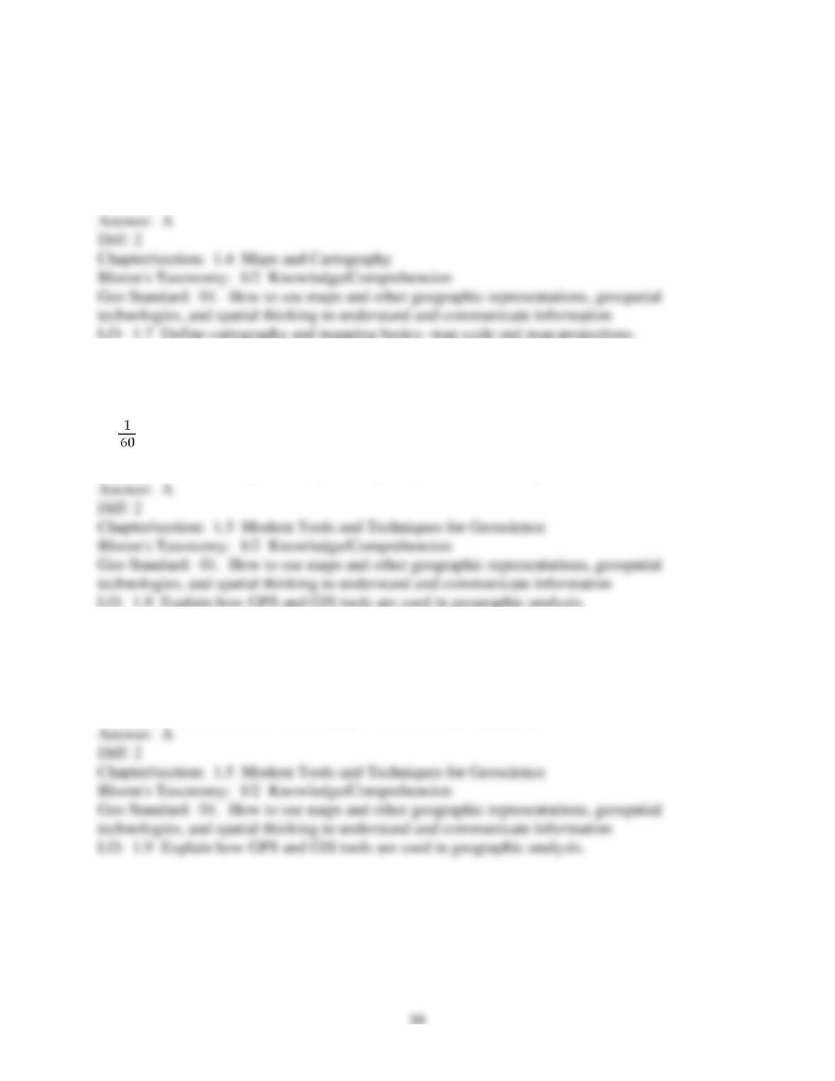
112) GPS units are
A) accurately allow determination of longitude and latitude.
B) a metric version of longitude and latitude.
C) th of a Greenwich Precision Second.
D) not available to the public; they are only available to the military.
113) Which of the following is true about Global Positioning System (GPS)?
A) GPS helped accurately determined the height of Mt. Everest.
B) GPS is the same as remote sensing.
C) GPS is used solely by the military, who share information with physical geographers.
D) GPS has no scientific uses, but are great for recreational purposes.

Trusted by Thousands of
Students

Here are what students say about us.

Copyright ©2022 All rights reserved. | CoursePaper is not sponsored or endorsed by any college or university.