
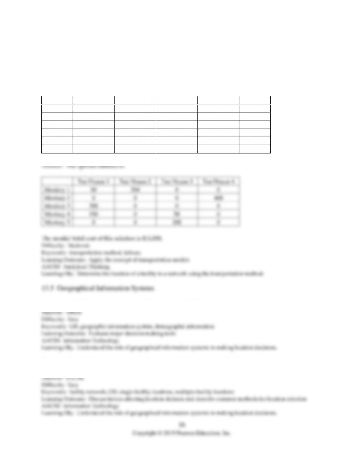
23) Five sources exist for the civet cat coffee favored by true coffee connoisseurs. The four processing centers
for these coffee beans are scattered about the country, each with a different level of demand. The five sources
all face different cost structures for transporting their beans, the prices in the table reflect a dollar cost per 50
pound bag of coffee beans. The total amounts supplied by each source and demanded by each destination are
also shown in the table, and as luck would have it, the total supply equals the total demand. What is the
optimal shipping scheme such that the total transportation cost is minimized?
Destination 1
Destination 2
Destination 3
Destination 4
Supply
Source 1
$5
$7
$2
$9
400
Source 2
$8
$6
$3
$4
400
Source 3
$11
$15
$18
$11
300
Source 4
$9
$6
$4
$3
200
Source 5
$7
$9
$11
$8
200
Demand
500
350
250
400
1,500
Destination 1
Destination 2
Destination 3
Destination 4
Source 1
150
0
250
0
Source 2
0
350
0
50
Source 3
150
0
0
150
Source 4
0
0
0
200
Source 5
200
0
0
0
The total cost of this solution is $8,850
Difficulty: Moderate
Keywords: transportation method, tableau
Learning Outcome: Apply the concept of transportation models
AACSB: Analytical Thinking
Learning Obj.: Determine the location of a facility in a network using the transportation method.
24) As legend has it, Buddhist monks trained monkeys to deftly gather the youngest leaves from the tops of
wild tea trees. The monkey-harvested leaves are unbroken and evenly sized to create the finest oolong tea in
the world. There are five plantations that use monkeys for this task and four tea centers where the leaves
must be shipped. The cost to send a kilogram of leaves from each plantation to each tea center is shown in the
table. Note that supply equals demand in this scenario. What is the optimal shipping scheme such that the
total transportation cost is minimized?
Tea House 1
Tea House 2
Tea House 3
Tea House 4
Supply
Monkey 1
$12
$13
$23
$15
400
Monkey 2
$6
$17
$11
$4
400
Monkey 3
$6
$14
$13
$19
300
Monkey 4
$8
$10
$6
$8
200
Monkey 5
$21
$22
$5
$21
200
Demand
500
350
250
400
1,500
Tea House 1
Tea House 2
Tea House 3
Tea House 4
Monkey 1
50
350
0
0
Monkey 2
0
0
0
400
Monkey 3
300
0
0
0
Monkey 4
150
0
50
0
Monkey 5
0
0
200
0
The monks‘ total cost of this solution is $11,050.
Difficulty: Moderate
Keywords: transportation method, tableau
Learning Outcome: Apply the concept of transportation models
AACSB: Analytical Thinking
Learning Obj.: Determine the location of a facility in a network using the transportation method.
13.5 Geographical Information Systems
1) A geographic information system contains demographic information.
2) Geographical Information System (GIS) tools are useful in solving single-facility location problems, but
because of software limitations, cannot be used for determining multiple-facility locations.
3) When using Geographical Information System (GIS) tools to solve multiple-facility location problems, an
analyst may also use load-distance scores and center of gravity data to arrive at trial locations.
4) Because Geographical Information System (GIS) tools are primarily quantitative in nature, a firm’s
managerial criteria, such as proximity to major metropolitan areas, are not able to be included in the GIS
analysis.
5) Which of these is not identified as a component of a geographical information system?
A) hardware
B) data
C) software
D) network
6) Which of these is not a common functionality of a GIS?
A) data storage
B) communication
C) map display
D) modeling
37
7) Which of the following statements concerning the use of the Geographical Information System (GIS)
method for locating multiple facilities is true?
A) GIS helps with general facility locations, but is not able to identify specific locations because the
transportation structure of roads and interstate highways can‘t be included in the GIS databases.
B) Load-distance scores and center of gravity data can be merged with customer databases to arrive at trial
locations for facilities.
C) When locating two new facilities, the entire operating area is split into four subregions, two for each new
facility, so the best two locations from the four subregions can be selected.
D) One weakness of the GIS method is that it is slow and cumbersome, and significant time must be allowed
in order to reach a reasonable multiple-facility location decision.
8) Which of the following is an example of an organization using the Geographical Information System (GIS)
method for locating multiple facilities?
A) A company that is searching for a location for its combination manufacturing plant and warehouse to
better serve several geographical regions of the country.
B) Load-distance scores and center of gravity data being used to locate a facility to provide better customer
service for multiple customers.
C) A company that is searching for a manufacturing plant location that provides enough space for the plant
to double in size over the next five years.
D) A hospital network that wants to locate several satellite medical facilities in outlying areas to better serve a
major metropolitan area.
9) What are the components and capabilities of a geographical information system?
Answer: A geographical information system (GIS) is a system of computer software, hardware, and data that
the firm’s personnel can use to manipulate, analyze, and present information relevant to a location decision.
13.6 Inventory Placement
1) One disadvantage of centralized placement is increased shipping costs from the distribution center to the
customer.
2) Forward placement is a reduction in inventory and safety stock because of the merging of variable
demands from customers.
3) Which one of the following statements on inventory placement of finished goods is best?
A) Forward placement might help reduce transportation cost.
B) Forward placement is consistent with a competitive priority that calls for customization.
C) Inventory pooling should be avoided when demand in various regions fluctuates month to month.
D) Backward placement is consistent with a competitive priority that calls for fast delivery times.
4) Which location shift would qualify as forward placement?
A) from the manufacturer to a distribution center
B) from the retailer to the wholesaler
C) from the wholesaler to the manufacturer
D) from the retailer to the manufacturer
39
5) The auto supply stores in the metroplex use a common database to track inventory and actually have very
little in each location. Instead, customer requests are typically met with the reply, “We have some in our
depot and can get it here by truck after 5 pm.” This is an example of:
A) forward placement.
B) centralized placement.
C) backward placement.
D) depot placement.
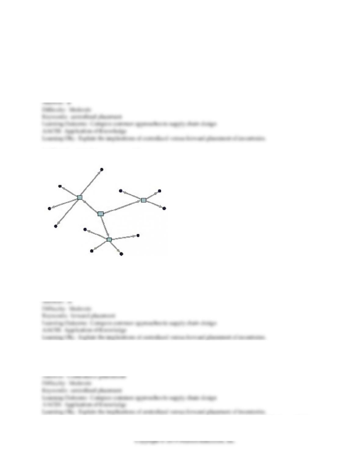
6) What does this diagram represent?
A) forward placement
B) inventory pooling
C) a geographical information system
D) interchangeable parts
7) Cornelius Controlfreak insisted that his manufacturing plant also be the sole location for all finished goods
inventory. If any customer placed an order, they knew it would come from the only place on Earth that had a
ready supply, Cornelius’ plant warehouse. ________ was alive and well thanks to this approach.
8) ________ is a reduction in inventory and safety stock because of the merging of variable demands from
40
customers.
9) ________ involves locating the stock closer to customers at a warehouse, distribution center, or retailer.
10) Discuss the trade-offs with locating the inventory at the factory versus locating it closer to the customer at
a warehouse, distribution center, wholesaler, or retailers.
Answer: Locating inventory at a company‘s factory or warehouse constitutes centralized placement, thereby
allowing a firm to take advantage of inventory pooling. Inventory pooling permits the producer to reduce the
13.7 A Systematic Location Selection Process
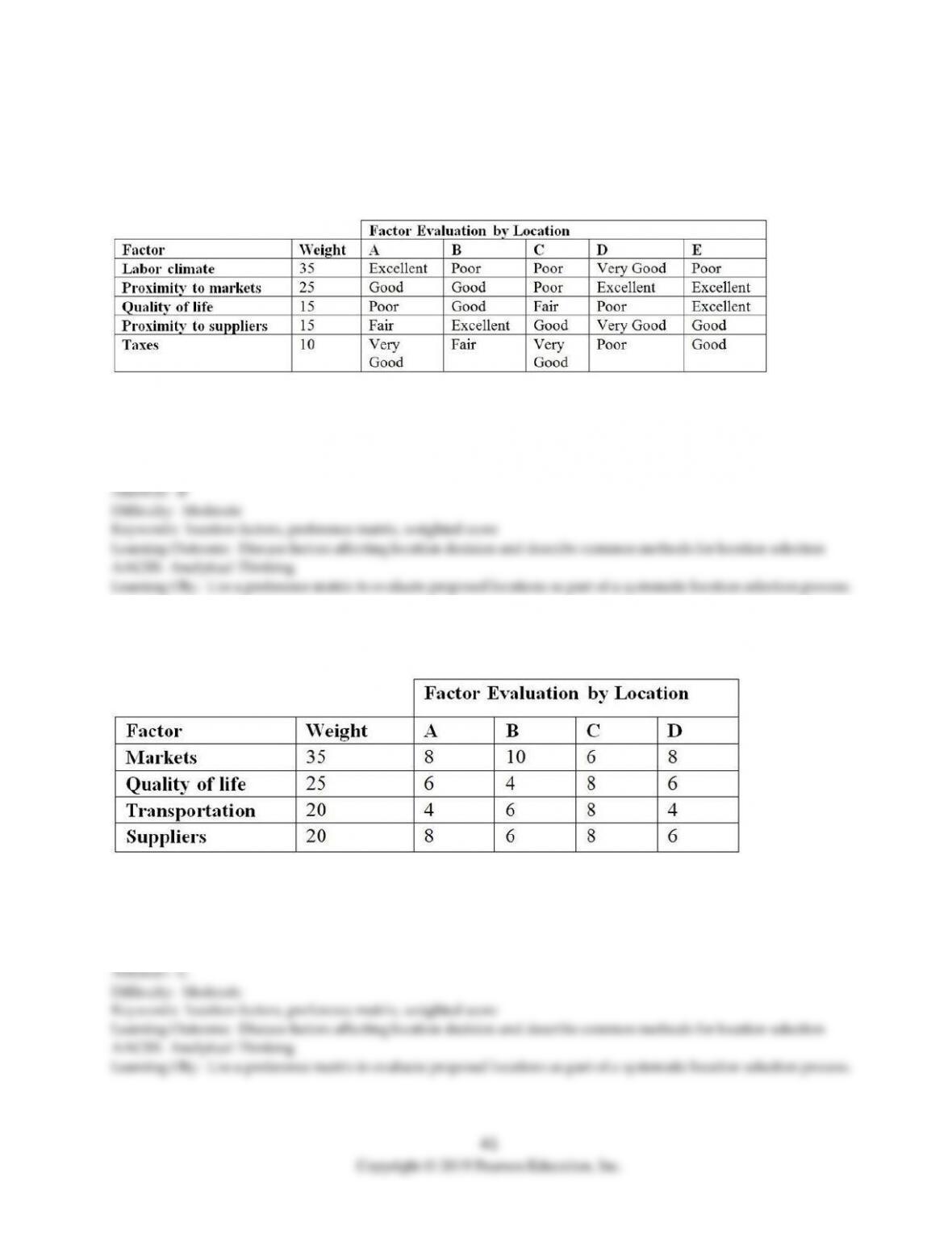
1) Widgets, Inc. wishes to locate two new manufacturing facilities. Based on the following subjective criteria,
where should the new facilities be located? (Excellent = 5, Very good = 4, Good = 3, Fair = 2, Poor = 1)
A) B and D
B) A and D
C) C and D
D) D and E
2) McKenna Restaurant wishes to open a new store. Based on the following subjective criteria, where 10 is
excellent and 0 is poor, where should the new store be located?
A) A
B) B
C) C
D) D
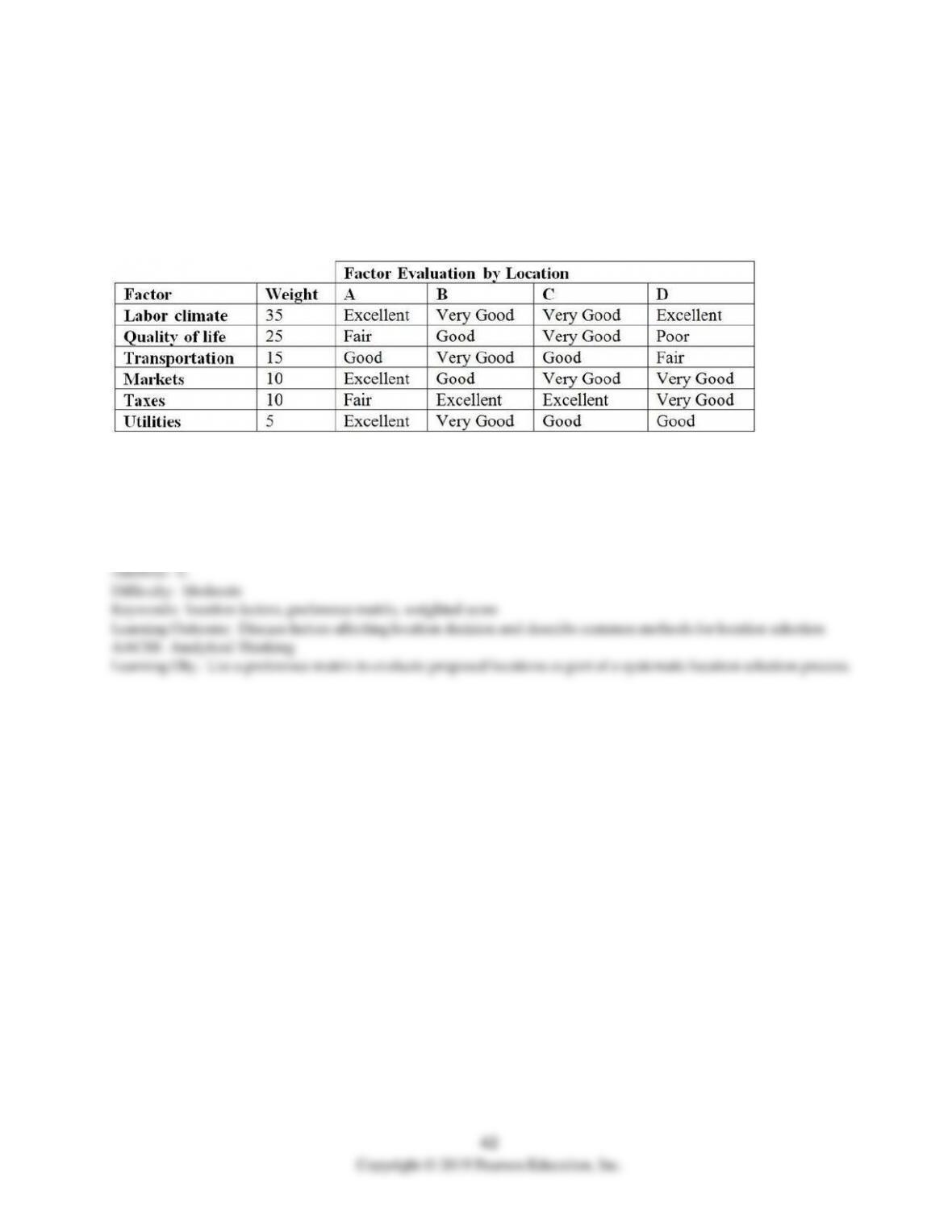
3) The point has been reached where a biotechnology research and development company must expand by
building a new facility. The search has been narrowed to four locations, all of which are acceptable to
management. The assessment of these sites is being made on the basis of the six subjective location factors
that follow. Management has agreed to use a five-point scale (Excellent = 5, Very good = 4, Good = 3, Fair = 2,
Poor = 1) to quantify and compare their subjective opinions about the relative goodness of the sites. The
weight reflects the importance of each factor in the decision.
Calculate the weighted score for each alternative. Which location would you recommend?
A) A
B) B
C) C
D) D
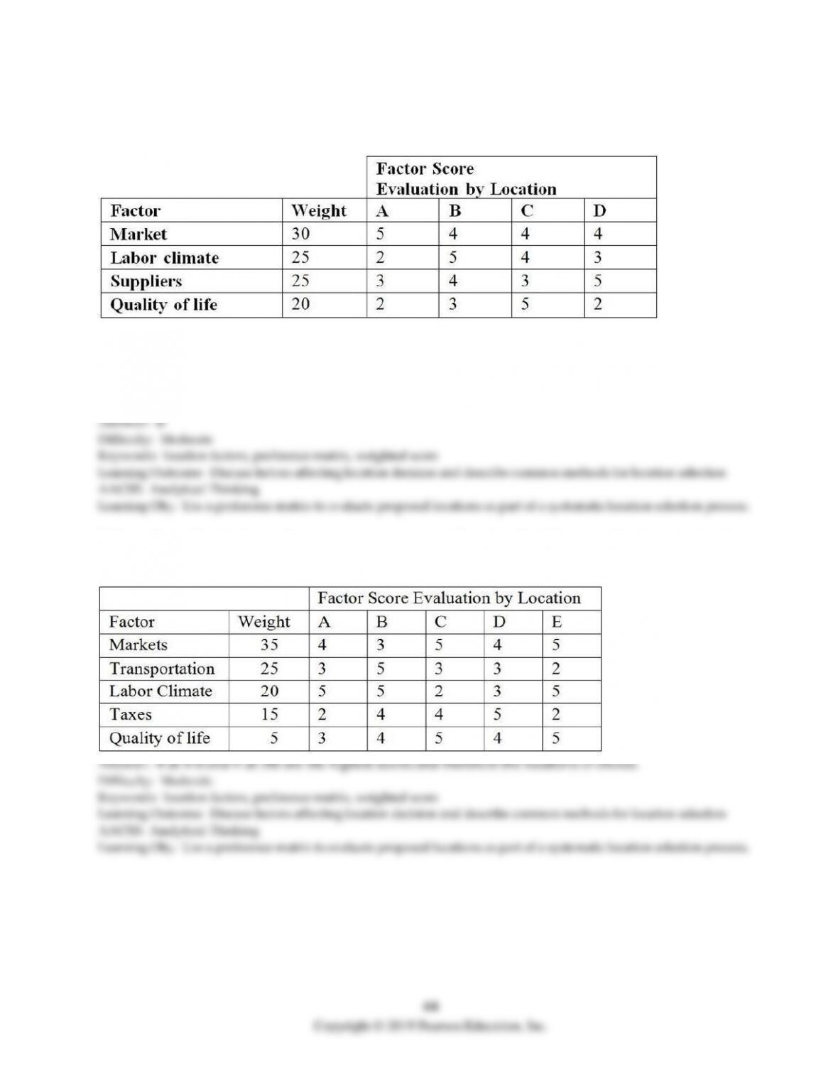
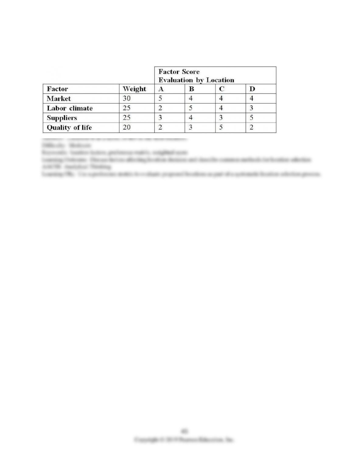
4) Acme Fasteners desires to locate a new facility. Based on preliminary analysis, the choice has been reduced
to four locations: A, B, C, and D. These four locations were rated on a scale from 1 (worst) to 10 (best) on each
of four criteria. Each criterion was also weighted to indicate its importance (i.e., the higher the weight, the
more important). The list of ratings and weights follows.
Based on weighted scores, where should Acme locate its new facility?
A) A
B) B
C) C
D) D
5) Sweet Candy, Inc. wishes to open two new stores. Based on the following subjective criteria, where should
the new stores be located? The higher the score, the better.
A) A and B
B) B and C
C) B and D
D) B and E
6) The Hunan Restaurant wishes to locate a new facility. Based on the following subjective criteria, where
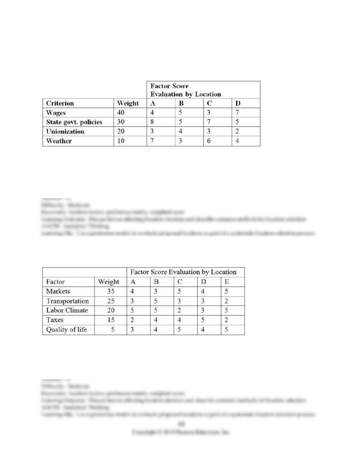
should the new facility be located? (Very good = 5, Good = 4, Fair = 3, Poor = 2, and Very poor = 1)
A) A
B) B
C) C
D) D
7) Sweet Sweet Candy, Inc. wishes to open two new stores. Based on the following subjective criteria, where
should the new stores be located? The higher the score, the better.
8) The Dhaba Restaurant wishes to locate a new facility. Based on the following subjective criteria, where
should the new facility be located? (Very good = 5, Good = 4, Fair = 3, Poor = 2, and Very poor = 1)