Geog 150 Spring 2017
Geography of the U.S. Montello
Study Guide for Midterm Exam
You will not be asked about specific human or physical features in Canada. However, for the
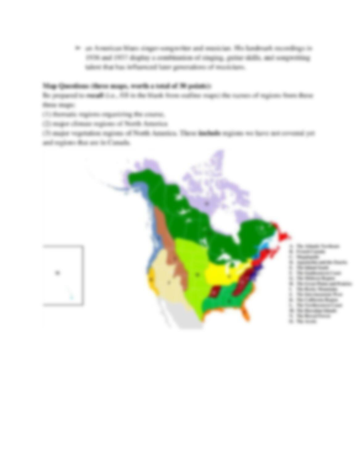
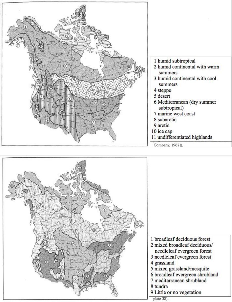
Map Questions (described below), you will be asked the names of all regions, including those
partially or completely in Canada.
Regions covered so far: The Atlantic Northeast, Megalopolis, Appalachia and The Ozarks, The
Inland South, The Southeastern Coast
For each region covered so far, know major information about:
states wholly or partially in the region; names and approximate sizes of large cities; overall
character; physical geography—climate, topography, soil, water bodies, vegetation, wildlife;
human geography—population size and density, urbanization, ethnic groups, settlement
histories, economic activities (including tourist attractions)
Be able to identify the main region (pre-European) for the following Indian groups:
Abenaki, Biloxi, Cherokee, Chickasaw, Choctaw, Creek, Cusabo, Delaware, Iroquois League,
Mohegan (Mohican), Natchez, Oneida, Onondaga, Osage, Penobscot, Seminole, Shawnee and
Ohio Valley Tribes
● Abenakis: Vermont, New Hampshire, and Maine
● Biloxi: Biloxi, Mississippi.
● Cherokee: Alabama, Georgia, Kentucky, Mississippi, Tennessee, North Carolina, South
Carolina, Virginia and West Virginia
● Chickasaw: Mississippi, Alabama, Tennessee, Kentucky and Missouri
● Creek: Tennessee, Georgia, Alabama, and northern Florida,
● Cusabo: south carolina
● Delaware: New Jersey
● Iroquois League:
● Mohegan (Mohican): Connecticut
● Natchez: Mississippi
● Oneida: New York
● Onondaga: New York
● Osage: Missouri, Arkansas, Kansas, and Oklahoma
● Penobscot: Maine
● Seminole: Florida
● Shawnee: Ohio and Kentucky eastward to West Virginia,
Also, know these concepts and terms from each lecture:
Lecture 1:
● definition of geography;
➢ Study of earth
● physical (natural) and human geography;
● regional and systematic geography;
● definition of regions;
➢ Pieces of (near-) Earth surface
➢ Internally similar, externally dissimilar
● boundary vagueness and permeability;
● hierarchical organization of regions;
➢ More or less important
● thematic, functional, cognitive (perceptual), administrative regions;
➢ Thematic: basis of regional geography, defined by themes (boundary vague)
➢ Functional: areas defined by connections (vague)
➢ Cognitive: how people informally organize places in their minds (vague)
➢ Administrative: by law or treaty (precise)
● watersheds, continental divides;
➢ Functional
➢ Continental divides at the largest scale
● size and shape of planet Earth;
➢ Sphere
➢ 8,000 miles diameter
➢ 25,000 miles circumference
● % water and land on Earth; 71% water, 29% land
● parallels of latitude and meridians of longitude (graticule);
● Tropics,
➢ Cancer and Capricorn 23.5 N and S
● temperate zones, polar zones;
● orrery;
➢ Illustrates the relative positions and motions of bodies in solar system
● insolation at top and bottom of the atmosphere;
➢ On top, varies with latitude and seasons
➢ On bottom, varies with cloud cover, particles and pollutants, ground slope and
aspect, tree cover
● earth-sun relations, seasons, and daylight patterns;
● ecliptic;
➢ Relate to seasons
➢ Different times of year
● latitude and longitude of U.S.;
➢ North: alaska
➢ South: hawaii
➢ West: alaska
➢ East: alaska
● relative area (size) of U.S.;
➢ 4th, 3,700,000 miles^2
➢ Russia, Canada, China, U.S.
● time zones in the U.S.;
➢ 4: eastern, central city, rocky mountain, pacific
● International Date Line;
➢ Aleutians cross 180 longitude, but not IDL
● definitions of North American continent;
➢ Border btw N and S is Panama-Columbia
➢ Anglo-American (US. & Canada)
● definitions of U.S., continental U.S., conterminous U.S., U.S. territories;
➢ Continental: excludes HI
➢ Conterminous: lower 48
● countries and oceans surrounding U.S.;
➢ countries : Mexico, Caribbean countries, Canada, Russia
➢ Oceans: pacific ocean, atlantic ocean, arctic
● U.S. as federal democratic republic;
● counties and other intra-state political regions;
➢ Cities, electoral districts, school districts, water districts, land use zoning
● jerky;
● pemmican;
➢ Native American food
● John Philip Sousa;
➢ A U.S bandmaster and composer of military marches
● Woody Guthrie
➢ A U.S folksinger and songwriter
Lecture 2:
● biophysical earth systems—atmosphere, hydrosphere, lithosphere, biosphere;
● components of climate;
➢ Temperature and precipitation
● troposphere, tropopause, stratosphere;
➢ Two lower atmosphere
➢ Tropopause in between
➢ Where weather change happens
● atmospheric circulation;
● Coriolis effect and gyres;
➢ Apparent deflection of winds, currents
➢ Due to eastward rotation of Earth
➢ Right in Northern Hemisphere
➢ Left in South Hemisphere
➢ Max at poles, zero along equator
➢ Clockwise in Northern Hemisphere
● Westerlies;
➢ Northern temperate zone
➢ In troposphere
● Hadley cells
➢ 0-30
➢ Dry
● Ferrel cells;
a